Honey once again walks through time to the site of this city’s beginning
NOTES FROM ABOVE GROUND
By Honey van Blossom
(Honey is a Belgian Marxist former strip-tease artiste)
I met Jodi at Nick’s Café on North Spring Street. A statue of a pig stands in front of Nick’s and a pig offering to be devoured is painted on the wall as you come in.
The cafe was once at the edge of the Southern Pacific rail yard, hazardous waste dump and a refinery. The neighborhood gets crappier and grimmer around the back of Nick’s in Dog Town around the William Mead Housing project is. In 1994, polycyclic aromatic hydrocarbons tested at nineteen times the safe level in the housing project. In the City’s general plan, this is the North Industrial District, and by people that live around there sometimes Naud Junction or Mission Junction after two Southern Pacific area junctions. Mission Junction is a little to the north of the old road to the San Gabriel Mission and quite a bit south of the original road to the mission.
North Spring was Toma Road until 1876 when Southern Pacific cut off the top end and the city renamed it. Toma Road went to the Toma. The Toma was the dam and headwaters built out of sticks, stones, reeds and clay that pooled water for the zanja, the irrigation system that sucked out river water and sent it past adobe houses and into the agricultural fields. The Los Angeles State Historic Park aka The Cornfield is on the other side of North Spring Street.
The light on the day I met Jodi was brilliant and grimy. Sunlight filters like diamonds through the dry earth dust and industrial particulates.
Down in Chinatown rebar and construction debris surround the Capitol Milling building. Capitol Milling is the oldest commercial building, reconstructed out of brick in 1860 from the 1834 three-story adobe building, the Abel Stearns flourmill, which used zanja water to power its millstones.
Internet blogs state Capitol Milling is one of the oldest commercial buildings in Los Angeles. This is not correct.
Capitol Milling is the oldest remaining building. Although the Stearns Mill adobe was rebuilt in 1860, the reconstructed mill is still the oldest remaining commercial building. William Wolfskill opened a dry goods store in 1830, but that adobe is long gone. By 1845, there were only about 250 non-Indians living in the tiny city. That there was a flourmill and a dry goods store in 1834 Los Angeles is remarkable.
In the 18th century, the primary trading village in the region was Yang-Na, which stood where the Civic Center is today. The ancient roads went to Yang-Na. People had lived along the river continuously for two thousand years. Other people had lived along the river for thousands and thousands of years before that but there was a mysterious interregnum of about a thousand years B.C. when no one lived there but returned to live along the coastal wetlands and on the Channel Islands.
On August 2, 1769, the Portola expedition arrived on horseback on the east side of the Los Angeles River, traveling along one of those ancient roads from another village about in today’s Alhambra, or a bit to the west of Alhambra. The road is partly the same road as today’s North Mission Road follows except at that time it swerved to the west at what is now North Broadway.
One of the Franciscan priests accompanying this first European land expedition, Father Crespi, stood at what had been a bluff overlooking the river and saw the Arroyo Seco to the north. He saw what he thought of as pasture land, land that is now the Los Angeles State Historic Park. At the place they forded the river – about where today’s Broadway Bridge (previously the Buena Vista Bridge) crosses the remnant of the river, a thin stream in most seasons, which travels through a deep concrete channel now. Above that point, the land was marshy and the expedition could not realistically cross.

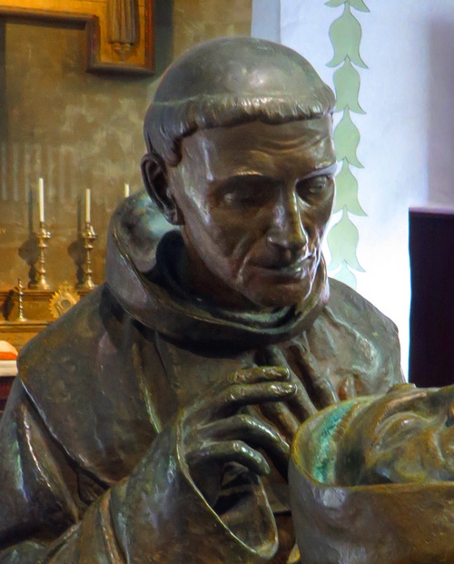
1924 statute of Father Crespi by artist Jo Mora.
No one knows what Fr. Crespi looked like because no one painted his portrait. The average Spanish colonial soldier was about 5’2” at the time. Priests might not have been much bigger. They had to have all been slim. By the time the expedition returned to San Diego, their diet had consisted of dead mules, although Crespi mentions in his diary that he found some plants he could eat. The image created of him at the Carmel Mission, where he is buried next to his friend Serra, is as good as any of the man that thought up Los Angeles.
A Spanish colonial pueblo was enormous. The pueblo proper of Los Angeles, founded by Governor Felipe de Neve where the 48 year old Franciscan priest born on the island of Majorca in Spain had recommended on ground moderately higher than the river at the base of today’s Elysian Park, consisted of twelve home sites, a central plaza, a granary, two administrative buildings and a guard house. The pueblo lands, however, were four leagues square. A league is equal to 4428.4 acres. Square that. A big red rock in front of the Scientology Media Productions at 4401 Sunset marks the northwest corner of the pueblo but no Spanish people lived that far away until Spanish governor Fages granted Vincente Feliz the Rancho Los Feliz in 1795.
Jodi and I sat at Nick’s counter and had breakfast. Hers had a slice of ham as big as a regular dinner plate.
Then we walked up along what was once Toma Road imagining the fields of wheat that grew in The Cornfield, wheat and lentils and garbanzos and corn, which once fed the pueblo, all irrigated by the zanja that drew water from the river. It looks post apocalyptic now, but then, so does everything else around there.
The day by then was hot. Jodi took photos of the fruit trees that someone planted in decorated garbage cans filled with dirt.

Photo by Jodi Siegner
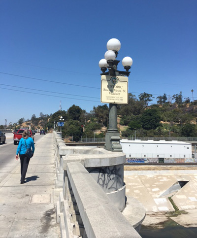
We sat for a time in the shade in Downey Park, where the first Europeans in California had camped, and then walked along the Broadway Bridge, at one time the fording place for priests coming from the mission to the pueblo for mass or last rites. She took a photo of the sign showing it was once the Buena Vista Bridge. Photo by Jodi Siegner
We went up on a grass verge on the west side of the river, and Jodi took a photo of the historic marker that is on the wrong side of the river, near the Portola trail, a trail Portola never used.
Then I saw the black shadow of a water wheel on the hot sidewalk. The water wheel carried water up from the zanja in 1860. If you look at the photo from the Los Angeles Public Library that accompanies this essay, you’ll see in the foreground the area that is now Broadway and below it the agricultural fields that were to become the train yard, which you can see (as train yard) in the noir film This Gun for Hire. If you look hard at the photo, you can see the Cornfield was then still farm land, and you can see Toma Road and on the other side of it trees reflected in water, which is where the river once was.
Nick’s was to be built 88 years later at about the clump of trees at the end of what you can see of Toma Road at the right hand side of the LAPL photograph. The tiny cluster of white adobes at the far distance – actually, about a mile from where the photographer stood – that is the city of Los Angeles.
Jodi took a photo of the Solano Canyon sign that cast the shadow of the water wheel on the hot concrete.

Photo by Jodi Siegner

Water wheel at entrance of what is now Solano Canyon, circa 1860. Courtesy of Los Angeles Public Library
We thought we should be able to get back to Nick’s through the Cornfield but you can’t. There are railroad tracks and three fence barriers with barbed wire on top.
Jodi said, “I’m not climbing over barbed wire,” almost as if it were an issue, as if I were going to urge her to climb over barbed wire or if I was going to or if I even briefly thought of climbing over three barbed wire fences or even one.
We race walked through Chinatown moving through strangers to get to College – a street that existed with that name when Alpine was still named Las Virgenes even though there is no college on College and possibly no virgins on Las Virgenes and we made it to Nick’s, jumped in and Jodi drove furiously to Union Station where she threatened some of the drivers with death for going so slowly.
I got out before the guards made it to Jodi’s car. I dragged my suitcase through the long hall to the Megabus and then rode on the top story of the bus around the back of Dog Town to the 5 seeing all the ugly everything and the dry hills.
See: Blake de Pastino, February 25, 2014, Western Digs: Dispatches from the Ancient American West, “History of Ancient Los Angeles Was Driven by Its Wetlands, 8,000 Year Survey Finds.” http://westerndigs.org/history-of-ancient-los-angeles-was-driven-by-its-wetlands-8000-year-survey-finds/.
Youtube of the iconography of Dogtown: https://www.youtube.com/watch?v=FKR2RO-Lt9c.
Comments
Leave a Reply
You must be logged in to post a comment.


