
Honey does Dogtown
NOTES FROM ABOVE GROUND
By Honey van Blossom
(Honey is a Belgian Marxist former strip-tease artiste)
Dogtown. Courtesy Los Angeles Public Library
The history of Dogtown is not a cooperative subject. Its past is scattered through libraries and archives and some of it may be in library basements. Internet and the linked-in library lending system allows some of these sometimes gleaming fragments to be excavated. Information gleaned from books that were based on unintentional misreadings of history and from librarians’incorrect dating and location of information challenge anyone’s attempt to sequence what happened in Dogtown.
Dogtown’s history tells us several stories.
One story is that — after the arrival of the Southern Pacific Railway to Los Angeles — rich farm land along a beautiful river was gradually turned into what today looks an industrial wasteland from a Philip K. Dick novel set on the banks of a ghost river crowded with weird non-native plants, plastic bags hooked on those plants thrown from cars, treated sewage, non-treated street waste, industrial effluent and graffiti.
One story is about the lives of people that lived near the industries in shacks, sheds, box cars, ramshackle old houses that had been fine places to live at one time, people exposed to tuberculosis, to plague, to every disease possible because of inadequate sanitation and pollution from the packing houses, the train yard, and industry.
The stories about the individual lives spent on the western bank of the river below the narrows are difficult to pull out of the early written history.
“Los Angeles” was four places until the Gold Rush brought in the Chinese people and the people from Mexico that returned from the mines. The four places almost make a rough circle or ovoid. These four places were the original settlement, which I call barrio 1, located on a ledge at the base of Elysian Park a little bit upriver from today’s Broadway Bridge; the second was barrio 2 or Dogtown; the third was the area that surrounded the Indian village of Yang-Na, and which is today Union Station and its tracks up to the church called La Placita; and the fourth was a few scattered houses on the elevation that became known as Sonoratown after 1850, today’s Chinatown.
No writers like William Saroyan from Fresno or John Steinbeck from Salinas have so far emerged from the classes at Ann Street School in Dogtown or from the apartments in the William Mead Homes, but we have photographs.
To somewhat understand the transitions that occurred in a little over 100 years, we should go back to the beginning of Dogtown, when the first Europeans arrived in inland Los Angeles.
An enduring myth is that no one knows where the pueblo of Los Angeles began. At one time, however, most people that thought about that question figured out that the first village (barrio 1) began a little below the toma or dam, and that the toma was a little below the confluence of the Arroyo Seco and the river. No one that knew the location, however, came out and said where it was — instead referring to the location cryptically.
Others, however, imagined the original settlement to have been somewhere in the south or somewhere in the area now occupied by Union Station or possibly up the hill in the Chinatown area going into the Temple Street area.[1] They referred to barrio 1 in Delphic tones, as if the location were a mysterious place lost in time.
Losing barrio 1 was fairly simple: it was tucked behind a slope of today’s Elysian Park. Southern Pacific Railway laid tracks through it. Also, the Native American people that had lived in a large and important trading village in the center of what would be barrio 3 had vanished, no one mentioned those people at all for a long time.
Memories of what the Indian road to that village had been like dimmed. The city evicted the Indians in 1836, which means that in 1886, when J. M. Guin started looking for barrio 1, there were elderly people that could have told him where the road had been. The road once started at the opening to barrio 1, continued through barrio 2, and ended up at the eastern edge of Yang-Na. That Indian road became known as Toma Road or Toma Street.
Once you know where barrio 1 was, figuring out the location of barrio 2 is easy.
- M. Guinn came close to describing barrio 2. “As the town grew, it straggled off from its nucleus – the old plaza in an irregular sort of way – without definite plot or plan….Fifty years after the founding of the Pueblo there was not a regular laid off street within its limits. Indeed there was but little necessity for streets. There were no wheeled vehcles, save a few old screaking carretas, used for hauling brea or asphaltum….”(Guinn, “The Plan of Old Los Angeles,” page 43). Screaking is a real word. The carretas hauled much more than brea. They also hauled people, food products, chairs, animal hides, tallow and porcelain dishes from China with blue pictures of temples. There was a carriage and blacksmith shop in 1857 at Commercial and Requena Streets and a stage coach from San Pedro before that. The streets were not much better in 1857.
A second myth is that barrio 1 was swept away in the flood of 1815 and that those people relocated to today’s downtown plaza. There is zero evidence any flood swept away barrio 1. Father Crespi had earlier warned the river flooded in his diary entry for the return trip of the Portola expedition in January 1770. Governor Neve sited barrio 1 above the river on a terrace at the base of one of today’s Elysian Park hills at a moderate elevation.
The 1815 flood may have led to Governor Sola’s decision three years after the flood to abandon the foundation for a church in barrio 2. The barrio 2 settlement probably centered in the low lying ground in Dogtown, although, if J. M. Guinn’s description was correct – sometimes he was correct – then those people that straggled off its “nucleus” remained, thinning out after the 1825 flood.
Flooding replenishes soil and nutrients to floodplains. For that that lived along the Nile River in ancient Egypt, the river’s flooding was called “the gift of the Nile.”
Neither the first nor the second barrio relocated. Settlement came to a halt in the first barrio because it had limited space, and population decreased in the second barrio after 1818, becoming denser in the third area, the area around the completed church building, adjacent to the village of Yang-Na. A few built houses in higher ground along the mesa below today’s Elysian Park in today’s Chinatown (barrio 4).
There were not that many people in Los Angeles, perhaps 83 houses total in 1823.[2] By the 1830s, about 800 people, possibly including Indians, lived in the new city.
Mark Wild, the author of Street Meeting: Multiethnic Neighborhoods in Early Twentieth-Century Los Angeles (University of California Press 2005) wrote: “The new arrivals (to Sonoratown) did little to change the area’s relentless poverty. In 1927 the normally more tolerant Louis Adamic dismissed North Main Street, its primary thoroughfare, as ‘a moron stream, muddy, filthy, unpleasant to the nose, .. an awful stew of human life.’” [3]
The main thoroughfare in Sonoratown was North Broadway; barrio 4 was not muddy, filthy, or unpleasant to the nose in 1927.

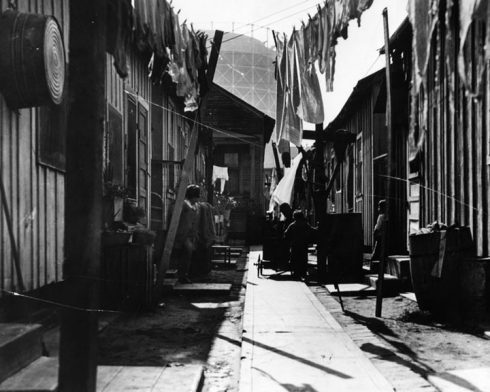
North Main Street at Elmyra Street in Dogtown, 1952. Courtesy of Los Angeles Public Library.
Sonoratown began to disappear as a Mexican community in the early 1900s. It had by then become a desirable area. By the turn of the 20th century, Los Angeles’s Little Italy had expanded from Olvera Street and North Main into present-day Chinatown.
North Main was the main thoroughfare through Dogtown.
Wild also wrote that at the turn of the twentieth century about 23,000 people living within the city limits were non-white or foreign-born whites. In 1930, that number was more than 360,000. Wild:
“Most likely, the first signs of these alternative migrations escaped the notice of the wealthier tourists and settlers who arrived in Los Angeles by train around the turn of the (twentieth) century. Their eyes may have passed over, for example, the cluster of shacks along the riverbed beneath what would become Lincoln Heights. Nicknamed ‘Dogtown’ byAngelenos, the settlement housed Mexicans and Italians who worked the railroads that connected Los Angeles to the rest of the world.” [4]

Naud Street in Dogtown, 1952.
Dogtown was named after an animal shelter. In 1885, a dog pound was located between the North Spring Street Bridge and Baker. In 1929, the city built a new dog pound on land between on Ann Street between Naud Street and Wyse Street, so probably at 214 West Ann Street, which today is a parking lot for the Chinese herb company. In 1988, the animal shelter in Lincoln Heights across the river was built.[5], are excused therefore for saying there was a cluster of shacks along the riverbed beneath what would become Lincoln Heights. Nicknamed ‘Dogtown’ by Angelenos, the settlement housed Mexicans who worked the railroads that connected Los Angeles to the rest of the world.” A cluster of shacks may also have been in Lincoln Heights, but Dogtown was on the other side of the river along North Main Street on the western side of the river.
The first person to describe in writing the area that would become Dogtown was Father Juan Crespi, a Franciscan padre that accompanied the first European land expedition in Alta California. Crespi wrote in his diary on August 3, 1769:
“At half-past six we left the camp and forded the Porciuncula River, which runs down from the valley, flowing through it from the mountains into the plain. After crossing the river, we entered a large vineyard of wild grapes and an infinity of rosebushes in full bloom. All the soil is black and loamy, and is capable of producing every kind of grain and fruit that may be planted. We went west, continually over good land well covered with grass. After traveling about half a league, we came to the village of this region, the people of which, on seeing us, came out into the road. As they drew near us they began to howl like wolves; they greeted us and wished to give us seeds, but as we had nothing at hand in which to carry them we did not accept them. Seeing this, they threw some handfuls of them on the ground and the rest in the air….”[6]
Herbert E. Bolton followed the route from the July 31, 1769 campsite – which was at a native village where the present San Gabriel Mission is located — to the river’s edge and determined the Portola camp site on August 2, 1769 was about where the Broadway Bridge crosses the river from the eastern bank of the river. That location is the site of the Downey Recreation Center.
John Walton Caughey was one of H. E. Bolton’s doctoral students. Professor Bolton had done the research for and written the 1927 book that contains descriptions of Portola’s 1769 expedition and 1770 return from what is today Antioch, California.
Caughey’s first book, California (1940) influenced generations of history students. His more than 25 published books included Los Angeles: Biography of a City (University of California Press 1977). With Norris Hundley — one of Caughey’s former students — Caughey wrote California: History of a Remarkable State (Prentice Hall 1982).
In California: History of a Remarkable State, at page 48, Professors Caughey and Hundley wrote about the founding of Los Angeles:
“The site for the pueblo had been foreordained by the discoverers in 1769 and by Neve in his reconnaissance in 1777. It was to be a short distance below where the river Nuestra Senora de la Reina de Los Angeles de Porciuncula emerged from the narrows between the Santa Monica and San Gabriel mountains. With the toma (dam site) and the course of the zanja in mind, a plaza would be located, with solares (building sites) around it, and suertes (planting lots) in an adjacent tract.”
The geographic definition of a river’s “narrows” is the narrowest part of the river. Neve did not write about it in his instructions or in his letter to Bucareli. Caughey and Hunley bunched their sources together at the end of the book. The only obvious source was H. H. Bolton’s book about Friar Crespi.
There is no archeological evidence of the Spanish Colonial habitation in Dogtown, and there is no archeological evidence that proves that the original settlement was a little above today’s Broadway Bridge – the bridge marks the place Portola crossed the river following an Indian road that led from the site of today’s San Gabriel Mission to the former Native American village of Yang-Na. The present plaza church was built on a portion of the pueblo’s trashpit.[7] The trashpit held whatever archeological artifacts that remained from the earlier time (before 1818), not counting the pieces of the zanja concrete and brick conduit, constructed in 1875, unearthed in New Chinatown. If there is any other physical evidence, it is under something: a beauty supply warehouse, a road, an electricity transmission depot, the concrete channeled river.
What we have to tell us about the history of Dogtown that began about 1790 are roads, the municipal archives showing the eviction of Yang-Na in 1836, a sketch for the E.O.C. Ord survey and following surveys, the location of the toma that has been known since it was first built, Father Crespi’s diary entry, Neve’s 1781 instructions for the establishment of pueblos, the Laws of the Indies, and photographs.
No road, other than what looks like a narrow footpath by 1875, existed where marker 157 stands until 1909, although there was a horse car line that went a portion of what is now North Broadway before 1888.[8] There was also a path from the Cavalry Cemetery by 1875. Downey Avenue was on the west side of the river. The route is now called North Broadway on both sides of the river.
Herbert Eugene Bolton remarked on the location of the August 2, 1769 campsite in Fray Juan Crespi, Missionary Explorer on the Pacific Coast 1769-1774, (University of California Press 1927). From Father Crespi’s description of what he saw from the campsite, it was where the Downey Recreation Center is today. The tiny village Felipe de Neve sited, following Crespi’s recommendation, is across the river from the August 2, 1769 campsite. It was where today’s Metro Gold Line storage yard stands to today.
The 1790 census of Los Angeles lists the names, casta categories, and occupations of the people that lived in the entire pueblo, although the census does not describe anything about the Indian population.[9] William Mason lists 31 families living in Los Angeles in 1790. The total number of people in Los Angeles (not counting Indians) were over 100. Their ethnicities were Spanish, mestizo, coyote,[10] mulato, and Indian from Mexico. The husbands’ occupations were mostly as farmworkers. There were also muleteers, cowboys (vaqueros), a weaver, and a tailor.
In 1810, a census counted 365 people in El Pueblo de Los Angeles.
The original settlement on the western bank of the river by 1786, contained 43 people on 13 homesites. The propios, lands held in common by the settlers, were developed after 1790 as farm land. This area — the common lands –was a little above barrio 1, shown as “tierra para las propios” in Jose Arguello’s 1786 map of the pueblo. From a map sometime after 1790, these became agricultural plots. The area that was once the propios is under today’s concrete channel. The suertes were in the large area that is now partly occupied by the Los Angeles state historic park. These lands extended as far as Toma Road, roughly North Main when it goes through Dogtown.
In a footnote,[11] Bancroft copied a list of all the pobladores, ninety-one of them, down to February 1816. Fourteen had received lands “in the pueblo,” which had passed into the hands of their children or later settlers. Six still cultivated the suertes given to them. Fourteen had received no lands but had cultivated the (probably) propios developed as farm land probably an area inundanted by river sand whenever there was a flood. Ten citizens had no lands but cultivated a garden. Five lived or worked with relatives.
There was no room in the original settlement for 315 people, and the agricultural land (Today’s Los Angeles State Historic Park plus the area in today’s Dogtown to today’s North Main.) Some families likely moved to an adjacent neighborhood — agregado[12] — and the only adjacent area where people could build houses was along the Indian road to Yang-Na, Toma Road; that is, Dogtown.
Soldiers from the Santa Barbara and the San Diego Presidios retired in Los Angeles, among them invalids. In a few instances, the government sent women to the pueblo from Mexico, wives of settlers. Twenty orphan children arrived to be adopted by settlers before 1806.[13] One of the little girls, placed with the Carrillo family, said that the government distributed the children “como perritos.”
The friars at the mission complained that it was not possible for the two ministers to care for the pueblo and for the distant ranchos.[14] By 1811, the pueblo had outgrown its first chapel, and the residents petitioned for a new church. Father Gil came out from the mission to lay the cornerstone in 1814.[15]
A part of Toma Street was called once called Calle Principal. Calle Principal began at the eastern edge of barrio 2.
The church known as “La Placita” did not face the plaza in 1822. There was, however, a small plaza behind the area occupied by today’s church, which, after the ayuntamiento evicted the Indians in 1836, was called “la placita.” The larger area in front of the church occupied until 1836 by Indians – “the plaza” in various configurations shrinking eventually to its present size – and “the plaza’s” surrounding structures became the third barrio of Los Angeles.
The first survey of the city — the first surveyor of individual plots was Abel Sterns, who taught himself surveying from a book his brother sent him from Massachusetts – was E.O.C. Ord/William Rich Hutton’s La Plan de la Ciudad de Los Angeles, completed in August 1849. This survey, Hutton’s paintings (or drawings), and the Charles Koeppel lithograph show that “the plaza” up to 1853 was an area much larger than today’s, irregular in shape. It was not until about 1860 that “the plaza” had shrunk to a smaller rectangle. Sometime in the 1870s, “the plaza” became a circle. The circle downtown is what we know today as “the plaza.”
In 1988, Bernice Kimball compiled 540 pages of indexes showing how streets developed.[16] The entry for North Main’s creation includes San Fernando Street (which no longer exists), but I came across a survey that shows that part of what is today North Main was once called Chaves Street.[17]
In 1847, William Rich wrote his uncle that he and E.O.C. Ord walked 1.25 miles from the front of the church (“La Placita,” Our Lady Queen of Angels Church) to the last house on the principal road. The street called Calle Principal connected to what had previously been called Toma Road. He might have taken another route to the south, but there was no house to the south until he might have come to the Dominguez Rancho, and neither Ord nor Hutton considered the ranchos part of the city of Los Angeles. Hutton may have seen one of the structures remaining from the original settlement. Neve, after all, sited the first barrio on a moderate elevation, even though it was right next to the river. Its structures could have survived the 1815, the 1825, and the 1862 floods.
At the time of the drawing of La Plan de la Ciudad de Los Angeles, either Ord or Hutton sketched a survey, an incomplete survey with few details, not apparent in the copies of the original survey we have.[18] As may be seen from the Ord or Hutton sketch and from the survey six years later of the Wilhardt tract with property lines straightened, the “tracts” of Dogtown were still large areas with a few structures set in agricultural land at the end of the 1840s.
By 1849, all that seems to have remained from the agregado seems to have been the few structures that Ord/Hutton indicated in the sketch of “the large parcels to the east of Main Street,”[19] scattered through the tracts near the river, including a large structure that had been the old Peralta adobe – large in comparison to some of the single room adobes. The Avila Adobe (1818) by today’s plaza is probably about the size of the (first?) Peralta homestead. The Avila Adobe was probably one of the first structures built in the third barrio.
The native people of Yang-Na were an important work force. They had helped the first settlers voluntarily in 1781. The Indians worked in the fields and received one-third of the crop. The Indians built the adobe houses. The vecinos[20] and the Indians would have traveled frequently on Toma Road. Moreover, the way to the San Fernando Mission and from the mission to Ventura — initially would have been on El Camino Viejo. The road to the harbor in San Pedro also started at Yang-Na.
The road to the San Gabriel Mission – the most important road in the earliest days of the pueblo – started at the fording place (marked El Camino Real on the 1786 map) and then went along the river a bit and then descended along what would be called Toma Road. To celebrate mass, the priest traveled from the mission, crossed the river at today’s Broadway Bridge location, and traveled on Toma Road. There was no church in barrio 1; mass was held either in the guardhouse or in one of the two administrative buildings.
The vecinos petitioned for a new church in 1811. In 1814, Governor Sola authorized the people to errect a new church. He asked them to give 500 pesos worth of their animals to pay for the building.[21] Father Gil came out from the mission to lay the cornerstone for the church in 1814.
The likely site of the foundation for the 1814 church was at a short distance from the original settlement, in the agregado as it was then (changed somewhat by the 1815 and 1825 floods) at the edge of what would be called the Wilhardt tract near the river, and along Toma Road or a short distance behind Toma Road.
The flood of 1825 resulted in further changes in the river’s contour. The first church’s foundation and the adobes near it could well have been inundated, as could have a second plaza in the agregado, if there was one. No one made a map of this community. There is no map of the river as it was in 1824 or 1825 — no map at all until the Ord survey after the sketch identified as “Coronel” in subsequent litigation over the size of Los Angeles. It is unlikely that Lincoln Heights, on the eastern bank of the river today, was the site of this community (barrio 2) because there were high bluffs on that side of the river. The Lincoln Heights bluffs and the Boyle Heights bluffs on the eastern side of the river and the hills of today’s Elysian Park and its terraces constrained the river’s flow. That narrow area of river flow was likely at one time “the Narrows.”
The remains of the second barrio, the agregado, were either buried under the river’s concrete channel or interred beneath North Main just before it crosses the river or under today’s buildings near or on North Main at the top of what had been the Wilhardt tract.
The 1900 L.C. Fletcher topographic map in the Los Angeles Public Library digital library (Map-00043) shows that there was lower area was next to the river, a depressed area along the western bank. The top of what is today North Main Street — once more or less Toma Road — is in that depressed land area. Back in time to 1818, when Governor Sola dictated that the foundation of the first church should be abandoned because the river’s change in course after the 1815 flood purportedly endangered that foundation and should be built instead at the location of today’s La Placita, that foundation was likely at the top of Toma Road, or the edge of today’s North Main just before the bridge to the east side.
If the agregado was inundated in 1825, some of those people living in it would have moved to the area near the church completed in 1822, La Placita, which faced Yang-Na. The ad hoc migration of some of the vecinos that had begun in about 1818 would have been completed in 1825, and the third barrio then surrounded Yang-Na.
In 1836, Abel Stearns became sindico or fiscal agent of the town.[22] A sindico was more than fiscal agent. Translators interpreted the word to mean “city attorney,” but he was not an attorney-at-law. He was something like an attorney-in-fact, a representative. The sindico was a man “of recognized ability, social category, and political influence.[23] Stearns’ biographer Doris Marion Wright did not mention the city’s decision to evict the native people from Yang-Na. The index to her book does not list the word “Indian” nor does it list “Yang-Na.”
I have not discovered where it is that historians thought the original Yang-Na was although I have come across references to Commercial Street, the location where the city moved the native people to in 1836. Google maps shows Yang-Na at that location.
Although Stearns has frequently been referred to as Jewish, there is no evidence that he was. Recently, in an article about Eric Garcetti, Stearns was mentioned as the first Jewish mayor. There is no record indicating Stearns had been a mayor of Los Angeles.
No one knows much about Stearns before he came to Los Angeles in 1828, when he was thirty, He had been orphaned when he was twelve. He worked on a ship.[24] He had first married when he was eighteen or nineteen in Boston. He and his first wife had a child that died when he was twenty. He had a second child but Stearns’ biographer found no record of what happened to his first wife and his son.[25] He moved to Mexico, where he – like Hugo Reid – worked as a trader, buying and selling merchandise before moving to California.
He was the one that brought the first stage coach to Los Angeles after building a warehouse at San Pedro. The Mexican government charged him with smuggling, but that was not proven. Smuggling was a common practice both in the Spanish era and the Mexican era because of severe regulation in the first era and heavy taxation in the second era.
The Capitol Milling facility is almost two hundred years old, and its construction marked the beginning of the cornfield area as one that would become increasingly industrial over half a century before Southern Pacific Railway built the rail yard. An 1856 George Hansen survey of the previous incarnation of Capitol Milling – Eagle Mills/Stearns Mill — reveals the location of the toma at the base of an Elysian Park hill, the then-path or road fording the river, the zanja leading past barrio 4 (today’s Chinatown, once Sonoratown – College Street still exists, Virgin Street has become Alpine Street — towards barrio 3 (today’s plaza area). In this survey, Toma Street goes past Luis Wilhardt’s parcel, which is an irregular shape somewhat octogonal. The river goes near Wilhardt’s tract. Main Street just stops at the edge of privately possessed, if not actually owned, parcels, but the red line from Main Street joins or is Toma Street.[26]
This 1856 survey is on the Huntington digital library site, which means you can navigate through the landscape, expanding and contracting the image. The toma, very near to the original settlement (barrio 1) was not that far from the Wildhardt tract, which was likely the site of the agregado.
The Stearns lived in what became the site of L.A.’s “Baker Block,” then called “El Palacio.” It was a large one-story adobe house formed in an ell, with a large room for dancing and music.
The city government sold and gave away its municipal legacy as fast as it could in the 1850s. It had no way yet to raise money other than selling off the land that had become marketable after the transition to the American government and after the Ord survey. Land was emphatically commodified after the American era began .[27] Wright pointed out that, before the American era, no one had title to any land, going back through the records of Los Angeles in 1781. Possession was not 90 percent of the law. It was 100 percent. Stearns bought the land for El Palacio, paying for it in hides and tallow — the common practice in the barter economy — but he had no title to it anymore than anyone else had title to real estate. He was the first to urge surveys, and because there was no surveyor, he taught himself.
Arcadia signed her marriage contract with a mark. She could not write her name. During the Spanish and Mexican eras, Wright wrote, literacy was considered wasted on women. Arcadia never learned to speak English well. Governor Sola had established a school for boys in Los Angeles in 1817, and a school for girls opened near the plaza in 1827, so Stearns’ biographer is not completely accurate. Arcadia was born in 1825. She could have gone to school but her family had not thought it worthwhile for her to do so. Perhaps the photograph taken of her when she was about thirty did not do Arcadia justice. She was considered to be the most beautiful woman in Los Angeles but the photograph shows her to be a fat lady with a pleasant Italian face and thick dark hair dressed in expensive clothing. Her expression is complacent, passive.
Arcadia’s younger sister acted as the Stearns’ housekeeper, and the servants (Indians) did the work, according to Wright. When asked to sing, she responded that she did not sing. She enchanted, she said. Arcadia did enchant although it is difficult from today’s perspective to see why she did.
On the site of Abel’s El Palacio, the Bakers built the Baker Block, an imposing Victorian structure next to the Bella Union Hotel – the Bella Union started life in the late 1820s as a one-story adobe, the structure became the center both for local government and also where L.A.’s newspaper the Star/Estrella was located. Arcadia Street, at the other end of the Baker Block, runs along the 101. From a 1940 photograph, the Baker Block by then provided cheap rooms. A sign in front of a sagging awning for a market and liquor store read, “Nos Cambianos 8 Puertas a norte.” The Bella Union’s marquee in 1940 read “MONEY TO LOAN.” Next to the Bella Union was the Azteca Café. That area is part of the Fletcher Bowen mall and Triforium today.
After Abel’s death, Arcadia married Col. Baker, a real estate developer. She owned a portion of the agricultural field until the 1880s, when she sold it.
The story of Abel Stearns is the background for why there is a Baker Street at the edge of Dogtown. It was named after the area’s previous owner: Arcadia Bandini Stearns de Baker.
One of the older agregado stories is about a young man from Bavaria that came to Los Angeles and married into the Peralta family, thereby acquiring a vineyard in the agregado. A street in Dogtown is named after him.
Juan Jose Peralta appears as a resident in the 1790 census. Juan Jose Peralta was of Spanish origin, suggesting he was “white,” married to Isabella Berreyesa, listed as a “coyota,” or Hispanicized Indian, from Sonora, Mexico. They had no children. Another Peralta family – the husband Nicolas Berreyesa, Mestizo, the wife Maria Gertrudis Peralta, Spanish (from Sonora, so probably a sister or cousin of Juan Jose and Nicolas Berreyesa was probably a close relative of Isabella Berreyesa.) Gabriel Peralta was 55 at the time of the 1790 census, a retired corporal, Spanish, from Sonora, living in the agregado. Gabriel Peralta had been a soldier with the Juan Bautista de Anza 1776 expedition. He was to die in San Jose aged 93.
Luis Maria and Pedro Peralta were Spaniards from Sonora. The Luis Maria Peralta Adobe (1804) still stands in San Jose, near the Santa Clara Superior Court. Corporal Gabriel Peralta is listed as one of the first settlers of San Jose in 1778.
If the various people with the last name Peralta of San Jose and of Los Angeles were members of the same family, members of the agregado Peralta family were very familiar with the idea of a plaza surrounded by house sites. Both the original 1778 San Jose settlement and the rebuilt pueblo proper (after a flood of the Guadalupe River) were laid out according to the Laws of the Indies.
Luis Wilhardt arrived in Los Angeles from Bavaria in the1800s and married into the Peralta family. He was born in 1821 and christened as a Catholic in La Placita in 1849 and married Maria Candelaria Peralta a month later, also in La Placita. [28] A website devoted to the winery he established states he purchased the property in 1830,[29] which is impossible, because that would have meant he started the winery when he was nine years old. He probably acquired the land as other early immigrants did – through marriage.
The Wilhard(sic) tract map shows the land was below Toma Road and adjacent to a zanja on one side and the land of Jose Maria Ibarra on the other.[30] Juan Antonio Francisco was a soldier escort for the Los Angeles Pobladores in 1781, and he had been accompanied by his wife and first child. Francisco Ybarra, “color quebrado,” (“person of mixed blood”) and his wife Maria de Los Angeles Velasquez, were not listed in the 1790 cenus. In 1790, they resided at the San Diego Presidio. In 1812, the family arrived in Los Angeles. They had five children, none of them named Jose. Jose Maria Ibarra may have been a grandchild of Maria and Francisco.
A photograph in the Los Angeles Public Library photographic archives of the Los Angeles Infirmary established by The Daughters of Charity of St. Vincent de Paul in 1856 in Sonoratown and then moved to Dogtown in 1860 at what would be after the 1880s either 1414 Naud Street or 1416 Naud Street shows a little of the subsequent development of Dogtown.[31]

Sister’s Hospital, 1416 Naud Street, ca 1889. Digitally reproduced by the USC Digital Library. From the California Historical Society Collection at the University of Southern California.
An 1862 photograph of Judge William Dryden’s water wheel[32] (built between 1858 and 1860) at the entrance to Solano Canyon – thirteen years before Southern Pacific Railway built the rail yard that covered a portion of the pueblo’s 1786 agricultural fields – shows that the area now occupied by North Broadway was then, as now, on considerably higher ground than the fields below and shows the principal road as a white line headed towards the tiny white structures in the distance apparently – but not actually – at the base of mountains, the third development in Los Angeles. The area that will be Dogtown is on the other side of the white road that can be seen in the photo’s middle ground.

1862 photograph of Judge William Dryden’s water wheel, above the Los Angeles State Historic Park at the entrance to
Solano Canyon.
If agriculture (or parks, as suggested in the 1930 Olmsted-Bartholomew Plan[33]) had continued (or had been created) along the river’s edges, the river’s occasional flooding would have been absorbed by the riverine land and plants.[34]
The undated George Hansen survey of San Fernando Street (once Upper Main Street, before that Toma Road – sometimes Tomas Street — now North Main) shows a few structures.[35] The 1875 “Map showing the location of the old Zanja Madre, ditches, vineyards and Old Town, etc.” [36] shows one structure at the end of a road and numerous irrigation ditches – all the ditches coming from the toma that was around the bend in the river at the base of Elysian Park.
A survey showing the Southern Pacific Right of way — colored red –indicates a new road was then carved through the agricultural fields, called “New Road to Arroyo Seco.” The right of way was donated, but the map does not show who donated it. The top of Toma Road or Street was lopped off by the railway.[37]

Naud Street, 1952.
The 1885 subdivision map locates Naud Street, Wilhardt Street, Downey Avenue and Chaves Street. There were several structures in the subdivision, including a Blacksmith’s shop and the Old Dwelling of the Wilhardt family. The Old Dwelling was built at an angle between Naud and the Ybarra Vineyard. Wilhardt Street is to the east of the Old Dwelling. A (newer) frame house belonging to the Wilhardt family was built closer to Wilhardt Street.[38]
Naud Street and Naud Junction are named after Eduoard Naud, a French pastry baker who owned land in the second barrio, the agregado, today’s Dogtown. In 1850, Naud opened a pastry shop on – according to Big Orange Landmarks: No. 211 – on Commercial Street. Glen Creason writes that Naud became famous for his ladyfingers. Naud built a wool market at the junction of Alameda and Main. Creason wrote that the warehouse was also packed with pianos, furniture, farm equipment, printing presses, organs, baby carriages and steamer trunks. Eduoard Naud died in 1881. In 1905, a boxing pavilion was built at the Naud.[39]
In 1910, before the introduction of Aqueduct waters, Los Angeles led all the counties of the United States in value of crops.[40] Los Angeles’ importance as an agricultural producer began to change in 1875, when the trainyard was constructed.
The location of the rail yard provided neighboring industries with cheap transportation. The railway changed Dogtown from agricultural to industrial/residential.
Madeleine T. Bray and Monica Strauss, “Domestic Life in Turn-of-The-Century Los Angeles: Contextualizing A Historic-Period Archaeological Site.” SCA Proceedings, Volume 29 (2015), page 152. https://scahome.org/wp-content/uploads/2015/11/Proceedings.29Bray.pdf. (Retrieved 1/13/2018)(Herein referred to as “Bray and Strauss.”):
“Founded in 1781, Los Angeles remained a relatively small and unimportant town through the1870s, when its population numbered about 5,000. However, a significant period of growth began after the city was connected to the transcontinental railroad: first the Southern Pacific Railroad in 1876, and then the Santa Fe Railroad in 1885 (Citing Larry Mullaly and Bruce Petty, The Southern Pacific in Los Angeles, 1873-1996 (Golden West Books, San Marino, California 2002) and Richard Orsi, Sunset Limited: The Southern Pacific Railroad and the Development of the American West, 1950-1930 (University of California Press, Berkeley 2005).) The resulting rail fare wars led to an unprecedented real estate boom, as well as affordable cross-country fares. Low rail fares and the promise of a better life enticed immigrants from other parts of the United States and the world to Los Angeles. Settlers flooded into the region, and the demand for real estate skyrocketed. As real estate prices soared, land that had been farmed for decades outlived its agricultural value and was sold to become residential communities.” (Citing Cary McWilliams Southern California: an Island on the Land, Gibbs Smith, Layton, Utah 1946).
The 1870 census showed that the leading industry was the making of flour and meal. Wine making came second in product value. Fifty people mined gold. Wool-related industries powered by water wheels on the zanja (There were nine.) contributed to the local economy.[41]
Bray and Strauss, page 153:
“The balance of residential and industrial uses in the area tipped in favor of industry beginning in the 1910s, when the City Council established an industrial district between Main Street and the river (citing Mark Wild, Street Meeting: Multiethnic Neighborhoods in Early Twenty Century Los Angeles, University of California Press, Berkeley 2005).[42] Throughout the next few decades, zoning changes encouraged industrial development while at the same time discouraging residential development and upkeep…”
Mike Davis, in “Sunshine and The Open Shop,”[43] wrote:
“In a 1906 survey of Los Angeles’ ‘proletarian wards,’ W. A. Corey, a local Socialist leader, estimated that the sixth, seventh and eighth wards—bounded by the Fremont gates of Elysian Park (north), Main Street (west), the Los Angeles River (east) and Vernon Avenue (south) contained 80,000 people. (Citation) Although the comprehensive subdivision of south-central and east Los Angeles after 1920 siphoned off the majority of this population, a WPA survey found 916 households persisting in the area between Alameda and the river as late as 1940… . In short, it took landowners and the railroads, supported by city planners and housing reformers, nearly forty years to establish uniformity of industrial land use.”
Manufacturing plants first sprang up along the river where railroad facilities were convenient.[44] Inasmuch as the early mills used waterpower – back as early as the Abel Stearns mill built possibly in 1822 now the Capitol Milling building – location near the river was critical.
After 1900, the greatest value of products came from the slaughterhouses and meatpacking.[45] In 1909, the leading industry was foundry and machine shop products. Publishing joined meatpacking, lumber, gristmill, petroleum-related manufacturing businesses. At right about that time, the movie industry became established in the Edendale district, moving on later to Hollywood and Studio City.

Library of Congress 1909 Birdseye Publishing Company map detail showing the area from the SP Railway Yard south to North Main Street and Dogtown.
The 1909 Birdseye map[46], when you focus on the detail, reveals that just after Los Angeles passed its first zoning regulations, Barrio 2 was what would be called today Mixed Use.
Photos from the 1930s and later show an increasingly decaying neighborhood after the City zoned the area industrial, mediated a little by the images of The William Mead public housing (1942)[47] and of the former The Woman’s Building, founded during the feminist art movement in 1973, but within a 1914 Beaux Arts commercial building at 1727 North Spring Street, which had been a warehouse since the 1940s.
Wild, cited earlier, describes the “central city” – an area that included Dogtown – as follows:
“Central neighborhoods, riddled with poorly designed lodging houses, crude shacks, dilapidated house courts, and rickety single dwellings, did suffer from lower health and safety standards compared to Anglo areas…. Often several families had to congregate in a single dwelling to afford the rent. The drive to maximize rents through concentrated development led to poor sanitation and ventilation in central city dwellings and little open space for social gatherings and children’s activities. Racial covenants and exclusionary practices in other parts of the city inflated central city rents, and Angelenos priced out of the market sometimes slept in coal yards or cow stables.”[48]
Racially restrictive covenants – promises not to sell or rent to African-Americans, Mexicans, Greeks, Asians, Jewish people or Italians that “ran with the land” because they were promised in property deeds – meant that the newer areas were white Protestant. The United States Supreme Court did not rule that court enforcement of racially restrictive covenants was Constitutionally prohibited until 1948.[49] Those areas that did not have racially restrictive covenants confined immigrants and other working people in specific areas, which meant for high rents and crowding in those areas.[50]
Photographs from the Los Angeles Public Library — taken to show that there were slums in Los Angeles in spite of the City Council’s denial that they existed in order to obtain funding from the federal government for public housing pursuant to the Wagner-Steagall Act of 1938[51] — show that by the 1940s, the small nineteenth century houses had become dilapidated and the neighborhood had become an urban slum.
In the case of Dogtown, zoning as implemented from 1908 to the present, froze industry as the appropriate use of land. A land use map used in a planning essay produced by the city’s planning department shows, first, a concentration of industries along the river, including on or near the site of the Crystal Springs headworks. The Dogtown area is designated MR3. M3 is the heaviest industrial use.[52]

Map of Honey and Ronald van Ammers December 31, 2017, walk through Dogtown.
Ronald van Ammers and I took uber to the Downey Recreation Center, walked up to the Broadway Bridge and looked below the bridge to the place where Father Juan Crespi recommended a site for a mission or large settlement in 1769 and where the first governor of California sited it, saw ahead of us the dusky burnt orange MTA high rise office building behind Union Station, went back down to North Spring, took a jog through crappy streets to North Main (which has an odd connector road) – briefly entering the dead end Baker Street — passed an electric transmission plant behind a wall and then went down North Main to Olvera Street, which is in the front area of Union Station.
The MTA building may be near the back of what was the Native American village of Yang-Na. That is the approximate location of El Aliso, the giant sycamore that sprang from the ground in the fifteenth century.[53] El Aliso could be seen for miles and became the gathering place for the indigenous people. The tree can be seen looming in the background of the first photograph of Los Angeles, taken sometime after 1860 when “the plaza” downtown had shrunk to a rectangle.
Tongva villages included not only the central settlement, but also gathering fields, hunting territories, playing fields and menstruation huts. Yang-Na probably went as close to the river as El Aliso, the giant tree that loomed in the background of the first photograph of the plaza (sometime after 1860, after the Americans shrunk the area a lot and turned into a rectangle), and which was in the courtyard of the Vignes winery after 1833.

Gold Line storage yard, seen from the Broadway bridge. Photo by Ronald van Ammers.
Ronald and I went back to the Downey Recreation Center and crossed a narrow rather alarming road, passed by bicyclists that probably had no idea that the history of Los Angeles was forever masked after the Southern Pacific Railway bought the cornfields in 1875. We saw Los Angeles State Historic Park, which had been the rail yard and gas tanks that Alan Ladd fled across in the noir film This Gun for Hire (1942). The film is available on YouTube.
That inscrutable cityscape of the railyard with the big oil tanks behind it was what Ronald and I had seen when we were children. It was what J. M. Guinn saw in 1886 when he first arrived in Los Angeles. That area became the Los Angeles State Historic Park after litigation brought by activists.[54] Only after the area was cleared could the actual early history of Los Angeles be comprehended.
We emerged at Baker Street. A few men with cameras stood there.
We walked further and came across a man with a big wrench opening a fire hydrant. He opened the hydrant and washed a big black tarp with the water. We were at the edge of Dogtown, entering dystopia.
The presence of old cars parked in the middle of Baker Street and along the curbs near it suggested something was going on in the buildings.

Statue of naked lady on top of The Woman’s Building, 1978. Courtesy of Los Angeles Public Library.
We came to The Woman’s Building and saw a young white woman with a camera. She put it down when she saw us but her camera had been aimed at a beautiful African-American woman dressed in a white hijab standing in the doorway. That woman in the doorway smiled shyly at us. In 1973, three women – artist Judy Chicago, art historian Arlene Raven, and graphic designer Sheila Levrant de Bretteville – created the first independent art school for women in that building called the Feminist Workshop.[55]
There is a secret life growing in Dogtown like the weeds that break through concrete to flower in the streets of Los Angeles but I don’t yet know what the secret is: a Jane Jacobs-inspired or political anarchy movement, or an art that grows naturally in degraded neighborhoods, something that should be left alone by the planning department, because planners seek order whereas entropy distributes mystery.
We passed a Chinese import building with stylized lions in the courtyard, a wall with graffiti, elderly Chinese women waiting for a bus, women probably our age – there is a bus? An electricity plant, cyclone fences, parking lots – for whose cars? – a tiny mall with a coffee house and a lawyer’s office. Maybe the lawyer has many employees because no one else appears to live or work close to that little mall.
We passed the William Mead housing project, a product of a law concept passed by Congress during the Great Depression later destroyed by real estate interest lobbies in the 1950s and decried as socialistic but this project, and a few others, built before the 1950s in Los Angeles endured.
The map Ronald’s phone created of our journey revealed what I had not previously seen, that the road we took to and through Dogtown led us south, and that we passed near to the Men’s Central Jail and the Twin Towers correctional facility, buildings expressive of institutional effort to change the behavior of impoverished and/or mentally ill people.
Crespi’s half league from the crossing place of August 3, 1769 to today’s plaza is not that much of a distance to walk. It took us, however, through
We entered the Olvera Street market place. Members of a mariachi band son music walked by: three guitarists and a violinist, no trumpet.
[1] See, J. M. Guinn, “The Plan of Old Los Angeles And The Story of Its Highways and Byways,” Read December 2, 1895, Annual Publication of the Historical Society of Southern California, Los Angeles, Vol 33.3, No. 3 (1895), pp.. 40-50. https://www.jstor.org/stable/pdf/41167619.pdf?refreqid=excelsior%3A82847d4ec265f848c373aff00e362167. Guinn stated, “The boundaries of the Plaza viejo or old plaza as nearly as possible to locate them now, are as follows: The southeast corner of the plaza would coincide with what is now the northeast corner of Marchessault and Upper Main Street. From the said northeast corner of these streets draw a line northwest one hundred varas (278 feet) – this line would constitute the easterly line of the old plaza. On this line construct a parallelogram with its opposite or westerly side on hundred varas in length, and its northerly and southerly sides seventy-five feet each.” Upper Main was consolidated into North Main. Marchessault was behind the Chinese Theater. It was demolished for Union Station and Marchessault was erased. That area was probably one side of Yang-Na, so it may well have been after 1836 “the plaza viejo.” Or one of the plaas.
[2] August Duhaut-Cilly, A Voyage to California, The Sandwich Islands, and Around the World, translated and edited by August Fruge and Neal Harlow (University of California Press, 1997), beginning on page 142.
[3] Page 10. Professor Wild here cites Louis Adamic, The Truth about Los Angeles (Emanuel Halderman 1927, page 10) William David Estrada, in The Plaza:Sacred and Contested Space (University of Texas Press 2008), also cites Adamic’s description, in this case as a description for the area around the present plaza.
[4] Gilbert G. Gonzalez, “Factors Relating to Property Ownership of Mexican Americans and Italian Americans in Lincoln Hights, Los Angeles” in Struggles and Successes: An Anthology of the Italian Experience in California, ed. Paola A. Sensei-Isolani and Phylis Cancilla Martinelli (New York: Center for Migration Studies, 1993), 219-30. Cited by Wild, p. 19.
[5] City of Los Angeles Department of Animal Services, “Department of Animal Services: 153 Years of Animal Care.” https://www.lacity.org/department-animal-services-153-years-animal-care. (Retrieved 1/23/2018)
[6] James Miller Guinn, A History of California and an Extended History of Los Angeles and Its Environs, Volume 1, (Historic Record Company, Los Angeles, 1915). page 77.
[7] See, Lisa Kealhofer, Ph.D. Dissertation, Cultural Iinteraction during the Spanish Colonial Period: The Plaza Church site, Los Angeles Kealhofer, University of Pennsylvania, 1991.
[8] See, The Street Railway History of Los Angeles, The Electric Railway Historical Association of Southern California. http://www.erha.org/index.html. (Retrieved 1/17/2018).
[9] William Marvin Mason, The Census of 1790, A Demographic History of Colonial California (Ballena Press Publication 1998). The cover photo on the paperback edition shows Pio Pico and his wife. Pico’s wife was Antonia Ignacia Alvarado. Pio Pico was born in the San Gabriel Mission in 1801, so he could not have been one of those counted in the 1790 census. Antonia was born in 1808. Her father Francisco Javier Alvarado served as a soldier and official at San Diego and then at Santa Barara from 1780 until his death in 1818. See, Thomas Savage’s interviews, edited and translated by Rose Marie Beebe and Robert M. Senkewicz, Testimonios, Early California through The Eyes of Women, 1815-1848. (University of Oklahoma Press 2006). Another source lists several other names, origins, ethnicities and occupations. San Francisco Genealogy, “1790 census.” https://www.sfgenealogy.com/sf/ca1790.htm. (Retrieved 1/20/2018)
[10] “Coyote” was a Spanish Colonial term for blood mixture: Mulatto and Indian; mestizo and Indian.
[11] Bancroft, page 349, footnote 25. Guillermo Cota, who compiled the list, only counted the grown men. Women and children are not on this list.
[12] An agregado was a district (partido) attached to another for administrative convenience. Ophelia Marquez and Lillian Ramos Navarro Wold, “Compilation of Colonial Spanish Terms and Document Related Phrases,” (Second edition, 1998). http://www.somosprimos.com/spanishterms/spanishterms.htm.
[13] Id. Page 169.
[14] Bancroft, Id, page 113
[15] Bancroft, op cit., page 351.
[16] Bernice Kimball, Street Names of Los Angeles (Bureau of Engineering, 1988)
[17] Julian Chaves may not have been one of the owners of the large agricultural areas possessed, if not owned in modern American terms, in what would be Dogtown. He developed what became Chavez Ravine in 1860 and at one point owned a vineyard in the area that became Frogtown.
[18] “Plan de La Ciudad de Los Angeles: tracing of the large parcels to the east of Main Street.” http://hdl.huntington.org/cdm/singleitem/collection/p15150coll4/id/12828/rec/2, (Retrieved 1/24/2018) The Huntington librarians designated this an 1856 Ord map, but by 1856 Ord was as a captain serving in the Pacific Northwest. The “Wilhard tract”(sic, Wilhardt) portion can be better seen at:
http://hdl.huntington.org/cdm/singleitem/collection/p15150coll4/id/12824/rec/6. (Retrieved 1/19/2018). George Hansen deputy County Surveyor of Los Angeles County, survey, circa 1855. At the top of this tract is “Road to the Toma,” showing that the road was not exactly straight in 1855. Tracts owned by Jose Severiano Ibarra and Jose Maria Ibarra surround the Wilhardt tract. The librarian that wrote the descriptive text noted the tract was in Highland Park. It could not have been in Highland Park, which is on the east side of the river. The river and a zanja run alongside the tract in this survey – on the property’s eastern side.
[19] The Ord/Hutton sketch actually draws the lands to the north but to the eastern bank of the river. Someone other than Ord or Hutton wrote the description. They knew the difference between east and north.
[20] Vecino means neighbor but in Spanish Colonial pueblos, the meaning was “townsman.” See, Hebert Ingram Prietsly, “Spanish Colonial Municipalities,” (September 1919), California Law Review, volume 7, Issue 6, Article 2, pp 397-414. .
[21] Alvin Harry Johnson, “Pablo Vicente de Sola: Transitional Governor of Alta Caliofnria December 1814 to November 1882,” A Thesis Presented to the Faculty of the Graduate School University of Southern California in partial fulfillment of the requirements for the Degree Master of Arts (History), June 1961. Page 81. Mr. Johnson did not discuss Sola’s decision to move the church structure in 1818. His thesis indicates perhaps he did not know that the church had been moved upon Sola’s order. Other statements in the thesis suggest that Sola’s antagonistic relationship with Father President Payeras in 1818 might have been the real reason Sola ordered the church be moved further from the mission. See, page 26. The Franciscan Friars did not agree with Sola’s request that they minister to the spiritual needs of the vecinos. The Church’s position was that the secular ministry take care of the pueblo. Page 80.
[22] H. D. Barrows, “Abel Stearns,” Historical Society of Southern California (1899). https://archive.org/stream/jstor-41167726/41167726_djvu.txt. (Retrieved 1/20/2018)
[23] Priestly, infra, page 401.
[24] Doris Marion Wright, A Yankee in Mexican California Abel Stearns: 1798-1848) (Published at Santa Barbara by Wallace Hebberd 1977). Abel Stearns died in 1873. He was born in a town northwest of Boston in 1798, so obviously he was not in Mexican California in 1798. Mexican California was from 1821(actually 1822, because the vecinos did not learn of Mexico’s independence until 1822) to 1848. Although Stearns was orphaned at age 12, and so his formal education probably stopped when he was 12, he learned to read and write Spanish fluently. He lost part of his tongue in a fight in Los Angeles over his sale of a cask of wine, and his speech was impaired as a result. He became even uglier because of other wounds, and it seemed for a time he would not survive. After that, he was referred to as “Old Horse Face.” The details of his financial dealings, his striking entrepreneurship, and his political influence make for fascinating reading.
[25] Avis Stearns van Wagenen, Stearns Geneology Volume 1 (Syracuse, New York, Courier Printing Co. 1901). The son of Abel Stearns and Persis Lawrence Stearns was born in 1819 and lived until 1860. He was a farmer in Lunenberg, Massachusetts. Persis was born in 1792. I could not find when Persis died.
[26] “Stearns, Abel. Eagle Mill Stearns Mill Seat.” http://hdl.huntington.org/cdm/singleitem/collection/p15150coll4/id/12774/rec/6.
[27] Peter L. Reich, in “Dismantling the Pueblo: Hispanic Municipal Land Rights in California Since 1850,” The American Journal of Legal History, (2001) Vol 45, No. 4, pages 353-370. Professor Reich brilliantly contrasts the commodification of land (the American ideal) with Spanish Colonial law and traditions. Solares, he points out, were to be entailed in perpetuity to those originally granted land. During the Mexican era, when Spanish law no longer pertained, land ownership was shaped by custom more than law, he writes. I, on the other hand, have not come across any law in the pueblo of Los Angeles. The ayuntamiento’s resolutions were not law, not the way we think of law. Professor Reich also says, however, that land use decisions were made mostly by consensus. See also, J. M. Guinn, “The Plan of Old Los Angeles and the Story of Its Highways and Byways,” Annual Publication of the Historical Society of Southern California (Los Angeles, Read December 2, 1895) Mr. Guinn got so much wrong because of Anglo embelishments, that it is hard to know when to rely on what he wrote. In this essay, for instance, he wrote about a wall around the original pueblo proper. There was no such wall. He entirely made up — or Antonio Coronel had made up — a grand procession from the mission San Gabriel to Barrio1. There was no such ceremony. Guinn writes that when Los Angeles became a city in 1835, there was not a land owner in it that had written title to his land.” There was not a land owner with written title up to the American era, so Guinn understates one of the changes during the American era.
[28] http://www.schwaldfamily.org/getperson.php?personID=I17817&tree=RodSchwald. (Retrieved 1/18/2018.
[29] The Scholium Project, http://scholiumwines.com/the_winery.html. (Retrieved 1/18/2018).
[30] http://hdl.huntington.org/cdm/singleitem/collection/p15150coll4/id/12824/rec/6. (Wilhart (Luis Tract). (Retrieved 1/19/2018)
[31] http://jpg1.lapl.org/00078/00078352.jpg. The librarian’s comment states it was between North Main and San Fernando Road, which is impossible. The street it was near was San Fernando Street, which was to become incorporated into North Main. Another library photograph shows the building as it was in 1954. http://jpg1.lapl.org/00078/00078360.jpg.
[32] http://photos.lapl.org/carlweb/jsp/FullRecord?databaseID=968&record=23&controlNumber=11392.
[33] See, Greg Hise and William Deverell, Eden by Design: The 1930 Olmsted-Bartholomew Plan for the Los Angeles Region (University of California Press, 1st edition 2000).
[34] See, Blake Gumprecht, The Los Angeles River: Its Life, Death and Possible Rebirth (John Hopkins University Press; 1st Paperback Edition 2001) for explanations of the land use decisions, privately made by developers with the city government’s acqueisence, that destroyed the river.
[35] The Hansen map is at the Huntington digital library archives. http://hdl.huntington.org/cdm/singleitem/collection/p15150coll4/id/11869/rec/3.
[36] This is the Kelleher map at the Huntington digital library archives. http://hdl.huntington.org/cdm/singleitem/collection/p15150coll4/id/11850/rec/8.
[37] http://hdl.huntington.org/cdm/singleitem/collection/p15150coll4/id/11853/rec/32.
[38] Huntington Digital Library, “Subdivision of the Wilhardt Tract,” April 1885, Hansen and Solano (firm) http://hdl.huntington.org/cdm/singleitem/collection/p15150coll4/id/12072/rec/2.
[39] Glen Creason, “An Old Granary was Once the Site of L.A.’s Greatest Boxing Ring.” Los Angeles Magazine.” http://www.lamag.com/citythinkblog/citydig-ode-long-gone-warehouse-boxing-french/. (Retrieved 1/20/2018)
[40] F. Rolfe, The Economic Factors the Development of Los Angeles, unpublished master’s thesis presented to the Department of Economics at the University of Southern California, June 1924, in Footnote 1, page 59.
[41] F. Rolfe, op cit, page 85, et seq.
[42] Los Angeles was the first city to pass zoning laws in 1908. Before zoning, the city used the law of nuisance to prevent industry from contaminating residential areas. “That zoning was called for (and adopted so early in Los Angeles was because no other American metropolis – not even New York – experienced more rapid population growth, more serious social disorientation, and more violent fluctuations of property values.” Robert Fogelson, Fragmented Metropolis, Los Angeles, 1850-1930 (University of California Press, first paperback edition 1993), page 254. Zoning reinforced existing land uses. Early planners confined industrial land use to the industrial section near the river and the waterfront after zoning was passed. Id., page 255.
[43] Mike Davis’s essay is a chapter in Metropolis in The Making: Los Angeles in The 1920s, edited by Tom Sitton and William Deverell (University of California Press 2001).
The Davis essay first appeared in Antipode, vol 29, no. 4 (October 1997), pp 356-382.
[44] F. Rolfe, page 91.
[45] F. Rolfe, page 87.
[46] Library of Congress, Birdseye map of Los Angeles in 1909. https://www.loc.gov/item/75693097/?#. (Retrieved 1/20/2018)
[47] Wikipedia incorrectly alleges the William Mead Homes are in Chinatown.
[48] Wild, op cit, page 43.
[49] Shelly v. Kraemer 334 US 1 (1948). Los Angeles had adopted a race-based prohibition against Chinese businesses that was upheld in the case of Yick Wo in 1886. See Robert Fogelson, Bourgeois Nightmares – 1870-1930), (Yale University Press, first edition 2007)
[50] Until attorney Gene Gratz defended an eviction lawsuit on behalf of Stephen Wolfson, alleging discrimination against families with children in 1981, all tenant families with children also had to live in crowded, expensive apartments. Marina Point, Ltd. v. Wolfson, 30 Cal.3d 721 (1982)
[51] See, Master’s Dissertation of Phyl Allen Diri (now Phyl van Ammers) at UCLA’s (then) Graduate School of Architecture and Urban Development, now the School of Public Policy,1981, Ideology and Ideology during The Great Depression, available at the UCLA Library.
[52] Department of City Planning and the Community Redevelopment Agency of the City of Los Angeles, 2007. https://planning.lacity.org/code_studies/landuseproj/Industrial_Files/Attachment%20B.pdf, (Retrieved 1/14/2018),
[53] Nathan Masters, “El Aliso” Ancient Sycamore Was Silent Witness to Four Centuries of L.A. History,” Lost LA, June 27, 2012. https://www.kcet.org/shows/lost-la/el-aliso-ancient-sycamore-was-silent-witness-to-four-centuries-of-la-history. (Retrieved 1/30/2018).
[54] See, Jan Chatten-Brown & William F. Delvac, “A River Tale – The Cornfield to Taylor Yard: From Industrial Development Plans to State Parks’ Acquisition,” California Land Use Reporter, Volume 12, Number 1, October 2002. http://www.cbcearthlaw.com/uploads/1/1/8/8/11883175/a_river_tale-_the_cornfield_to_taylor_yard.pdf. (Retrieved 1/30/2018). Chatten-Brown and Delvac misstate that the cornfield may have started as a Native-American cornfield. The Tongva people did not grow corn. They were hunter-gatherers.
[55] Los Angeles Conservancy, “The Woman’s Building.” https://www.laconservancy.org/locations/womans-building. (Retrieved 1/20/2018)
Comments
Leave a Reply
You must be logged in to post a comment.
Honey on the road to San Francisco with some of the Spanish explorers
NOTES FROM ABOVE GROUND
By Honey van Blossom
(Honey is a Belgian Marxist former strip-tease artiste)

"Cities of the Golden Gate," Raymond Dabb Yelland, 1893. Most illustrations can be enlarged by clicking on them.
Prologue to the story of the Spanish exploration and settlement of California
Seasonal migrations of animals now extinct in California probably created the roads the native people used before the Spanish land exploration of California. “The heyday of giant mammals in North America was the middle and late Pleistocene, an epoch that started 2.6 million years ago and ended 11,700 years ago, around the time the Earth was thawing out from the Ice Age. The gigantic beasts, which migrated from Asia across a now-vanished land bridge called Beringia, are known as Rancholabrean megafauna, after the famous La Brea tar pits in downtown Los Angeles — the graveyard of thousands of saber-toothed tigers, giant bison and other extinct animals.”[1]
The seasonal migrations of the large mammals may have created the substantial roads used by the indigenous people after their arrival.[2]
Paul S. Martin and Richard G. Klein argue that Paleoindian over-hunting led to the extinction of the megafauna.[3] Others argue that climate change was responsible for mammoth and mastodon extinctions. As the last major glaciation ended around 12,000 years ago, climate warmed too quickly for the megafauna to adapt.

