
Honey Talks About Brentwood, the birthplace of American California
NOTES FROM ABOVE GROUND
By Honey van Blossom

(Honey is a Belgian Marxist former strip-tease artiste)

Marsh murder site stone
A big rock stands on the right hand side of Pacheco Road as you drive from Martinez. Low yellow hills lie on each side of Pacheco Road at that location. A metal plate on the rock reads: “Dr. John Marsh California Pioneer murdered here September 26, 1856.”
Dr. Marsh was on his way from his Rancho Los Meganos to Martinez in his horse and buggy that day, headed for San Francisco.
He may have followed a road – all roads were dirt then –from today’s Antioch to today’s Willow Pass Road to some road that wound through what would become Todos Santos (today’s City of Concord) and then down to a road that led to Martinez.
His route, whichever he took, from Rancho Los Meganos was one that passed through unfenced ranchos where cattle roamed. The City of Concord did not yet exist. Pacheco did not exist. Walnut Creek was still “Four Corners,” a meeting of roads near the bottom of the western flank of Mt. Diablo.
He may have intended to get from Martinez to San Francisco by a water route. Paddle wheel steamboats traveled between San Francisco and Sacramento since 1850 with a stop at Benicia, and a ferry opened between Martinez and Benicia in 1850.
San Francisco was a relatively new city in 1856. It was incorporated as a city in 1850. Prior to 1835, no one other that Ramaytush Indians lived north of Mission Creek, the creek that once reached inland to the mission, although Ramaytush villagers had lived there before the mission and presidio were built (1776).
Dr. Marsh had arrived in California on the Santa Fe Trail and lived for a year in the then newly incorporated Mexican city of Los Angeles, working as a doctor.
He arrived in Yerba Buena in 1837 at the age of 38 when Yerba Buena was a tiny collection of buildings near a small cove. There he arranged to purchase Rancho Los Meganos for the $500 he earned in Los Angeles. This event suggests there was more than a tent and a house near the beach that is now downtown San Francisco when he arrived. Richardson was the harbormaster, and ships arrived in Yerba Buena Cove for tallow and hides. Some of the families of soldiers had also moved outside of the Presidio.
“Los Meganos” is a corrupted Spanish word used to distinguish Marsh’s rancho from the Rancho Los Medanos. Both ranchos were named after giant sand dunes that once framed the Contra Costa banks of the Delta and the San Joaquin River where it flows into the Delta.
The history we have of the name Medanos in Contra Costa is not a clear one.
From Mildred Brooke Hooper, Hero Eugene Rensch, Ethel Grace Rensch, William N. Abeloe, Historic Spots in California, Revised by Douglas E. Kyle (Stanford University Press, 4th edition 1990), “Contra Costa County”:
“Father Narisco Duran, accompanied by Father Ramon Abells and Captain Luis Antonio Arguello, made a boat voyage up the Sacramento River in May 1817. It was on this expedition, according to Chapman, that the sand bank or dunes that lie along the Carquinez Strait between Pittsburg and Antioch were mentioned as Los Medanos, ‘the sand banks.’ During the 1830s two adjoining ranchos were granted, both of them, according to Bancroft, received the name of Los Medanos, apparently because of the sand dunes lying along the left bank of the San Joaquin River.”
A reader might come away from this paragraph with the impression that Father Duran and Abells, or Captain Arguello named Los Medanos although actually all it says is that the name was mentioned on that voyage.
Hooper’s reference to “Chapman” was to Charles E. Chapman. In his A History of California: the Spanish Period (New York The MacMillan Company, 1923) pp. 439-430, Chapman wrote:
“For a number of years, interest in the great river region had lagged. This now revived, and between May 13 and May 26, 1813, an expedition was made by boat from San Francisco. Luis Arguello, then a lieutenant, was in command. Fathers Narcisco Duran and Ramon Abella were members of the party. In their voyage up the Sacramento it is possible to identify various of the channels they followed and some of the places where they stopped. At one time they took refuge from a terrific wind behind Montezuma Hills, near Rio Vista …Returning to the Sacramento (River), they proceeded home, mentioning by name the dunes between Antioch and Black Diamond still called Los Medanos (the dunes).”
Luis Antonio Arguello was the son of José Darío Argüello, who had accompanied the first settlers to the site of the pueblo of Los Angeles in 1781. He was later the commandant of the San Francisco Presidio, where Luis was born in 1784. In various histories, it is reported that he was born in Yerba Buena but there was no Yerba Buena when he was born. José Arguello became after his son’s birth a governor of Alta California. Ramon Abella served at the San Francisco Mission. Father Narcisco Duran was born in Catalonia, Spain in 1776. He arrived in California in 1806 after studying at the College of San Fernando de Mexico in Mexico City. He served at the San Jose Mission until 1833, when he moved to Mission Santa Barbara. He served as the Father-President of the California missions three times. Under his leadership, Mission San Jose became one of the most prosperous of the missions.
Chapman briefly referenced Duran’s delta visit, and referred to the diary of Father Narcisco Duran.
Chapman had previously edited Father Duran’s diaries in Expedition on the Sacramento and San Joaquin Rivers in 1817 (Reprint August 19, 2009 BiblioLife). Chapman’s history was incorrect about the date of the expedition, if his earlier translation of Duran’s diary was correct.
Duran wrote that “We started from the beach of the presidio at ten o’clock this morning, with a fresh wind which lasted until we crossed the entrance of the port, and at noon we came, rowing, to the large island called Isla de Los Angeles (Angel Island), where we had lunch.” A note at the top, perhaps by Chapman, states they went out on a launch named San Jose or La Pescadora. A launch was a small boat usually equipped with oars but some were modified with sails. The name Pescadora suggests the launch was a fishing boat. The padres and Arguello, then, were vigorous men, capable of rowing for many hours.
Chapman’s translation of Father Narcisco Duran’s diary contains only the following bit about Medanos, written on their return to the Presidio:
“At daybreak we were about at the same parallel as we were when we set out on May 22, and at eight o’clock we arrived at the place called Los Meganos in front of Los Julunes, where we had breakfast.”
The original Spanish states. “…. y a las 8 llegamos al paraje que llaman los Meganos frente los julpunes, en donde hemos comido.” (“…and at 8 we arrived at the place they call the Meganos in front or against the julpunes, where ate.”) Evidently an explorer before the Duran expedition had named the location Meganos (sand dunes).
Julpunes wasn’t a place. It was a people.
Duran’s sentence may have meant that the expedition stopped at the fishing village located in the area of today’s Antioch in the region then named after the native people that lived in Solano County and along the San Joaquin River in Contra Costa County.
- F. Cook, The Aboriginal Population of Alameda and Contra Costa County (University of California Press, Berkeley and Los Angeles 1957) briefly discusses the diary of Fr. Jose Viader, who traveled in the area in August 1810, seven years before the La Pescadora.
On August 15, 1810, Fr. Viader left the San Jose Mission and arrived at dark at Walnut Creek (The creek that runs by today’s city of Walnut Creek). They found very little water in the creek. The plain was covered with trees, some of the walnuts. They stayed at the campsite and scouted around. On the 18th, they went 7 leagues (18.2 miles) and reached the San Joaquin River.
“Here we stopped to rest between the river and a very large oak forest. This is said to be the land of the Tulpunes.”
The arroyo that was called Walnut Creek is pretty long but, assuming the Viader expedition traveled from today’s city of Walnut Creek; this means they reached the San Joaquin River at where today’s Antioch is. This is the point where the Anza land expedition decided to turn back to San Jose in 1776, possibly later Marsh’s landing.
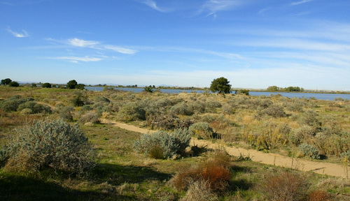
Giant sand dunes, later called the Antioch Dunes, were one of the notable natural features of eastern Contra Costa County. These dunes formed by deposits of glacial sands carried downriver from the Sierra Nevada before the development of the tidal wetlands in the Delta, and ranged from less than an acre to 25 acres in size. Some supported live oaks. Others may have been covered with grasses and other dune scrub vegetation. The eastern edge of the dunes was near present Antioch Bridge, where explorer Anza described camping near “a green grove of live oaks and oaks.” One early surveyor described the dunes as “in some places 100 or 200 feet high and covered with brush.”
The dunes were heavily mined beginning in the 1880s to produce bricks and asphalt, significantly lowering and smoothing them. Today the remnants reach only 50 feet above river level. (East Contra Costa County Historical Ecology Study, cited at the end of this essay. This study contains an extensive bibliography.)
A large swath of oak savanna grew east of Brentwood. There was an oak savanna in a small alluvial valley near present-day Marsh Creek Reservoir. The remainder of Los Meganos was grassland, woodland, chaparral and interior dune habitat. The areas of greatest woodland loss since the 1930s occurred in the upper Marsh Creek watershed, but from William Brewer’s description of the area, the landscape had greatly changed by the early 1860s.
William Brewer wrote in his Up and Down California in 1860-1864 (Library Reprint, University of California Press, 1975):
“I took my mule, to visit the hills eight or ten miles to the north and northeast of camp (Brewer’s camp on October 7 was in today’s city of Clayton, in the Marsh Creek watershed.). A very lonely ride, first through the Kirker Pass, then among rounded hills, almost bare of grass or herbage, in places entirely so – no trees to cheer the eye, no water in the many canyons and ravines.”
I found no source for the “they” Father Duran referred to in his diary that named the dunes medanos.
Father Juan Crespi, accompanying the Fages expedition to what is today Contra Costa County in 1772, also reached the Delta, camping at about – according to Bolton’s annotation – today’s Pittsburg, a little to the west of Antioch. The Fages expedition continued the next day on level land and halted on the bank of a small arroyo containing briny water. Bolton’s next annotation indicates they went over a range of mountains “north of Clayton,” and continuing west to Walnut Creek. The only pass they could have gone through was today’s Kirker Pass Road, which meant the went west to Walnut Creek generally following today’s Ygnacio Valley Road, a continuation under a different name of Kirker Pass Road.
The San Joaquin River runs along the dunes of the Stamm unit of the Antioch Dunes National Wildlife Refuge on Thursday October 29, 2009 in Antioch, Calif.
(Aric Crabb/Staff)
This means Fages did not reach Antioch and had either not seen the giant dunes or that Crespi did not note them because his interest was in figuring out that it was impossible to cross the very deep river without a boat. Crespi had written about the meganos on the coast about ten miles from San Luis Obispo in an unpublished diary. There are sand dunes on Spain’s coast and the Canary Islands. Franciscan missionaries left Spain from Cadiz, and would have seen the sand dunes on the Canary Islands.
If Crespi had seen medanos in Contra Costa County, he would have written about them.
The 1776 Anza expedition reached Santa Angela de Fulgino (Crespi’s name for today’s city of Concord) on April 3 and traveled through the plain and ascended Willow Pass and then went to the site of today’s Antioch Bridge, where they encountered a large village of Indians that greeted them “amicably almost fearfully,” according to Fray Font, who accompanied Anza.
Font’s diary for the day they were at Antioch does not mention sand dunes. No one on the expedition, however, could have missed seeing the dunes, however, so perhaps someone in the group of Anza explorers that first named the medanos.
Chapman’s A History of California: The Spanish Period contradicts his own suggestion in the same book that the Duran expedition was the first to name the sand dunes. He wrote in Chapter XXX that in 1776 Moraga crossed the San Joaquin River and went a day’s journey further on. “There were also pursuits of runaway mission Indians just over the hills and into the valley (the Central Valley), and certain vague explorations of the tulares.” By “tulares” Chapman meant the swampy areas of the Central Valley, where bulrushes grew, east of Antioch.
“A report of Lieutenant Hermengildo Sal in 1796 mentions streams which have been identified as the west, middle, and east channels of the San Joaquin…” Chapman subsequently listed several Spanish forays into the Central Valley, and at least some of them – one attacked by Indians – if not all had to have traveled either from San Jose or from the Mission Dolores or the San Francisco Presidio, which meant that for years before Fr. Duran rowed and/or sailed through the Carquinez Strait, they passed the sand dunes.
Alta California’s Governor Castro had granted the Rancho Meganos to Jose Noriega, but – according to Marsh’s biographer George D. Lyman (John Marsh, Pioneer: The Life Story of a Trail-Blazer on Six Frontiers, facsimile reprint of the 1930 book by Carol Jensen in 2012, Byron Hot Springs publisher, San Francisco) – Noriega was afraid to spend any time on his land in what is now Contra Costa County.
In 1837, the fierce Indians that lived in the Sierras and various bandits made living in the area perilous. Local Indians, however, built Marsh’s adobe house and brought him grapevines and fruit trees from the San Jose Mission to plant. Marsh had them build slots in the sides of the adobe so that he could insert a rifle when he needed to shoot at bandits and cattle rustlers.
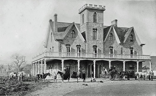
John Marsh House, Marsh Creek Rd., Byron, CA
Marsh installed an Indian woman in his house as his mistress and housekeeper/cook. Lyman does not mention what happened to the Indian mistress possibly a Julpunes, after 1850, when Marsh began construction on his big stone house. Perhaps the woman stayed on and to do the cooking and cleaning. Perhaps Marsh gave his native common law wife some glass beads and let her return to her village.
Lyman explained in John Marsh, Pioneer that Marsh paid natives in glass beads and red cloth to mine gold for him during the Gold Rush – gold that he subsequently hid, and which no one has found.
Marsh paid his Indian laborers in beans and tortillas and he sometimes paid his Mexican vaqueros wages. When one of the vaqueros threatened to sue him for wages, Marsh told him he couldn’t: he was a “nigger.”
Although under Mexican law, dark-skinned men had equal civil rights with lighter skinned people, American law in 1850 barred African-Americans from testifying in court against whites.
Marsh, however, was probably incorrect because the Treaty of Guadalupe Hidalgo (1848) accorded everyone who had been a Mexican citizen the same civil rights as those people born in the United States. Former Mexican citizens, no matter their skin color, were “white.” Marsh had been a justice of the peace on another frontier and was highly literate. He probably insulted his vaquero simply because Marsh was often – but not always – a nasty man.
He refused to marry into a Mexican land-owning family to acquire cattle, the way that other foreigners had done. He sneeringly referred to the Mexican people as “greasers” and said he wanted to marry, when he married, one of his “own kind.” Considering the facts of his earlier experiences, he probably did not have real racial antipathy but wanted to infuriate his neighbors.
Marsh’s son Charles was his child from a common law marriage to a French-Indian woman when he lived in Missouri. Marsh had been at one time a “squaw man,” and his son was one-quarter Indian. He protested the American government’s treatment of the Sioux people. His work as a doctor in Los Angeles meant that all of his patients were Mexican citizens. He allied at various times politically with Mexican citizens in various intrigues.
That is, he may well not have been a racist, but he was frequently rude and insulting.
Marsh got cattle in exchange for his work as a doctor. He spent his evenings drinking brandy and reading over and over the books and papers he had brought with him. Marsh had a degree from Harvard, although not in medicine. Although he was not an M.D., the Mexican government authorized his practice of medicine after the padres in the San Gabriel Mission translated his Harvard degree.
Bandits, wild Indians, the Mexican government’s brief imprisonment of him for attempting to create a revolution by bringing in Americans, and his participation in his former friend Johann Sutter’s involvement in Alta California’s political battles – real battles with guns — troubled his days.
Ygancio Valley Road runs along the approximate border of the city of Clayton and the city of Concord. This road turns into Kirker Pass Road.
Marsh hired James Kirker, mountain man and Apache scalp hunter to help defend Los Meganos. (See, William E. Mero, “Myths, Legends and Facts: the Final Days of James Kirker,” http://www.cocohistory.org/essays-kirker.html. Retrieved 9/20/2016).
Marsh married Abigail Smith Tuck in 1851, when she was thirty-three years old. Abigail had been a schoolteacher in Santa Clara when they met. She wrote to her sister in 1851:
“…I concluded (sic) to stop a few weeks with Mrs. Appleton a lady with whom I used to board. She promised to take me on a pleasure trip over the mountains into the San Joaquin Valley. This trip promised to be quite an interesting one. The first day we came about twenty-five miles. The next morning we started early and wandered among the mountains. About sunset we came to a bachelor’s rancho, but no one was at home. We had seven or eight miles further to go but did not know which way it was …. Then returned to the bachelor and found him home and glad to see us. He was an acquaintance of Mrs. Appleton’s. We stayed with him all night and the next morning completed our journey.
“The bachelor has been out here sixteen years. He is about fifty years old and is a graduate of Cambridge College. I like his appearance and have since become further acquainted with him. His name is Doctor John Marsh & he is none other than your brother-in-law. We were married on the 24 of June. Our acquaintance was short only a little more than two weeks but I had (no) risk to (run) and is worthy in every respect …I feel that my roaming is at an end – I have some one to love and care for me and who has enough of this (material) goods to satisfy every reasonable want. I expect to spend my days here.” http://johnmarshhouse.com/john-marsh/marshs-family/. (Retrieved 9/28/2017.)
They had a daughter a year later. Abbie died in 1855, probably of tuberculosis. Marsh at first was unable to return to his adobe and the stone house was incomplete.
“I have for the last two months been residing in (San Francisco) only going home occasionally,” he wrote to Abby’s parents. “Indeed it seems to me that I have no home now…”
During the last fifteen years of his life, Marsh started the westward movement of wagon trains to California, intending explicitly that Americans would take over the state.
“(H)e increasingly wanted to see California come into the possession of the United States, and almost every wagon train to the east carried letters to his friends praising the glories and possibilities of the land. Most of these letters were to Missourians and were published in Missouri newspapers.
“These letters, written from direct observation, exerted a far reaching influence on immigration to California, especially from Missouri. Their influence, coupled with the practical efforts of Antoine Robidoux, probably helped the movement that resulted in the first emigrant party to California via the Rocky Mountains and the Sierra Nevada, led by Bidwell and Bartleson in 1841.” (Historic Spots in California, 3d edition)
Bidwell — who later traveled to Washington, D.C. to ask Abraham Lincoln to sign documents to incorporate California as a state in the union — arrived at Los Meganos after a dismaying journey on the California Trail, a journey made at Marsh’s invitation.
The California Bidwell saw was scarred with drought and looked nothing like the land Marsh had promised. Marsh at first was an agreeable host, but Bidwell was to thereafter refer to Marsh as the meanest man in California.
Bidwell was working for Sutter when gold was discovered on the Feather River – John Marsh had earlier named the river Las Plumas after finding a stretch of it covered in feathers – and established a productive claim on Bidwell Bar. He bought Rancho Arroyo Chico on Chico Creek, which the city of Chico presently occupies. He was a Republican member of Congress from 1865-1867. In 1892, Bidwell was the Prohibition Party candidate for President of the United States.
Marsh was murdered either because he did not pay his vaqueros or because he got into a lawsuit with a neighbor and won.
Ygnacio Sibrian establish Sulpher (sic) Springs Ranch around today’s Heather Farm Park and the John Muir hospital center on Ygnacio Valley Road. Sibrian built the first roofed house in what became known as Ygancio’s valley. As you follow Ygnacio Valley Road into Walnut Creek, you will probably smell the sulphur spring.
Marsh contracted with Sibrian to brand Marsh’s cattle but Marsh refused to pay Sibrian the amount demanded for the work. According to Lyman’s research, Sibrian lost his lawsuit against Marsh shortly before Marsh’s murder but the court record indicates Sibrian assigned his claim nine months before the murder. (Pacific Reports, California Supreme Court, January term 1858, page 130, et seq.).
It took years to find two of the murderers. After his capture, he claimed, according to Lyman, that Sibrian paid them $300 to kill Marsh. On the other hand, Marsh’s biographer also includes testimony that the murder was over unpaid wages. Ygnacio transferred his Sulpher Springs Ranch in 1879, so he probably was not prosecuted. The other murderer spent a very long time in prison but when he got out, he mysteriously had a great deal of money. Maybe he got out of Marsh where his gold rush money was hidden before he killed him – or maybe the gold is still buried somewhere in Brentwood.
As you drive up Clayton Road from Concord the sign reads: “Ygnacio Valley Road “on the bottom of the sign and “Kirker Pass” on the top The names of Marsh’s hired bandit-fighter and the man that may have arranged Marsh’s murder join on a sign between two shopping centers in a bland suburban landscape. The junction is also very likely a portion of the road that the Fages expedition took to reach today’s Walnut Creek about 250 years ago.
Contra Costa means the opposite coast. It was the coast on the bay opposite the Presidio and the mission in San Francisco and then opposite them and the very tiny settlement of Yerba Buena, which became San Francisco.
In a region where grasslands rippled like an emerald sea in spring winds, divided by arroyos, distinctively marked by enormous sand dunes and by the Delta marshes and dominated by towering Mt. Diablo, inhabited by mild native people, then a few Mexican families, vaqueros that were mixtures of Indians and descendants of Africans and a disagreeable, extraordinarily mean, highly literate, lonely man who created for himself a baronial estate and from the site of Los Meganos wrote the letters that began American California.
Suggested visits:
The Antioch Dunes National Wildlife Refuge offers docent-led tours every second Saturday of each month. What is left today are two unconnected parcels containing sand dunes varying from 0-50 feet in height.
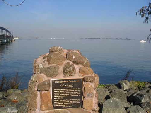
Anza Expedition Campsite 101 next to Antioch Pier
The Delta de Anza Regional Trail is 14 miles long, running between Willow Pass Road at Route 4 near Concord and Main Street to East Cypress Road in Oakley.
Marsh Creek Trail follows Marsh Creek through the outskirts of suburbia into rich farmland between Concord Road in Brentwood and Big Bear Lake.
John Marsh Historic Park, 21789 Marsh Creek Road, Brentwood, California.
Selected sources:
Herbert Eugene Bolton, Anza’s California Expeditions, Vol. III, University of California Press, Berkeley, California 1930).
Herbert Eugene Bolton, Fray Juan Crespi, Missionary Explorer on the Pacific Coast (Hardcover copy, AMS Press, 1978. The original book was published by University of California Press, Berkeley, California, 1927).
The Honorable A.F. Bray, “Indian Slavery In Contra Costa County.”
http://www.cocohistory.org/bray-38-02-22.html. (Retrieved 9/3/2016)
Charles E. Chapman, A History of California: The Spanish Period (Macmillan 1924)
John Hart, “The Once and Future Delta: Mending the Broken Heart of California,” Bay Nature, April 1, 2010. http://baynature.org/article/the-once-and-future-delta/. (Retrieved September 3, 2016).
Henry G. Langley, editor, Historical and Statistical Review of San Francisco, San Francisco Directory, September 1862. http://www.sfgenealogy.com/sf/history/hg862.htm#Annals of San Francisco (Retrieved September 24, 2016).
Kay Maldetto, “William Richardson and Yerba Buena Origins,” Shaping San Francisco’s
William Mero, “Bandits, Brentwood and the Wild Frontier,” January 2014. http://johnmarshhouse.com/bandits-brentwood-wild-frontier/.
Harry C. Meyers, “A History of the Santa Fe Trail.” Santa Fe Trail Association, 2010. http://www.santafetrail.org/the-trail/history/history-of-the-sft/. (Retrieved September 2, 2016).
National Park Service, “Travel the Trail: Map Timeline 1821-1845” at https://www.nps.gov/safe/learn/historyculture/map-timeline.htm. (Retrieved 9/2/2016).
National Park Service, “Old Spanish National Historic Trail New Mexico, Colorado, Utah, Arizona, Nevada, California.” https://www.nps.gov/nr/travel/cultural_diversity/Old_Spanish_National_Historic_Trail.html. (Retrieved 9/2/2016)
Old Spanish Trail Association. http://www.oldspanishtrail.org/. (Retrieved 9/2/2016).
San Francisco Estuary Institute, East Contra Costa County Historical Ecology Study. http://www.sfei.org/sites/default/files/biblio_files/East_Contra_Costa_Historical_Ecology_Study_Final_(lowres)_0.pdf. (Retrieved September 23, 2016).
Comments
Leave a Reply
You must be logged in to post a comment.
Honey on the road to San Francisco with some of the Spanish explorers
NOTES FROM ABOVE GROUND
By Honey van Blossom
(Honey is a Belgian Marxist former strip-tease artiste)

"Cities of the Golden Gate," Raymond Dabb Yelland, 1893. Most illustrations can be enlarged by clicking on them.
Prologue to the story of the Spanish exploration and settlement of California
Seasonal migrations of animals now extinct in California probably created the roads the native people used before the Spanish land exploration of California. “The heyday of giant mammals in North America was the middle and late Pleistocene, an epoch that started 2.6 million years ago and ended 11,700 years ago, around the time the Earth was thawing out from the Ice Age. The gigantic beasts, which migrated from Asia across a now-vanished land bridge called Beringia, are known as Rancholabrean megafauna, after the famous La Brea tar pits in downtown Los Angeles — the graveyard of thousands of saber-toothed tigers, giant bison and other extinct animals.”[1]
The seasonal migrations of the large mammals may have created the substantial roads used by the indigenous people after their arrival.[2]
Paul S. Martin and Richard G. Klein argue that Paleoindian over-hunting led to the extinction of the megafauna.[3] Others argue that climate change was responsible for mammoth and mastodon extinctions. As the last major glaciation ended around 12,000 years ago, climate warmed too quickly for the megafauna to adapt.

