
Honey’s search for El Portezuelo
NOTES FROM ABOVE GROUND
By Honey van Blossom
(Honey is a Belgian Marxist former strip-tease artiste)
[In order to see the detail of the maps and some of the larger photos, you can click on them to see the full size.]
Introduction
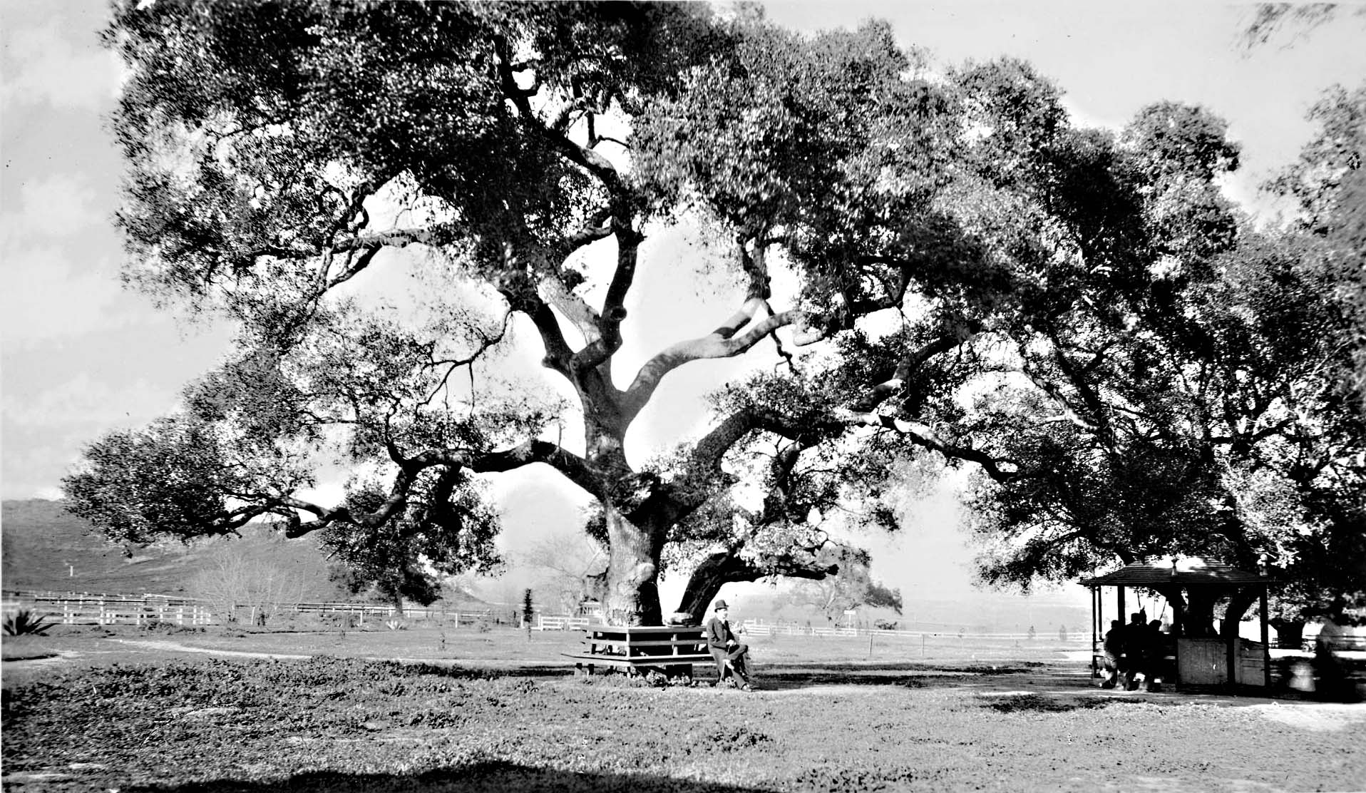
A Huntington Digital Library cataloger wrote that the scene in the photograph of a man sitting under the boughs of a tree was taken at the Ostrich Farm in Griffith Park.
According to Mike Eberts, Griffith J. Griffith’s Ostrich Farm was located near today’s Crystal Springs picnic area.[1]
Mike Eberts was right. The Huntington cataloger was wrong.
The Man Sitting Under Tree Boughs photo shows Beacon Hill, the eastern-most summit in the Santa Monica Mountain Range, the 1,001-foot hill that towers over the Los Angeles River. Beacon Hill separates Crystal Springs from the Riverside Drive portion of Griffith Park.
You can see Beacon Hill from the Crystal Springs side but the hill does not look the same from the Crystal Springs side.
CHS Collection, USC Library
The USC cataloger, on the other hand, stated in her description of the Man Sitting Under Tree Boughs photo on the USC Digital Library site that the photograph was taken in Griffith Park and could be near Crystal Springs.
The USC cataloger might be partly right; that is, the tree could be near the strip of park along Riverside Drive, the part with the swimming pool and the GPPAC module and parking lot, although – if he was near that strip of park — the leafy boughs he sits beneath would be about where the William Mulholland Memorial Fountain (popularly known as the Kool-Aid fountain because the colors of the electric lights illuminating the water change from purple to red to orange to yellow to green) is today. That location is about a mile or so downriver from Crystal Springs.
The hill in the background of Man Sitting Under Tree Boughs looks bare, which gives a clue about the year the picture was taken.
Ervin King, in “Boys’ Thrills in Los Angeles of the ‘70s and ‘80s,”[2] described a time when the hills were not as bare as they were in Man Sitting Under Tree Boughs:
“Native trees, shrubs, and vines in rank profusion, overhung the narrow dirt wagon trail. Flowers and insects showed their colors, while across the road sometimes scurried a rabbit, squirrel, a covey of quail, a lizard or a snake. Then came the ‘caw caw’ of cross, a shrill hawk cry, or that of a blue jay or yellow hammer, and the ‘tap tap’ of woodpeckers, with quail calls, mourning dove notes and squirrel squeaks.”
The fire of 1879[3] may have damaged the oak trees on the hills.
Also, Griffith J. Griffith donated the park to the City in 1898.[4] On March 26, 1902, Griffith complained in a letter to the Mayor and the City Council that “even the beautiful trees …have been ruthlessly destroyed and marketed for fuel” at $1 per wagon load.[5]
That the hill behind the large tree in the photo of the man sitting under tree boughs looks bare suggests it was taken sometime after Griffith donated the park — rather during the Ostrich Farm years — so possibly taken in the later 1890s or early 1900s.
In a USC master’s thesis, Elisabeth Mathieu Spriggs wrote, “Until 1881 Mulholland lived in a ‘shack’ near the Old Sycamore Tree. This historic tree, which was used in early deeds and records, stands at the extreme south end of Griffith Park at the intersection of Riverside Drive and Los Feliz Boulevard.” [6] Mulholland signed a letter bound in with Spriggs’ thesis and no doubt knew where he lived but he may not have known the names of trees that well.

William Mulholland
If the man in Man Sitting Under Tree Boughs was Mulholland, then he returned to the location after he lived there to have his picture taken.
The location of the tree may have been near to today’s Hyperion Bridge,[7] depending on whether the day the photograph was taken was hazy or clear but the man sitting under the boughs of a big tree probably was where the Mulholland Memorial Fountain is; that is, at the intersection of Riverside Drive and Los Feliz Boulevard.[8]
The location of the tree in the photograph may be a piece of the puzzle of the location of an area once called El Portezuelo.
In February 1776, Juan Bautista de Anza brought colonists for the San Francisco Presidio through Los Angeles and camped at a location he and the expedition’s diarist Father Font called El Portezuelo. A year later, the pueblo of San Jose was founded and, in 1781, the Los Angeles pueblo.[9]
Figuring out where El Portezuelo was on today’s map depends mostly on where the roads were. Anza didn’t crash through chaparral. The members of the expedition rode horses, muleteers walked alongside heavily laden mules, and roads determined how they got from place to place.
The Indians did not build in straight lines. The roads they inherited –from the mega-fauna extinct about 3,000 years after the Paleo-Indians arrived in Southern California — meandered where creeks and springs flowed and around hills.
The vecinos — like the native people that had dominated the land before them and that later did all the labor for them– were in no hurry to get anywhere or do anything. They were where they wanted to be all of the time.
The Americans that arrived after 1850 were by the 1870s engineering crazies. They treated the Los Angeles hills and valleys like a big set of children’s Play-Doh – combining and straightening ancient roads, boring holes through the hills for tunnels, pulling oil out of the ground, slicing through hills, filling ravines, building bridges.
It is not easy to reconstruct Los Angeles’s eighteenth-century terrain and the roads through it.
Wherever El Portezuelo was, that spot was the stopping place for the San Francisco colonists and it may have been a stopping place for Father Serra, Governor Neve, and for the Santa Barbara and San Jose colonists.[10]
The several meanings of the term “El Portezuelo”
First possibility: El Portezuelo meant the Glendale Narrows
According to Josiah D. Whitney[11]’s Names and Places Studies in Geographical and Topographical Nomenclature (Cambridge University Press 1888), at page 141:
“The summit of the pass is called the divide or water-shed. In this last word the ‘shed’ has not the present meaning, but an obsolescent one of ‘part’ or ‘divide’…. Skeat says: ‘The old sense to part is nearly obsolete, except in water-shed, the ridge which parts river-systems…. The ‘water-shed’ of any river basin limits its ‘area of catchment,’ as the hydraulic engineers call it. Portezuelo, also spelled ‘portachuelo,” is the Spanish for ‘divide’” and this word is – or was, a few years ago – in current use among English-speaking people in parts of the California Coast Ranges.”
Portachuelo today means an opening between two mountains, a pass, or a gap.
El Portezuelo may have originally referred to the entire area divided by the Los Angeles River that passed between the Santa Monica Mountains and the Verdugo Mountains. The river through that large area is called today the “Glendale Narrows,” which begins on the western side at Griffith Park and on the eastern side at today’s Burbank and goes almost to the Broadway Bridge downtown.
The Los Angeles River begins at Bell Creek and Arroyo Calabasas. At the sharp bend where it curves around the last hill in Griffith Park, it receives water from the Verdugo Canyon Wash, which drains La Canada Flintridge and Glendale as it flows from the San Gabriel Mountains through a water gap in the Verdugo Mountains, 2.0 miles northwest of Glendale.[12]
On the eastern side, the river water in the Narrows passes a little of the cities of Burbank, Glendale, and the Los Angeles districts of Glassell Park, Atwater Village, Highland Park, Lincoln Heights, and Cypress Park.
On the western side of the Narrows, the river passes Griffith Park, the Los Feliz district, the Silver Lake District, the back of the Echo Park district, Frogtown (the Elysian Valley), and Elysian Park. Within the Elysian Park hills is Dodger Stadium — which was before it was the ballpark, the three communities of Chavez Ravine developed by Julian Chaves in 1860 — the police academy, the site of the first Jewish cemetery, and the Solano Canyon neighborhood.
Blake Gumprecht described the hydrological and geological sources that contributed to the Los Angeles River:
“Most of the water that percolates into the aquifers beneath the San Fernando Valley originates in the San Gabriel Mountains.”[13]
The San Fernando Valley aquifer has the capacity to store one trillion gallons. “Seasonal rains quickly saturate the shallow mountain soil, and water runs off rapidly, draining into hundreds of mountain canyons that feed three principal streams – Big Tujunga, Little Tujunga, and Pacoima Creek.”[14]
The area where the river bends around a hill in Griffith Park and then turns south fits the descriptions of both Whitney’s “divide” and also fits the other meanings of “gap,” “pass,” and “pass between two mountains.”
GLendale, 1870s, Water & Power Associates.
This is a view of Glendale sometime around 1870, seen from Griffith Park. The river may be that white sinuous band through the middle of the photograph. The smaller mountain range is the Verdugo Mountains and the “Snowy Mountains” behind is the San Gabriel Mountain Range.
Second possibility – the name was Fr. Font’s name for the place they camped. The name gently suggests Font considered their journey was quixotic.
E. Bolton placed the campsite at a logical place if El Portezuelo meant the Narrows, meaning both a gap between two mountains — the Verdugo Mountains and the Santa Monica Mountains — and the geographic divide. He did not, however, footnote or otherwise explain why he thought Anza would have named the place El Portezuelo. He assumed the campsite had to have been located in a place named El Portezuelo in a place where a reasonable person – and H. E. Bolton was an earnest academic that interpreted events in the history of the Spanish borderlands reasonably.
Alan Brown’s translation of his relationship with Anza in Font’s diary reveals Font as a witty eccentric who engaged in playful banter, especially with Anza. Font was a card.
Font referred to today’s San Fernando Valley as Santa Isabel. Brown, in a footnote wrote that was probably a mistake. Crespi had named the valley Santa Catalina.
Santa Isabel was the mother of Juan el Bautista. Anza’s name was Juan Bautista de Anza. Font did not make a mistake: he was pulling Anza’s leg, an exercise he often undertook.
“Portezuelo” may have been a reference to The Ingenious Nobleman Sir Quixote de la Mancha by Miguel de Cervantes, which mentioned “portezuelo” as “a gate (portezuelo) or house” on the banks of “los ginoveses” fished for coral.
“El Portezuelo” could have been Font’s private joke with Anza that simultaneously meant Anza was Don Quixote, that Font was Quixote’s side kick, that the entire venture of settling San Francisco was quixotic, and also that the campsite was a gateway to the banks of the Los Angeles River.
Third possibility: the campsite Font and Anza called El Portezuelo meant one of the passes between hills that reached the Narrows on the western side of the river
The coccyx of the Santa Monica Mountains is Elysian Park (The City established the park in 1886 from the hills formerly called Stone Quarry Hills.).[15] Bits of this range that begins in the west at Pacific Palisades, and which divides the San Fernando Valley and everything on the downtown side (Downtown, Hollywood, the Hollywood Hills, and West Hollywood) may be seen from the Griffith Park Observatory: the most obvious are the Los Feliz hills and the higher Silver Lake hill realtors call “Moreno Highlands” and sometimes “Silver Lake Heights.” Hyperion Boulevard runs through the gap between those hills, a gap excavated about 1920 through Waverly Heights.
“Waverly Heights” and “Silver Lake Heights” are smaller rises. The Echo Park hills are on the same grouping of hills as Elysian Park.
The green watered Forest Lawn hill may be seen from the observatory on the eastern side of the river, as may be seen the hill between Eagle Rock and Highland Park. Further to the south on the eastern side are the hills of Cypress Park, Elephant Hill, the Eugene C. Debs park, Boyle Heights, and Lincoln Park.
Anza crossed the river just below the Narrows at about where today’s Broadway Bridge is. The 1769 Portola expedition had crossed the river at that point on August 3, 1769. That location was also where the first settlers from Mexico would ford the river in 1781 to establish the first Spanish village in the Los Angeles pueblo.
The 1776 San Francisco Colony travelers continued their journey after crossing the river on the road from the San Gabriel Mission, which means that none of the gaps between hills on the eastern side of the river are candidates for what Font and Anza meant when they wrote they stopped for the night at El Portezuelo.
The primary candidates for El Portezuelo are: the land area where the Los Angeles River turns south at the end of today’s Griffith Park (H.E. Bolton’s conclusion); Crystal Springs (because its first name may have been Lago del Portezuelo), the area between Los Feliz Boulevard and Riverside Drive, which is a corridor of land between the Los Feliz hills and the Santa Monica Mountains (“Muangna”); the corridor between the Los Feliz hills and the Silver Lake hills along Griffith Park Boulevard and Hyperion Boulevard; and the meadow with a creek running through it that became the Silver Lake Reservoir in 1907.
Those that contend El Portezuelo was a bit to the west of the Feliz boundary– in the Cahuenga Pass – partly base their position on the meaning of El Portezuelo as “a pass”; that is, that the Indian road through the Cahuenga Pass was obviously a mountain pass.
Clues from the three branches of El Camino Viejo on E.O.C. Ord’s 1849 La Plan de la Ciudad de Los Angeles.
The Indian road that left Yang-Na a short distance to the west of today’s “La Placita” — the first completed Catholic Church (completed in 1822) – at today’s West Temple followed West Temple and then branched to the west. Those three branches together were once referred to as “El Camino Viejo.” The three branches are visible on E.O.C. Ord’s 1849 La Plan de la Ciudad de Los Angeles.
Santa Monica branch of El Camino Viejo
Portola followed that first branch past the La Brea Tar Pits to that expedition’s second campsite at the location of today’s University High School.
Anza did not go to Santa Monica; he did not choose the branch that went west.
Two other branches remained. He could not have left Los Angeles and headed towards San Francisco by any other way because there was no other way; there was only El Camino Viejo, an ancient Indian road with three branches.
Cahuenga Pass branch of El Camino Viejo
A branch of El Camino Viejo went through today’s Hollywood to the Cahuenga Pass. This is the route Portola followed on that expedition’s return trip in January 1770.
This branch led from the plaza to the extensive lands possessed by the San Fernando Mission (1797) — lands that occupied much of what is today the San Fernando Valley. The turn of the twentieth century map showing the three main ranchos shows how large the mission lands were is below. The Cahuenga Pass may be seen towards the bottom right. Next to the Cahuenga Pass is a band with the words “Griffith Park” and “Rancho Los (Feliz).”[16]

Early San Fernando Valley map. NEW: Click on all the maps to see a larger size.
The Cahuenga Pass route was to become the most popular route to the San Fernando Valley from the plaza downtown by the time of the American era. It is now the segment of the 101 Freeway called the Hollywood Freeway.
There was water in the area of today’s Fern Dell – if water were the only determining factor in Anza’s choice of route – and have been a good choice except for the lack of pasture but, in that case, Anza would have camped in Fern Dell and not in the Cahuenga Pass.
According to Mike Ebert in his Griffith Park: A Centennial History the council grounds of the Gabrielinos was the Mocochuenga council grounds.[17] City of Los Angeles landmark #112 states the council grounds were in Fern Dell, which, actually, is not in the Cahuenga Pass. There may well have been an Indian village in Fern Dell; however, evidence of this murky. Also, Fern Dell is not in the Cahuenga Pass.

Cahuenga Pass in 1890s. Water and Power Associates.
The authorities Ebert cited in his bibliography are weak in archeological evidence. Bernice Eastman Johnston pointed out that Hugo Reid identified the Rancheria of Cahueg-na, and that other references may be found in A.L. Kroeber’s map of California Indians.[18]
Bernice Eastman Johnston also stated “Portezuelo” meant “Little Door,” and that it represented the Cahuenga Pass. Portezuelo does not mean “Little Door” in Spanish. Portezuelo does not seem to have had any Tongva root, and it would be weird if an old Iberian Peninsula word meant something similar a very old Tongva word. She stated the “Little Door” — Cahuenga Pass –was “El Portezuelo.”[19] Eastman did not indicate why she thought that, and there is no evident source for her conclusion in her bibliography.
The third branch of El Camino Viejo turned northeast through the hills that embraced the plaza area.
The most likely route that Anza followed was the third branch of El Camino Viejo — the branch that went through a pass in the hill and then through the Arroyo de los Reyes (Echo Park Lake) to the campsite Font and Anza called El Portezuelo.
A copy of an 1843 map – the tracing was made in 1865 — Diseño[20] del Rancho Los Felis[21] included sketches of several trees near the lake. They were probably oaks. This area around the lake became a marsh by 1868, and about then known as Crystal Springs.[22] Today it is the Crystal Springs picnic area in Griffith Park.
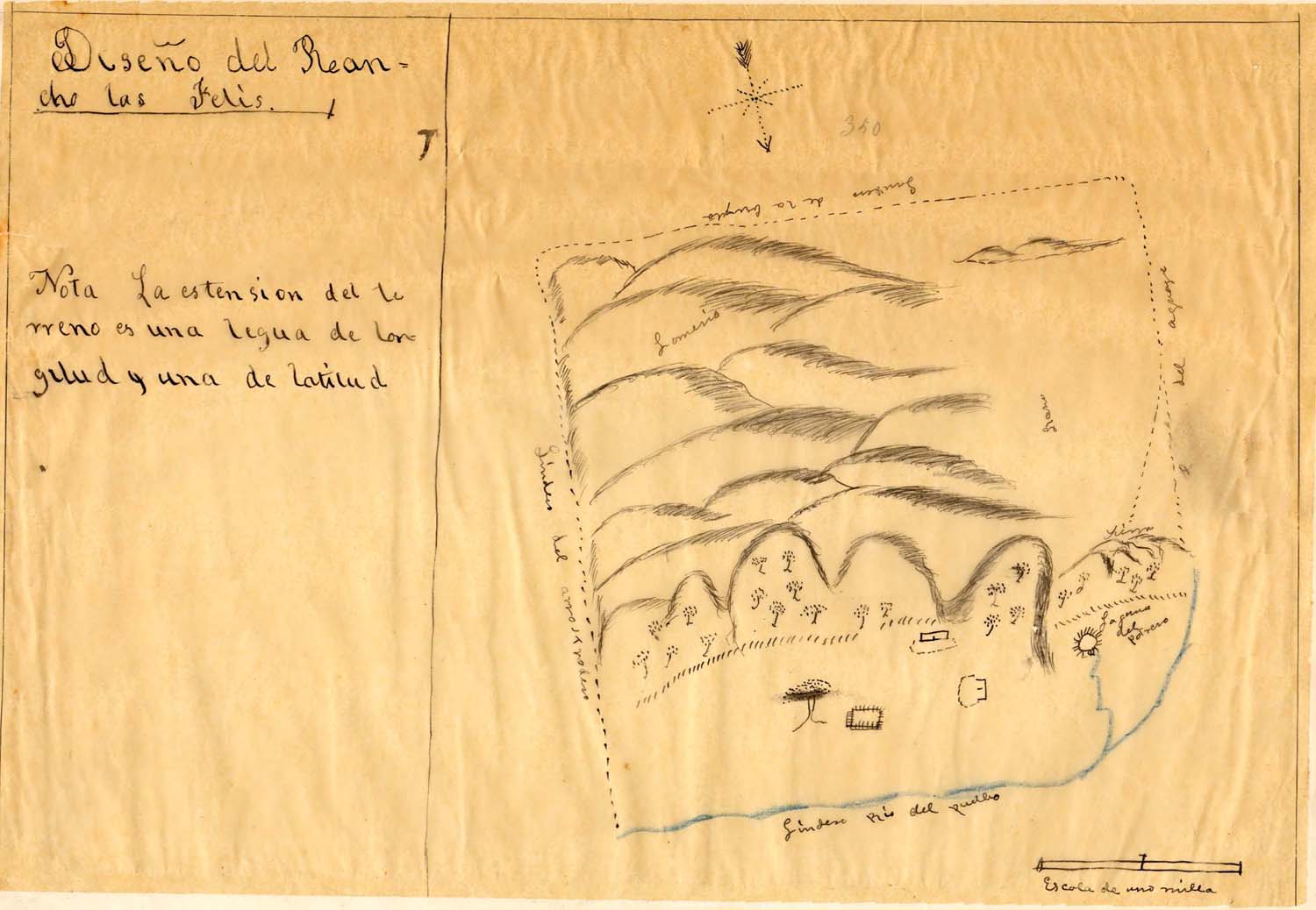
1843 map
The maps and surveys in this essay are footnoted with links to the digital libraries. The digital libraries allow researchers to expand the maps to 100% so that the areas described in the documents may be seen full-size.
The various possibilities of the word next to the lake in the 1843 map are “Polrero,” or “Potrero” or “Porerero.” None of those words are Spanish or English words. Either the person tracing the map incorrectly copied the words in “Laguna del Poltrero” (or Polrero or Porrero), or the word in the original was garbled.
The most likely name for the lake was Laguna del Portezuelo – Lake of El Portezuelo.
Towards the bottom of the lake, next to what looks like a rectangle with scratched lines is a drawing of a very large tree – unlikely to be the big tree in Man Sitting Under Tree. The rectangle was probably the first Feliz ranch house. The “linden del Arrastradero” is a fairly short distance from the big tree.
The Los Feliz Rancho became Griffith Park, the Los Feliz District, most of the Silver Lake District, and an edge of Frogtown
Griffith Park is a large portion of what was once the Feliz Rancho. The rancho – granted to José Vicente Féliz y Esquer by Spanish Governor purportedly in 1795[23] — included as well today’s large municipal park, the areas in today’s largely residential Los Feliz District, and a large portion of today’s largely residential Silver Lake District. On the western side, the rancho ended just above the Cahuenga Pass about where Universal Studios is now.
After Mexico gained independence from Spain in 1821, California was a Mexican province. Mexican Governor Micheltorena confirmed the grant in 1843. After the cession of California to the United States following the Mexican-American War, the 1848 Treaty of Guadalupe Hidalgo provided the land grants would be honored. In 1863, Antonio Coronel acquired the rancho, and he sold a portion of it to James Lick.
In about 1882, Griffith J. Griffith purchased what remained of the Feliz Rancho. He bought back land that had been subdivided before 1882, and, in 1892, he donated the largest part of the Feliz Rancho to the City, even though it was not actually in the City until 1910.
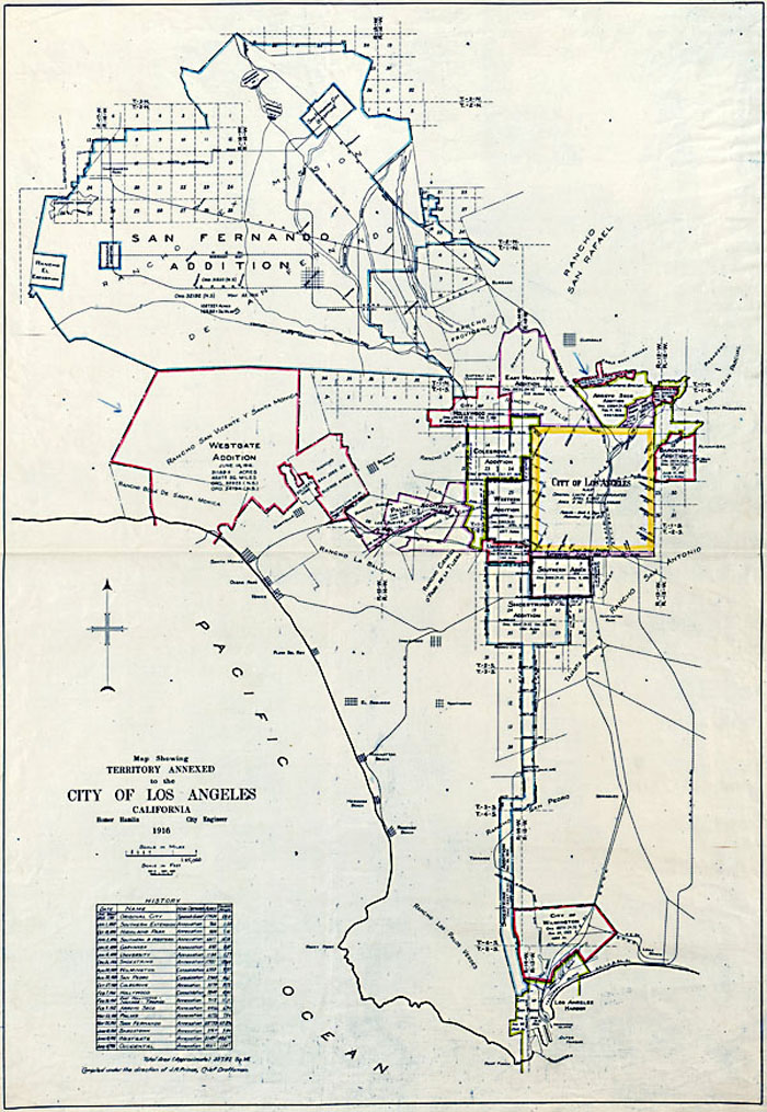
Annexed to Los Angeles map. [24]
The annexation map shows the Rancho Los Felis, including Griffith Park, was the “East Hollywood Addition” as of February 28, 1910. The City of Los Angeles (the original municipal boundary) went as far West as Hoover Street before 1910. Micheltorena Street (probably created in about 1886 as part of the creation of the paper town of Ivanhoe), which now ends suddenly at the 101 Freeway, went through Sunset Boulevard – as it does today – but the annexation map did not show topography, so did not show how steep Micheltorena Street was and is.
Annexation meant that 1880s Boomer era plans could at last be implemented: the Feliz Rancho lands were under City auspices and under the control of the City Council.
Robert Fogelson, in his Fragmented Metropolis, pointed out that City planning, commenced in the Progressive era, “far from guiding the expansion of the metropolis, merely sanctioned the preferences of private enterprise.”[25]
El Portezuelo on Rancho Feliz
An 1871 map, “Plat of Rancho Los Feliz, line from Nopalero (Nopales grow on cactus) to Portezuelo [26] shows “Encino in Puerta Suela.” Encino means oak tree. The oak tree is, once again, probably the oak tree in the photograph. “Puerta” means “door.” “Suela” means the sole of a shoe. It most likely meant oak in the Portezuelo.[27]
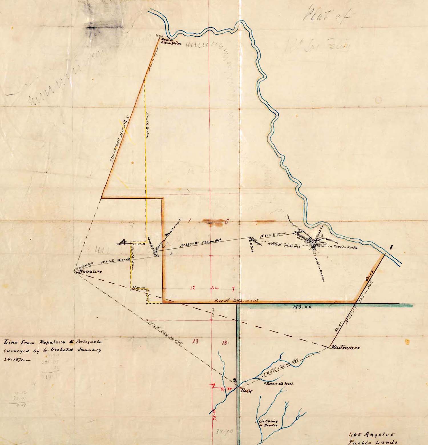
Plat of Rancho Los Feliz
In 1887, a document referred to as a survey was an imaginative survey by developers of a proposed subdivision of the eastern portion of the former Lick property.[28] That is, the property formerly part of the Feliz Rancho that Antonio Coronel transferred to James Lick.

Map of Ivanhoe.
This was the 1887 proposal for the town of Ivanhoe.[29]
This subdivision of Ivanhoe was not developed in 1887. It was one of the “paper towns” – towns that only existed on paper during the Boom of the 1880s, after Southern Pacific Railway arrived in Los Angeles in 1876. The Boom collapsed, and the paper towns were not developed.
After the river was channelized, its route was changed but — before the I-5 was built — the land area closer to the present river was larger than it is today. There had been a children’s playground and a grassy area after that to the river’s edge until 1960. This area that includes the swimming pool is part of Griffith Park. It is therefore publicly owned. It was also before 1960 when the “Golden State” Freeway (I-5) bit out a big chunk, larger than it is today.
The Lick portion of the Feliz Rancho started at the slanted line that read “Puerta Suela.” According to Glenn S. Dumke,[30] Ivanhoe was situated on the Los Feliz Rancho, “comprising the eastern portion of the Lick Tract; it was recorded June 2, 1887.”[31]
This town was not developed, but some of the street names for the proposed town at some point became the street names used today[32]:
The centerpiece of Ivanhoe was to be the “L.A.C. Reservoir,” which Mulholland would build as a reservoir in 1907. It is no longer a reservoir but the first segment of it is still referred to as the Ivanhoe Reservoir. This is today’s Silver Lake.[33]
The Ivanhoe survey or map shows the route of the Ostrich Line, which, on this map, ends as it enters the Coronel portion of the rancho. The route of the Ostrich Farm train on this map was shown as along today’s Griffith Park Boulevard. In the 1920s Walt Disney built a studio – where Snow White would be animated — at the corner where the Ostrich line crossed over Hyperion to continue its way to the Coronel portion.
Waverly is a street at the top of a hill that descends to Riverside Drive, and it crosses to another hill along a bridge over Hyperion. The street on the map designated as “Woodstock” on the Ivanhoe survey is today Riverside Drive.
The “Puerta Suela” area on the 1871map was a distance from the river. Measuring the distance from the known location of 4370 Crystal Springs Drive – the “new” Feliz ranch house – to today’s Hyperion Avenue before it crosses the bridge into Atwater – matches the distance on this map to the oak and the “Puerta Suela.”
Assuming the 1868 designation is correct and the measurements are correct, the Puerta Suela – probably Portezuelo – was an area to the south-southwest of the river in the “part of Lick” – and it was at somewhat of a distance inland from the river.
The 1868 map did not show the topography of the area. The hills that are here now are the hills of 1776, except that the Waverly Hill (in the Ivanhoe map) was one continuous hill until sometime between 1921 and 1928 when the City dug through the hill, dividing it so that Hyperion was extended to enter the Hyperion Bridge (1928).
A bit of the original Los Feliz Rancho is missing from a corner of the Ivanhoe map near the top. Julian Chaves, Mariano Chaves, and Juan Bouet had farms below the Rock Quarry Hills (Elysian Park), and part of the Juan Bouet tract near Rattlesnake Park on Fletcher Drive extruded into the Feliz Rancho. The three parcels are today’s Frogtown.
Map of Frogtown.
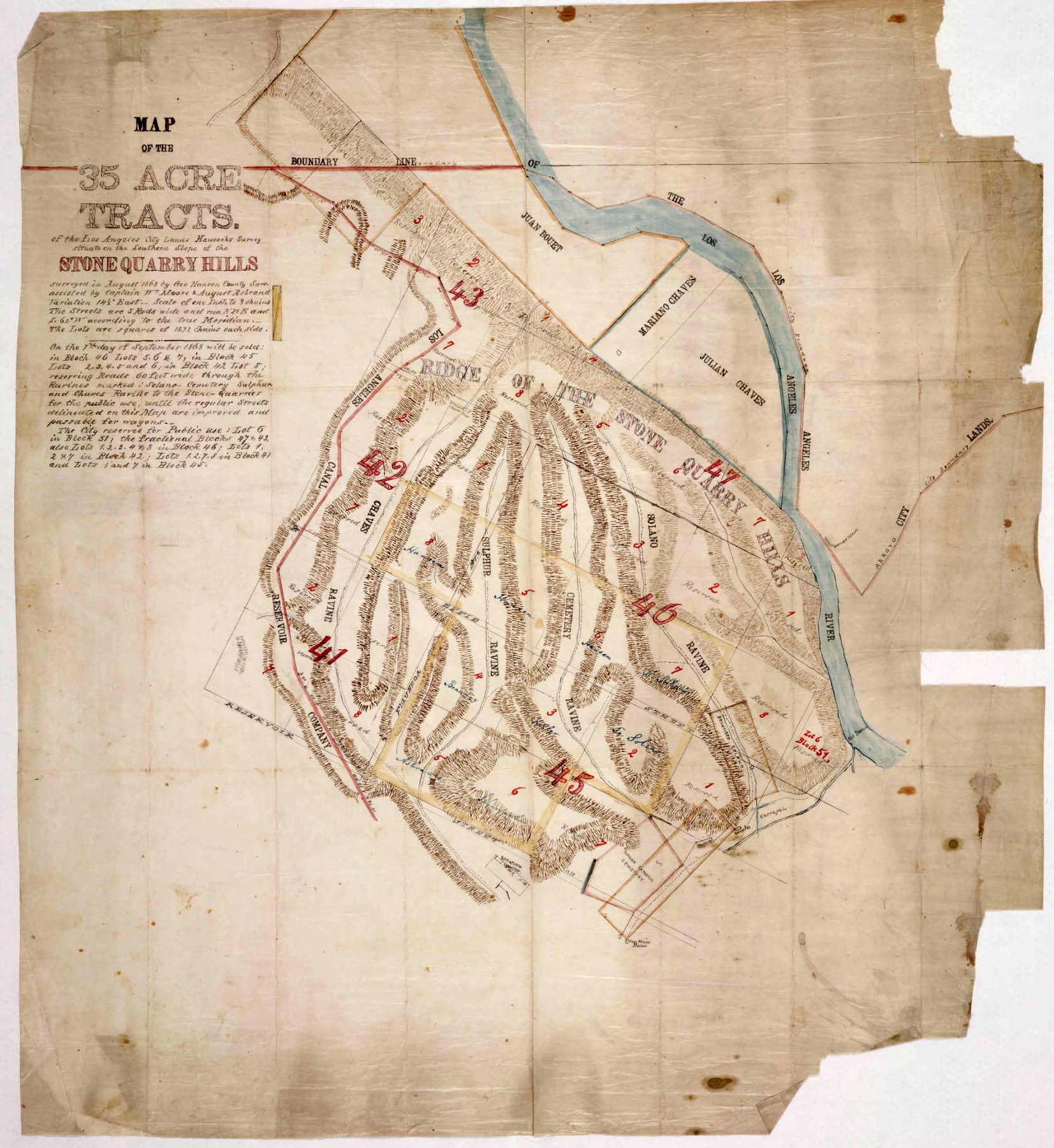
These are the tracts on the southern slope of the Stone Quarry Hills in the August 1868 George Hansen map, based on Hancock’s earlier survey.[34] The red line that is “Boundary Line” was the boundary of the municipal lands of Los Angeles in 1868. Anything to the north of that line was the Feliz Rancho land. Bouet’s parcel trespassed. The Ivanhoe map void in that area suggests the trespass had ripened through adverse possession to acknowledged ownership.
That void in the Ivanhoe map provides another clue to the location of El Portezuelo. That is, there is a bulge in the river in the 1868 map. “Puerta Suela” led from the bulge. That bulge is Frogtown.
Even though the river was channelized in the 1930s, the U.S. Army Corps of Engineers did not redirect the river through Frogtown to make a straight line. Around 1900, it was Gopher Flats, where railroad workers lived. Later it was “Little River Valley.” By the 1930s, that area was filled with houses, a school and industries, and the name was Frogtown, although some residents now believe the frogs may have been Western Toads.[35]
The bulge in the river means the distances measured with chains in the 1868 map were imprecise.
The Stone Quarry Hills map does not show a road directly upriver from the toma (The faint dotted line towards the bottom of the map), and the toma was a little upriver from today’s Broadway Bridge; that is, when the map was drawn, no route existed going up along the river from the plaza area downtown into the Feliz Rancho.
Diary entries of Juan Bautista de Anza and Father Pedro Font in February 1776
In 1776, Juan Bautista de Anza Bezerra Nieto led a group of colonists through Los Angeles. Seventeen families, 17 soldiers, 2 members of Anza’s personal company, Father Font — diarist for the expedition — and many horses and mules traveled from the San Gabriel mission in late February to a campsite the Spanish explorers called El Portezuelo.
The 1775-1776 Anza expedition totaled two hundred thirty-five people plus eight born on the way[36]. The wife of Vicente Feliz died in childbirth. Livestock consisted of 165 mules, 340 horses and three hundred twenty head of cattle.
The winter of 1776-1777 had been one of the driest the Spaniards had experienced.[37]
On January 1, 1776, Anza found the river near Riverside to be “almost un-fordable for the people, not so much because of its depth, as for the rapidity of its current, which upsets most of the saddle animals.”[38] Yet, less than two months later, neither he nor Father Font commented on the Los Angeles River crossing.
According to Bancroft, Anza’s 1775-1776 expedition left Mexico with 235 people, not including 8 infants born on route. They had 165 mules, 340 horses and 320 heads of cattle.[39] One woman died in childbirth – the wife of Vicente Feliz.
Assuming some of the horses and some of the mules remained with Moraga, the number of San Francisco colonists, priests, servants and Indian guides with Anza were large. Anza set out on the “regular road,” which suggests the expedition left the mission following the road the Portola expedition pioneered in 1769 and crossed the Los Angeles River at the same point as Portola had crossed – the area now spanned by the Broadway Bridge. The river on August 3, 1769 had been fourteen yards wide at the crossing point. It was probably wider after a sustained period of rain in January and early February 1776.
Anza’s wrote on February 21, 1776:
“At half past eleven, when everything was ready for the march, I set forth with seventeen of the soldiers and the same number of the families destined to remain in this California, besides six of my company. Four of these last are remaining here to await Lieutenant Moraga, as has been said, also to escort the cattle belonging to the colonists. I set out on the regular road to Monte Rey, which we followed for a little more than a league to the southwest. Continuing for another league to the west-southwest, we crossed the Porciuncula River.[40] After this we made three more leagues, traveling until five o’clock in the afternoon, having marched five and a half hours, when we halted at El Portezuelo, where the night was passed. Notwithstanding that for a number of days past it has not rained very hard, the road has been so heavy that many of the mules which carried the loads fell down.”[41]
Alan K. Brown translated and edited the journal of Pedro Font, O.F.M.[42] Brown depended in part on the discovery by Spanish Franciscan historian Luis Soto Perez, who published a manuscript that was the actual draft journal that Font wrote during the course of his travels.[43]
Father Font wrote:
(February) 21, Wednesday, I did the blessing of ashes; I said Mass, and during it four words to the people who were remaining and to the rest of them who were going (who wept a bit since they regretted this separation), by using the gospel of the day to reaffirm what I had been saying to them in the talks I gave them. That is, that they had come in order to suffer and give an example of Christianity to the gentiles, etc., the whole of it amounting to exhorting both groups to repent for their faults and patience in hardship, etc., etc. We went out from Mission San Gabriel at a half past eleven in the morning and halted at a half past four in the afternoon at the spot called El Portezuelo having traveled for five leagues following a west-northwestward course with some veering to one side and the other. At two leagues we crossed the Porciuncula River, which carries a good amount of water and runs toward the San Pedro bight, and spreads out and loses itself upon the plains shortly before reaching the sea. The land was very green and flowery and the route had a few hills and a great deal of miry grounds created by the rains. This is why the pack train fell far in the rear.[44] At the stopping place there is year-round water, although little of it, and sufficient firewood. As one goes along, far off on the left hand, upon the sea, lies the hill range forming the San Pedro bight, and on the right rises the snowy range, with another steep, steep range lying in front of it.” [45]
The “snowy range” was the range of the San Gabriel Mountains. Official records of snowfall in Los Angeles began in 1877. Measurable snow fell in downtown Los Angeles in 1882, 1932 and 1949. The last time snow fell somewhere in the Los Angeles basin was in 1962. Los Angeles is roughly five degrees Fahrenheit warmer than it was a century ago.[46] Snow, however, sometimes still covers the tops of the San Gabriel Mountains. The smaller range was the Verdugo Mountains.
A “bight” is a curve or recess in a coastline, river or other geographical feature. It typically indicates a large, open bay. Juan Rodriguez Cabrillo discovered the bay that would be known as San Pedro in 1542. Font did not see the bight itself from wherever it was that he stood; rather, he saw a hill range that formed the bight “far off on the left hand, upon the sea.” He was probably looking at the Palos Verdes peninsula.
This description suggests Father Font could not have seen the Verdugo Mountains and the San Gabriel Mountain range from the Cahuenga Pass.[47] He could have seen the Palos Verdes peninsula.
Neither Font nor Anza further described the location of El Portezuelo.
On the return trip through the area on April 28 and April 29, Font describes different distances and possibly a different route. On April 28, 1776, at 7 a.m., the returning members of the expedition set out from El Agua Escondido.[48] They traveled “northeastward through hills for about a league. We then went down the grade and, by it and the hollow, traveled about a league east-northeastward and came out upon the Santa Isabel plain[49] and traveled eastward over it for some eight long leagues. Then we went into the gap[50] and continued through hills, course east-southward with some veering east and east-northeastward, as far as the Porciuncula River, and halted there at a bit before five o’clock in the afternoon, having traveled some fourteen leagues. The dryness continued hereabout and as far as the snowy range that had almost no snow because there had not been any rain and there was heat here.”[51]
April 29, Monday. “We set out from the Porciuncula River at a quarter past six in the morning and at eight o’clock reached Mission San Gabriel, having traveled two leagues on a course east-southeastward for a very little way, eastward a little and the remainder east-northeastward for a bit over one league.”[52]
Crystal Springs (Lago del Portezuelo) as a possible Anza campsite
The “stopping place” had “year-round water, although little of it.”
The river itself had year-round water, although perhaps it was not potable at the “stopping place.”[53]
The 1843 Feliz Rancho diseño showed a little lake with a squiggly line leading to the river. The Laguna del Portezuelo[54] may have been one of the natural springs that emerged from the subterranean flow of the Los Angeles River. If the lake (today’s Crystal Springs picnic area) had been El Portezuelo, the Anza expedition would have found a lot of water, so the expedition probably did not stop at Crystal Springs.
Muangna as possibly El Portezuelo
The 1868 map drawn by George Hansen, “Rancho de los Felis: division line, Coronel and Lick Properties[55] showed an image of a tree labeled “oak” and, in slanting script adjacent to the oak are the words “Puerta Suela.”
The “Old Ranch-House” was designated by a square; that was the only ranch house in the 1843 (or 1853) map. The New Ranch House is to the north, designated by a little box. The new ranch house exists today. It is the ranger station at 4370 Crystal Springs Road. It was and is located near Crystal Springs, now a Griffith Park picnic area.
The Hansen map showed meandering straight lines with dots. Those lines may indicate roads that existed in 1868.
The big box that occupied the Hansen map designated the Los Angeles City boundary lines in that area.
Above the boundary City’s boundary line is the “Part of Lick.” This was the portion of land in the Feliz Rancho acquired by Antonio Coronel[56] and sold to James Lick. The dividing line of “the parts of Coronell (sic) and Lick” was to the north of the Part of Lick.” The Portezuelo (“Puerta Suela”) was in the Lick portion on the eastern side.
Near the Hyperion Bridge
In the 1950s, there was a double-screened drive-in theater next to the Hyperion Bridge. Now it’s very difficult to see how broad the land area once was because of the I-5 and its various ramps. That former drive-in area was big enough to have provided pasture for all of the animals in the Anza expedition.

Comparing the distances in the 1868 Hansen survey with Google translated distances of the same area, the landmark oak was at about the location of today’s Hyperion Bridge.[57] If the distances are correct, that landmark tree was on the Silver Lake side of Waverly Heights because the hill was not to be excavated until about 1921.
Below is a photograph from the USC Digital Library. The bridge was not yet complete in this photograph. The Riverside Lumber Yard that shows in the photo was probably on Riverside Drive. Waverly Heights was one continuous hill before the bridge was completed.[58] The road that appears partly finished below the new bridge was Glendale Boulevard. The big house at the top was at 3021 Waverly Drive, built in 1921. It’s still there.
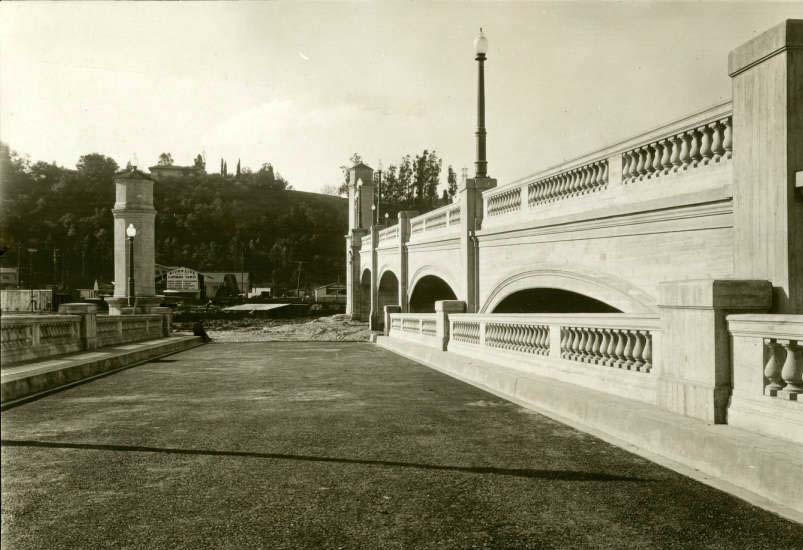
Hyperion Avenue Bridge, Glendale,1920.
This area was not a gateway to the river in 1776. The City did not excavate that hill creating a gateway to the river until after 1920.
Riverside Drive and Los Feliz area (“Muangna”)
The unidentified man sat under the boughs of a tree that took hundreds of years to grow. A tree that size was probably there when the Tongva village of Muangna was located at the time of the 1776 Anza expedition. It was likely a landmark that could be seen from a distance.
Muangna was probably located in the area between today’s Riverside Drive and today’s Los Feliz Boulevard.[59] The map that faces page 1 of Bernice Eastman Johnston’s California’s Gabrielino Indians shows Muangna on the flat area, the area that might be what Anza meant by El Portezuelo and the area that could be where the man sat under tree boughs.
The Indians had had over 10,000 years to find the best places so there may have been a creek or a spring in the Muangna area (From the Los Angeles River near the swimming pool east along Los Feliz Boulevard to Fern Dale, which had a spring.)
Two other places could be Anza’s El Portezuelo campsite.
The Sacatela Creek corridor from the Hyperion Bridge
A dale runs from about today’s Hyperion Bridge between two hills — the Los Feliz hills and the Moreno Highlands hill. Micheltorena street parts the Moreno Highlands hill along the top. At one time, that dale ended at the base of Waverly Heights.
Griffith Park Boulevard and Hyperion Boulevard run through this area intersecting near the Gelson’s — previously the location of the Walt Disney Studio.[60] John Marshall High School (1931) is in the flat area between the two hills. On the western end is Sunset Boulevard (1904) and just before Sunset is Thomas Starr King Middle School (1926). Griffith Park Boulevard had been the route of the Ostrich Farm train so Hyperion Boulevard probably ran along-side it.
There was – and apparently still is, although the water now runs through pipes underground — a spring where Monon and Tracy Street meet just west of John Marshall High School (Marshall is between Tracy and Griffith Park Boulevard.). This creek fed the Sacatela Creek, which flowed south.
A 1916 City engineering project diverted into subsurface storm drains. The creek bed was then either paved over (Monon Street and Myra Street) or built over (Thomas Starr King Middle School).[61] The address of Thomas Starr King Middle School is 4201 Fountain Avenue. A mill once stood on the creek at or near today’s Child’s Court off Griffith Park Boulevard. The creek flowed down to Hyperion or to Griffith Park Boulevard past King Middle School and it’s probably the creek that ran under the Shakespeare Bridge: Sacatela Creek.
Sacatela Creek flowed south to Arroyo de los Reyes, today’s Echo Park Lake.[62] Water from the perennial Arroyo de los Reyes stream flowed along the side of today’s Bunker Hill (when it was higher than it is today) into the downtown Los Angeles Street, at the place marked for Olive Street on Ord’s La Plan de la Ciudad de Los Angeles.

Circa 1887 view of Second Street Park, a little lake just south of Echo Park. The park was located in the Arroyo de los Reyes ravine. Courtesy of the Title Insurance and Trust/C.C. Pierce Photography Collection, USC libraries.
The fourth possibility for El Portezuelo is Silver Lake.
At one time a stream ran through what is today Silver Lake — formerly a reservoir, and before that a meadow.
Catherine Mulholland wrote in William Mulholland and the Rise of Los Angeles[63] that William Mulholland lived at a work camp in the Ivanhoe area when he worked on the Crystal Springs percolation project in 1890. Her great-grandfather owned a farm in the Kenilworth tract, which adjoined the Ivanhoe Tract.[64]
According to an interview with William Mulholland on May 8, 1927, the “Moreno Highlands” was originally part of the Pueblo Land Grant of 1781, but Mulholland was wrong. The Moreno Highlands were on the lands occupied by the Los Feliz Rancho. The meadow, too, was mostly on the Los Feliz Rancho.
The Spanish Colonial settlers and their Mexican era successors had vague boundaries. They used natural monuments to mark boundary lines: an oak tree, a stone that looked like an eagle, a stone that looked like a bee hive, a cluster of cactus, the river, a ravine. The American-era surveyors drained actual metal chains across the land to measure between those monuments and labeled the natural monuments on their surveys.
“The romance of Moreno Highlands dates back to the old Pueblo land grant. I know every inch of this beautiful property. Forty years ago, I lived within a half-mile of what is now Silver Lake.[65] We used to walk to the top of the surrounding hills, which were considered the finest viewpoints in Los Angeles.
“Somewhere along in the ‘90’s Mills & Wicks (sic, Wickes – he also purchased Santa Catalina Island) real estate men, purchased this property from Lyons (Cyrus Lyon) with the intention of subdividing it. They named this property Ivanhoe Hills.[66] They named many of the streets after famous characters of Scotland, for example, Kenilworth Avenue, which is still used.”[67]
“In 1886, G. J. Griffith obtained this acreage from Mills and Wicks. During the next few years, Griffith sold parts of this land. Five years ago (1921) Mrs. Antonio Moreno[68] purchased Mr. Griffith’s remaining land and from other sources obtained the balance of the acreage.”
Silver Lake, 1906. This is Courtesy of the Huntington Digital Library.
The bulge outward of the river on the 1868 map of the Feliz Rancho looks like the bulge had been exactly opposite the angle of “Puerta Suela.”
The U.S. Corps of Army Engineers largely straightened out the more nuanced river curves in the 1930s but that bulge remained, likely because by the 1930s people had built houses and businesses.
That bulge is the bulge outward that began on the Bouet-tract side of today’s Fletcher Drive. Frogtown was mostly within the municipal boundary.
The location on early maps of “Puerta Suela” on the Feliz Rancho at about the bulge, about at Rattlesnake Park, supports the possibility that Silver Lake is El Portezuelo.
Other theories of where El Portezuelo was
H.E. Bolton
Bolton’s footnote 2 on page 105 of volume III of his Anza’s California Expeditions states, “The route was evidently along the line of the Southern Pacific Railroad through Alhambra to Los Angeles River, thence northwest up the river through the Portezuelo. Camp was at the turn of the mountains west of Glendale.”
E. Bolton’s map of the routes Anza took in his two expeditions was “compiled from original data and personal explorations.” The only original data he could have used for the map were the explorer diaries, including the diaries of those accompanying the expeditions into New California.
The diary entries do not explain the route Anza took. Bolton’s source for the 1776 Anza route was therefore based on his personal explorations.
Bolton explored Anza’s route between Riverside and San Francisco by train and automobile many times since 1909.[69] In 1909, the train route from Riverside went to the Southern Pacific Railway rail yard and — from the River Station — along the western side of the river north. In 1900, there was still no road that went directly north from the place the expedition crossed.[70]
There was a road through the back of Frogtown at the base of the Elysian Park hills by about the 1880s or 1890s that was probably part of Riverside Drive. Eucalyptus trees framed the view in the photograph below. The first blue gums arrived in Southern California when William Wolfskill planted five specimens outside his house in 1865. The trees turned into a “regional face” when Abbott Kinney – Indian researcher with Helen Hunt Jackson, developer of Venice California, and tobacco heir – used his permission as state forester from 1886 to 1888 to promote the planting of eucalyptus trees and to distribute free seeds.[71]
Courtesy of Los Angeles Public Library.
There was, however, only the Southern Pacific tracks below Figueroa, which American-era engineers dug through Elysian Park, and SP dug into Elysian Park to make room for the tracks; the hills came right up to the river before Southern Pacific Railway arrived in Los Angeles in 1876, occupying today’s Los Angeles State Historic Park, popularly known as “the Cornfield.”
Bolton’s map facing page 152, An Outpost of Empire,[72] indicated Anza stayed at the San Gabriel Mission then traveled north to “Portezuelo” along the river, which was not possible in 1776.
On this map, Bolton located “Portezuelo” at the edge of land at the bottom of the tall hill where the river bends and turns south – between the Santa Monica Mountains and the Verdugo Mountains, which suggests Bolton thought Portezuelo was the same thing as the Narrows – except that on page 359, Bolton wrote that El Portezuelo was near Glendale, which was and is on the east side of the river.
W.W. Robinson’s theory
W.W. Robinson, on the other hand, identified El Portezuelo as the site of modern Burbank.[73] This was Mariano Verdugo’s land grant, which was on the eastern side of the river and was called the Rancho San Rafael; however, Rancho Portezuelo was absorbed into the Rancho San Rafael, and he sold it to Mission San Fernando Rey in 1810.
Rancho Portezuelo was a 1795 grant. M. M. Livingston, in “The Earliest Spanish Land Grants in California,” states – without a footnote – that Rancho Portezuelo was in today’s San Fernando Valley.[74]
In 1871 Rancho Portezuelo was part of the San Rafael Rancho, also known as the Verdugo ranch. The San Rafael Rancho included Burbank, Glendale and La Canada cities. During that time Rancho Portezuelo was in the pass between the Verdugo Rancho and the Rancho Feliz, although separated by the river. (The Feliz Rancho also included an edge of today’s Burbank, and that area is in the San Fernando Valley.)
Robert G. Cowan and Jackson Mayers[75]
Robert G. Cowan, in Ranchos of California, sited “portezuela” (sic) at Universal City.[76] Jackson Mayers[77]) also places Anza’s campground on the Cahuenga Pass. The Friends of the River guide to the Los Angeles River also places El Portezuelo as the Cahuenga Pass, “with the campsite along the river near present-day Universal Studios.”[78]
Mike Eberts
In a note under the reproduction of a painting of Juan Bautista de Anza in full Spanish explorer regalia,[79] Eberts stated, “The Anza party traveled north along the Los Angeles River from present-day Elysian Park. They camped at a place called El Portezuelo, which is probably the site of today’s John Ferraro Soccer fields at the northwest corner of the park.”[80]
Conclusion
The 1776 Anza campsite of El Portezuelo would, about 20 years later, be included in the Feliz land grant. Vicente Feliz had been a soldier in the 1776 expedition. He knew where El Portezuelo had been.
Although none of the possibilities for the location of El Portezuelo can be ruled out, Bolton’s location is unlikely because it depended on Anza traveling up a road that did not exist in 1776 along the river. The Cahuenga Pass route is unlikely because it was a longer route, and Anza and all those mules only traveled about 6 hours, including time spent extricating mules from mud.
Crystal Springs was an unlikely place because the area around the spring would have been spongy; it was not a gateway to the river but was on the river; and there was plenty of water so it doesn’t fit with the description of a place with water, but little of it.
Silver Lake is a candidate because of its location near the bulge in the river, and because it was a meadow with a creek. The route from it could have led from Glendale Boulevard to Fletcher Drive to Rattlesnake Park, and there could have been a road along the river from about Fletcher Drive up through the Narrows.
Although, there the surveyors and map makers did not show a river road – although one of the lines might have been a road – there may have been one.
The corridor between King Middle School and Marshall High School also is a strong possibility because of Sacatela Creek and because the railroad tracks for the Ostrich Farm train suggest a road once up along where the spring was (or is) towards Griffith Park. Anza could have followed that road up to about where the Merry-Go-Round is through the winding road in the back of Griffith Park down through today’s Forest Lawn extension to Ventura Boulevard.
Similarly, Muangna, where the man sat under the boughs of a tree, is a possibility if there was a creek or spring there.
Anza traveled five and a half hours from the site of the new mission, commencing the day’s journey at 11:30 a.m. After crossing the river at about today’s Broadway Bridge, the expedition traveled about another three leagues – 10.8 miles.
It was about 1.8 miles to the beginning of El Camino Viejo near Yang-Na from the fording location. About 2.1 miles along El Camino Viejo to the place where the road branched and went towards Echo Park Lake.
To Silver Lake from the place where El Camino Viejo branched and turned through the hills to the Silver Lake meadow is – using today’s roads – about 3 miles.
From the bottom of Echo Park lake to Tracy Street and Monon Street where the natural spring was, using today’s roads – and not going over steep hills – is 3.4 miles.
From the bottom of Echo Park lake to the Kool-Aid fountain is 4.4 miles from the bottom of Echo Park Lake using today’s roads.
The location of the “new” Feliz rancho house on Crystal Springs Drive is 0.8 miles from the Kool-Aid fountain: 9.1 miles from the place where Anza had crossed the river,
Bolton’s location on North Zoo Drive near the bend in the river is 2.8 miles from Crystal Springs: meaning a possible journey of 11.9 miles,
The best fit of distances and description to the 1776 El Portezuelo campsite — is Muangna, where a man would sit under the branches of an oak tree about a hundred and twenty years later.
Notes
[1] Mike Eberts, Griffith Park, A Centennial History, (The Historical Society of Southern California, Los Angeles, California 1996), at page 10. The Ostrich Farm existed from 1883 to 1889. Eberts, pages 22-23.
[2] Ervin King, in “Boys’ Thrills in Los Angeles of the ‘70s and ‘80s,”[2] The Quarterly: Historical Society of Southern California, Vol. 30, No. 4. (December 1948), pp. 302-316,
[3] Mike Eberts, Id, page 79.
[4] Eberts, Id., page 48.
[5] Eberts, at page 48.
[6] Elisabeth Mathieu Spriggs, The History of the Domestic Water Supply of Los Angeles, unpublished thesis, Department of History, USC, January 1, 1931, page 68. The tree is the photo of Man Sitting Under Tree Boughs is an oak. Mulholland was an engineer not a botanist – maybe he thought all trees were sycamore trees. The man in the photograph looks like Mulholland but then probably every white man wore clothes like that and had a mustache in the 1890s. Even store mannequins had mustaches into the 1950s.
[7] In 1910, probably about 20 years after the Man Sitting Under Tree Boughs was photographed, a wooden bridge spanned the river as the main entrance to today’s Atwater Village, previously called simply Atwater. The wooden bridge collapsed into the water after a flood in 1927. The support for the Los Angeles-Glendale trolley along the side of the bridge may have been constructed in 1904, when the train route was extended over the river. There are concrete supports for the tracks that used to run across the river next to today’s Hyperion Bridge, and the pediments for the viaduct that supported the viaduct over Fletcher Drive remain along Ivanhoe Hill above Fletcher Drive. Crossing today’s bridge into Atwater and close to the supports for the train is a mural of a Red Car with the name of the car on the train as “90039,” the zip code for that area, printed on the car. The bridge entrance on the Atwater side featured in the partly animated film 1988 film Who Framed Roger Rabbit, a fictional story to explain the demise of the Red Car.
[8] There was no Los Feliz Boulevard until the turn of the 20th century and the predecessor to Riverside Drive did not exist until sometime possibly in the 1880s or a decade earlier.
[9] In 1773, Father Junipero Serra suggested that “respectable Spanish families” should be settled in California. “He was talking about soldiers’ families who would settle about the presidial posts…” Edwin A. Beilharz, Felipe de Neve First Governor of California (California Historical Society, San Francisco 1971), p. 97.
[10] The first Spanish land expedition — the 1769 Gaspar de Portola expedition — went through today’s downtown Los Angeles to Santa Monica, doubled back and went over the Sepulveda Pass, and that expedition returned by the Cahuenga Pass.
[11] Josiah D. Whitney, Names and Places Studies in Geographical and Topographical Nomenclature (Cambridge University Press 1888), page 141.
[12] http://dpw.lacounty.gov/wrd/Runoff/design.cfm?facinit=F252-R. (Retrieved 6/8/2018).
[13] Blake Gumprecht, The Los Angeles River: Its Life, Death, and Possible Rebirth, (John Hopkins paperback edition 2001, Baltimore Maryland), page 14
[14] Id, at page 15.
[15] See, Phyl Diri, “Where the Fern Brake and the Willow Find a Home, L.A’s’ Elysian Park,” California History, The Magazine of the California Historical Society, Fall 1983, pages 162 – 169.
[16] For a time during the early years of the American era, “Toma Street” – the road that led from the first Spanish village to the Indian village of Yang-Na – was called “San Fernando Street.” This name suggests that very early route from the San Gabriel Mission swung through today’s downtown Los Angeles to the Cahuenga Pass to the San Fernando Mission along the middle branch of El Camino Viejo.
[17] Eberts limits the Tongva’s venue to today’s Hollywood. He does not explain why.
[18] Bernice Eastman Johnston, California’s Gabrielino Indians (Southwest Museum, Los Angeles, California 1962), p. 9. Kawengna meant “Place of the Mountain.” Id, p. 10. So far, I have been unable to find out who Bernice Eastman Johnston was – except that she was the wife of Phillip Johnston who grew up on a Navajo reservation and sponsored Navajo code talking during World War II — but her work on the Tongva people is frequently cited, and the Southwest Museum sponsored her work. Hugo Reid was an immigrant originally from Scotland that married a Tongva woman and acquired as a result – from the Mission San Gabriel padres by later confirmed by Pio Pico — an enormous grant of land, now partly occupied by the Los Angeles Arboretum and Botanical Garden and San Marino. Reid wrote a series of letters to the Los Angeles Star/Estrella on the Tongva people shortly before his death in 1852.
[19] Johnston, page 127.
[20] Diseño in Spanish means, “design.”
[21] “Diseño del Rancho Los Felis.” Traced by Lauren Upson in 1865. http://hdl.huntington.org/cdm/singleitem/collection/p15150coll4/id/11388/rec/1. (Retrieved 6/28/2018) The text states it is part of ribbon bound dossier Poseción del Rancho de los Felis” showing Laguna del Potrero (sic, it says “Laguna del Polrero”), sierra, trees, Borders (linderos). arrastradero ,rio del pueblo, del aguaje, de la breyata.” Neither “Potrero” nor “Polrero” are Spanish words. Breyata is also neither a Spanish nor an English word. Rio del pueblo is obvious: the pueblo’s river. Arrastradero means “”trailer” today but it also meant a road by which logs are dragged or a spot whence dead bulls are taken off.
[22] The scale looks like 2” represents a milla. A Spanish milla was 2.597 English miles. The river to what appears to be the Cahuenga Pass on this design is 8.1 miles. The distance from the river to the Cahuenga Pass today is only 4.1 miles. The distance on the design from the turning in the river to what is probably going to one day be the Crystal Springs picnic area is 5.4. miles. The scale appears to make no sense. Although the design is written in Spanish, with Spanish measurements, before the American era, unless neighbors disputed the boundaries, no one made surveys. This map may have been drawn to show title in litigation under the United States Land Act of 1850. Consequently, the original may have been drawn in 1853.
[23] Governor Pedro Fages was Governor from 1782-1791. Diego de Borica was Governor in 1795. Although many sources indicate Fages granted the rancho to Feliz, that was not possible. Diego de Borica was the grantor.
[24] This is from the Library of Congress. https://www.loc.gov/resource/g4364l.ct001800/, (Retrieved 6/21/2018)
[25] Robert Fogelson, Fragmented Metropolis: Los Angeles, 1850-1930. (Originally published in 1967. Paperback edition, University of California Press 1993).
[26] “Plat of Rancho Los Feliz, line from Nopalero to Portezuelo.” http://hdl.huntington.org/cdm/singleitem/collection/p15150coll4/id/12370/rec/1. (Retrieved 6/17/2018) . The author of the map was Lothar Seebold. Seebold was one of the copyists of the 1849 E.O.C. Ord La Plan de la Ciudad de Los Angeles.
[27] The cataloger correctly interpreted the description to Portezuelo in the description below this Huntington Library map.
[28] “Map of Ivanhoe,” Silver Lake area. http://hdl.huntington.org/cdm/singleitem/collection/p15150coll4/id/5031/rec/5. (Retrieved 6/17/2018).
[29] “Map of Ivanhoe, Los Angeles County, California.” http://hdl.huntington.org/cdm/singleitem/collection/p15150coll4/id/5031/rec/5.
[30] Glenn S. Dumke, The Boom of the Eighties in Southern California (Huntington Library, San Marino, California (first published in 1944. The information about Ivanhoe is from the sixth printing in 1991).
[31] Dumke, Id., page 188.
[32] Waverly, Angus, Avenal, Scotland, Armstrong, Teviot is a street but at another location than the one proposed, Kenilworth, Melrose is today’s Hyperion Boulevard but there is a Melrose on the other side of Sunset (not part of the plan), Franklin, St. George, Tracy Street, Scott Street was moved to the Echo Park district as was Morton, and Rowena.[32] The C.W.C. Reservoir is now a closed park, but it is the same size now as it was then (This reservoir is above Rowena). Melrose on the map transitioned seamlessly to Clyde Street. Both are today Hyperion and both lead to the Hyperion Bridge. Redesdale exists but not at the location on the map of Ivanhoe.
[33] Raymond Chandler called the lake “Gray Lake” in the collection of stories Trouble is My Business in 1934. During the 1930s, Chandler briefly lived in a duplex on at 1637 Redesdale.(Jessica Gelt, “Dive Into Cool Silver Lake,” Los Angeles Times, 11/12/2006. Gelt repeated as truth, however, the myth that Hugo Reid named the area Ivanhoe. Reid died in 1852, 34 years before real estate developers named Ivanhoe). “Gray Lake,” Chandler wrote, is an artificial reservoir in a cut between two groups of hills, on the east fringe of San Angelo. Narrow but expensively paved streets wind around in the hills, describing elaborate curves along their flanks for the benefit of a few cheap and scattered bungalows.” (The streets were never elaborately paved, and there were a lot of houses along those elaborate curves.)
[34] “Map of the 35 Acre Tracts of the Los Angeles City Lands.” http://hdl.huntington.org/cdm/singleitem/collection/p15150coll4/id/11777/rec/1. (Retrieved 6/28/2018).
[35] I think the neighborhood was named after frogs. I grew up until I was 7 – until 1953 — near the eastern bank of the river opposite Frogtown. I, like other neighborhood children, stood in the river and caught black tadpoles in glass jars, which, of course, our parents threw out. Hundreds of frogs lived in the basement of our house. Western Toads are tiny. The basement frogs looked enormous.
[36] Hubert H. Bancroft, History of California (San Francisco: The History Co, publishers, 1886) Vol. I, p. 258. Fr. Francisco Palou, Historical Memoirs of New California, edited by H. H. Bolton (Berkeley: University of California Press, 1926), Vol I, p. 83. The author states there were two hundred thirty “all of whom were to remain in the new settlements that were to be founded.”
[37] Beilharz, op cit., page 101.
[38] Citation from Engineer Lynch’s study of rainfall since 1769 in Los Angeles (Op. Cit.) Lynch cited, among many works, Bolton’s Anza’s California Expeditions. When I was three years old, it snowed in Los Angeles. In 1982, I participated in a hike through Elysian Park led by an 83-year old docent. He said that, even in his childhood, it rained more often, and the weather was cooler.
[39] Bancroft, History of California, volume 1, 1542-1800 (Reissued 1886 by The History Company, San Francisco). Anza’s diary indicated seventeen soldiers and their families and two of Anza’s company left the Mission San Gabriel. Moraga stayed behind with four members of Anza’s company and later brought the cattle.
[40] This description fits with a starting location at the second San Gabriel Mission located where it is today. The first mission was located near the intersection of San Gabriel Boulevard and Lincoln Avenue. Anza’s description does not correspond to the route from the old mission site. The California Missions Foundation website shows that the second mission (today’s structure) dates from 1775 to “improve conditions for planting and cultivating.” http://californiamissionsfoundation.org/mission-san-gabriel/. (Retrieved 6/12/2018)
[41] Herbert E. Bolton, Anza’s California Expeditions, Volume III (University of California Press, 1930)., page 107, “Anza’s Diary.”
[42] Alan K. Brown, translator and editor, With Anza to California, 1775-1776: The Journal of Pedro Font, O.F.M. (The Arthur H. Clark Company, an imprint of the University of Oklahoma Press, Norman, Oklahoma 2011).
[43] Id, page 9
[44] Mule hooves are smaller than horse hooves.
[45] Brown, page 215.
[46] Nathan Masters, “Why Doesn’t It Snow in L.A. Anymore?” KCET. Lost L.A., December 9, 2016. https://www.kcet.org/shows/lost-la/why-hasnt-it-snowed-in-los-angeles-since-1962. (Retrieved 6/10, 2018).
[47] Proponents of the position El Portezuelo was in the Cahuenga Pass argue that Font did not realize that the Santa Monica Range was one continuous range and that he saw part of the range he passed through and thought it was a separate mountain.
[48] The National Park Service website indicates the exact location of Agua Escondido is not known. https://www.nps.gov/juba/learn/historyculture/california-anza-trail-sites.htm. (Retrieved 6/3/2018). The National Park Service website locates El Portezuelo within Griffith Park. It could have been a destroyed spring in the Deer Springs tract off Lost Hills Road in Calabasas. http://www.cityofcalabasas.com/historic/june2012.html. (Retrieved 6/3/2018)
[49] See Brown, page 216. Shortly after leaving “the stopping place,” most likely El Portezuelo, the expedition entered “a very spacious valley called Santa Isabel, at the middle of which and at a little over three leagues is the placed called Los Nogales, which is a small spring of water like a little lake, issuing in the midst of the plain, near which there are small walnut trees. And at about seven leagues we came to the foot of the mountains, which together with the range which we crossed through the gap yesterday, and today have been leaving upon our left, and with the other range running in front of the snowy range of mountains, which we had been having on our right, make this valley and it ends here.” Santa Isabel Valley seems to be today’s San Fernando Valley –Brown comments that name was probably an error, but the San Fernando Mission was not built and the valley absorbed until 1797. The 1769 expedition had named the valley Santa Catalina.
[50] The gap was probably the Cahuenga Pass.
[51] Brown, page 366.
[52] Brown, pages 366-367.
[53] “Owing to storms in the rainy season, which made the water in the surface flow, roily and unfit for use…” Edna Agnes Cocks, “The Biological Aspect of the Los Angeles City Water,” unpublished thesis presented to the Department of Biology University of Southern California June 2, 1916. Page 7.
[54] The map copyist wrote the name of the lake fairly illegibly. It could be El Portero or El Porrero, neither of which means anything in Spanish. The lake was probably originally Laguna del Portezuelo. The lake was gone by the time of the 1868 map and was instead a marshy area, today’s rather spongy Crystal Springs picnic area.
[55] “Rancho de los Felis: division-line, Coronel and Lick properties,” http://hdl.huntington.org/cdm/singleitem/collection/p15150coll4/id/11395/rec/7. (Retrieved 6/17/2018)
[56] Eberts states that Coronel was born in Spanish California. He was born in Mexico and arrived in Los Angeles when he was 17 with the Hijar-Padres Colony in 1834. The colony was formed to acquire land the missions owned after secularization. Eberts also states that Coronel’s wife was a Yankee. Mary “Mariana” Burton Williamson was born in San Antonio Texas. Her father was from Maine. Her mother was a Mexicano Tejano woman from Los Brazos River area. From a document located by J.M. Guinn, Coronel was the executor of the Feliz Rancho at the death of Antonio Feliz.
[57] Mark Blaszyczyk did the distance calculations on 6/19/2018. Mark is a Public Works Construction Inspector at the City of San Jose. If the Feliz ranch house was moved, however, that algorithm wouldn’t work.
[58] http://digitallibrary.usc.edu/cdm/singleitem/collection/p15799coll65/id/26177/rec/19. (Retrieved 6/27/2018)
[59] See, Blake Gumprecht, The Los Angeles River, Its Life, Death and Possible Rebirth. Professor Gumprecht created a map from the Welts map in the Eastman book on California Indians, figure 1.6. page 30. Gumprecht placed Muangna on top of Waverly Heights — an unlikely location because, as he points out elsewhere, the Tongva lived near creeks and rivers. Besides, the source for the Gumprecht map was the Welts map that was in in the Johnston book (California’s Gabrielino Indians), and his source showed Muangna as approximately in the area of today’s Los Feliz Boulevard and today’s Riverside Drive. On the other hand, Eastman thought El Portezuelo meant “little door,” so maybe the Southwest Museum staff just made things up.
[60] Roy and Walt had an earlier studio in Los Angeles, a small building near Vermont. Before the brothers rented that building, they worked in the garage of their uncle’s nearby house.
[61] David Kimbrough, “Shakespeare Bridge and the Sacatela Creek,” Bridgehunter.com. http://bridgehunter.com/ca/los-angeles/53C0161/. (Retrieved 6/18/2018).
[62] LA Creek Freak, January 10, 2010. The creek flowed along the path that is now Glendale Boulevard to Second Street. https://lacreekfreak.wordpress.com/tag/arroyo-de-la-sacatela/. (Retrieved 6/18/2018.)
[63] Catherine Mulholland, William Mulholland and the Rise of Los Angeles (2000, Regents of the University of California).
[64] The unidentified man sitting under the tree boughs could be William Mulholland, about the time he met Catherine Mulholland’s grandmother, who was living in her father’s farm in the Kenilworth tract. Mulholland married Lillie Ferguson on July 3, 1890.
[65] If he lived in that shack in the 1880s at about the Kool-Aid Fountain, he lived 1.8 miles from the meadow, not within half a mile. After he worked at the Crystal Springs project he moved from the shack to the Buena Vista Reservoir in the Rock Quarry Hills (Built in about 1870) part of Elysian Park in after 1886. “
[66] The developers named it Ivanhoe not Ivanhoe Hills.
[67] The speculators named streets after characters in Sir Walter Scott novels, e.g., Kenilworth, Ivanhoe, Waverly and Rowena.
[68] Antonio Moreno was a silent screen star that made the transition into “talkies.” When he was an old man, he played “Carl Maia” in the 1954 film The Creature from the Black Lagoon, shot at the Los Angeles Arboretum and Botanical Garden. Antonio Moreno’s wife was Daisy Canfield (1884-1933) daughter and heir of oil pioneer Charles A. Canfield. Canfield developed the first oil fields in the city of Los Angeles near Second Street with Edward L. Doheny. The Antonio Moreno-Daisy Canfield mansion built in 1923 – “Paramour” –at the highest point of the Moreno Highlands on Micheltorena Street still stands, hidden behind tall walls. Micheltorena Street flows into Moreno Drive in front of 2300 Moreno Drive. It’s likely the street was “Micheltorena” after the Mexican-era governor of California that confirmed the Feliz Rancho land grant. Antonio Coronel, who was to acquire the Feliz Rancho land, knew Governor Micheltorena well. See, Frederico Alberto Sanchez, Antonio F. Coronel, A Californio and A Ranchero: His Life and Times in Mexican Alta California, 1834-1850, Vol. I, unpublished dissertation presented to the Faculty of the Graduate School University of Southern California (October 1983), pages 191-215. http://micheltorena.org/about-us/history/. (Retrieved 6/22/2018). A L.C. Wright 1885 Survey shows Micheltorena Street near Effie and Reservoir. http://hdl.huntington.org/cdm/singleitem/collection/p15150coll4/id/12076/rec/2. (Retrieved 6/22/2018). Reservoir does not now reach Micheltorena Street. Blue lines on the survey indicate creeks, including one that appears to be at the base of one of the hills above today’s Silver Lake. The proposed canal – “Porciunguala”– is on another 1885 survey, and on that, it is the Porciuncula (Spanish name for the LA River) Canal. http://hdl.huntington.org/cdm/singleitem/collection/p15150coll4/id/12921/rec/3. (Retrieved 6/22/2018) From these two maps, it seems the reservoir, not built until 1907, was contemplated in 1885, and that the canal was to have drawn water from the Sacatela Creek, which meanders wildly into the present Silver Lake. Micheltorena Street Elementary School opened in December 1905 in a one-room bungalow staffed by one teacher.
[69] Herbert E. Bolton, Anza’s California Expeditions, Volume III (University of California Press, 1930). Page xi..
[70] “Map of Los Angeles City,” http://hdl.huntington.org/cdm/singleitem/collection/p15150coll4/id/4110/rec/3. (Retrieved 6/10/2018) This map indicates a trolley line from near the plaza area up past Angeleno Heights but not Sunset Boulevard, which was created in 1904.
[71] Nathan Masters, “Who Eucalpytized Southern California,” May 16, 2012, Lost LA. https://www.kcet.org/shows/lost-la/who-eucalyptized-southern-california. (Retrieved 6/27/2018).
[72] Herbert Eugene Bolton, Anza’s California Expeditions, Volume 1, An Outpost of Empire (University of California Press, Berkeley, California 1930).
[73] W.W. Robinson, Land in California: The Story of Mission Land, Ranches, Mining Claims, Railroad Grants,, Land Scrip, Homesteads, Tidelands (University of California Press, Berkeley and Los Angeles, 1948), page 50.
[74] M. M. Livingston, “The Earliest Spanish Land Grants in California,” Annual Publication of the Historical Society of Southern California (1914), pp. 195-199, at page 199.
[75] Professor Ronald D. Quinn, Christopher Richard and Phil Valdez, Jr., past president of the Anza society and descendant of one of the Anza soldiers all also adopt the view that El Portezuelo was in the Cahuenga Pass.
[76] Robert G. Cowan, Ranchos of California, a List of Spanish Concessions, 1775-1822, and Mexican grants, 1822-1846 (Fresno. California, Academy Library Guild, 1956), p. 62. Cowan defined Portezuela (sic) as a land grant to Mariano de Luz Verdugo in 1795, Cowan did not cite his authority. He wrote that it was once part of the Verdugo Rancho. There were two Verdugo land grants in that area.
[77] Jackson Mayers, Burbank History (James W. Anderson, Burbank, California 1975)
[78] Joe Linton, Down by the Los Angeles River: Friends of the Los Angeles River’s Official Guide (Wilderness Press 2005), page 94.
[79] The painting of Anza in Ebert’s book on Griffith Park is also on the USC Digital Library. The title on the USC Digital Library is “Painted portrait depicting Juan Bautista de Anza, founder of San Francisco.” This painting shows Anza seated on a horse. In the painting, Anza wears a big hat plumed hat, a cape, a vest, belt, and what may be leather trousers. On the other side of the Golden Gate rise the Marin Headlands. It is difficult to imagine Anza wore that fancy hat all the time on the grueling journey to San Francisco. The text below the painting indicates Fray Orsi created the painting in 1774. No one named Orsi accompanied either Anza expedition. G. Orsi was a painter and oil dealer in San Francisco in the late 19th and early 20th century. See, San Francisco Call, 1 January 1899.
[80] Eberts, op cit., page 11. Eberts adopted Bolton’s view that El Portezuelo was upriver from the place called “Puerta Suela” and upriver from “Lago del (probably) Portezuelo at the top of the bend of the Los Angeles River.
Comments
Leave a Reply
You must be logged in to post a comment.
Honey on the road to San Francisco with some of the Spanish explorers
NOTES FROM ABOVE GROUND
By Honey van Blossom
(Honey is a Belgian Marxist former strip-tease artiste)

"Cities of the Golden Gate," Raymond Dabb Yelland, 1893. Most illustrations can be enlarged by clicking on them.
Prologue to the story of the Spanish exploration and settlement of California
Seasonal migrations of animals now extinct in California probably created the roads the native people used before the Spanish land exploration of California. “The heyday of giant mammals in North America was the middle and late Pleistocene, an epoch that started 2.6 million years ago and ended 11,700 years ago, around the time the Earth was thawing out from the Ice Age. The gigantic beasts, which migrated from Asia across a now-vanished land bridge called Beringia, are known as Rancholabrean megafauna, after the famous La Brea tar pits in downtown Los Angeles — the graveyard of thousands of saber-toothed tigers, giant bison and other extinct animals.”[1]
The seasonal migrations of the large mammals may have created the substantial roads used by the indigenous people after their arrival.[2]
Paul S. Martin and Richard G. Klein argue that Paleoindian over-hunting led to the extinction of the megafauna.[3] Others argue that climate change was responsible for mammoth and mastodon extinctions. As the last major glaciation ended around 12,000 years ago, climate warmed too quickly for the megafauna to adapt.

