
Honey on El Camino Viejo
NOTES FROM ABOVE GROUND
By Honey van Blossom
(Honey is a Belgian Marxist former strip-tease artiste)
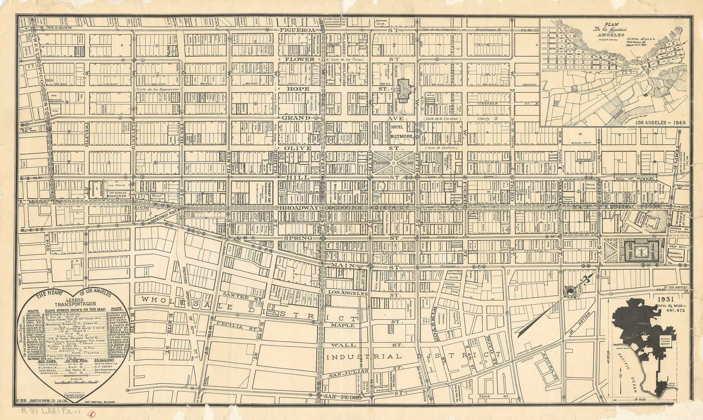
This is the map of downtown, courtesy of The Los Angeles Public Library with the Ord survey of 1849 as an insert. You can also see City Hall built on the streets that were configured in 1928. Click on map to see a larger version.
A billboard on Sunset Boulevard in Los Angeles welcomes travelers to Dodgertown. Dodgertown is not a town although it has its own zip code, thanks to the Los Angeles City Council. It is a stadium and nearby Dodger-owned property. If the Mayor leaves City Hall at 200 North Spring and drives along Sunset Boulevard to Stadium Way and then up through Dodgertown, he will travel along the trunk of what was called El Camino Viejo in the now City of Los Angeles.
When the first Europeans arrived in Southern California, they encountered a plain of tough chaparral – the plants impenetrable in their hardness and thickness — ground squirrel holes, rivers that were then much more like rivers than they are now, big rocks, steep hills, creeks and marshes. The explorers traveled through this rough terrain on a native trail, guided by natives, and greeted by friendly natives that presented them with trays of seeds. The trails the explorers traveled along were eventually called El Camino Viejo. El Camino Viejo was composed of several trails that all came into aboriginal Los Angeles and left from it.
The aboriginal village of iyáangẚ — meaning “place of poison oak” and spelled Yang Na by the Spanish – was located about where City Hall stands. Yang Na was one of the base villages for El Camino Viejo.
By the early 18th century, El Camino Viejo was an ox cart route following the middle branch (Cahuenga Pass) through the San Fernando Valley to El Tejon and then down through the Central Valley very roughly following the route of the Five freeway to Oakland, although up in the Santa Clarita Valley, a branch went towards Ventura, a branch or twig perhaps that the first explorers had followed.
El Camino Viejo in what is now downtown Los Angeles, Dodgertown, Hollywood and Mid-City, was actually comprised of three branches — possibly four – with the poison oak place as the center, acting something like the roundhouse of a railroad only for barefoot people instead of trains.
On the west side of the Los Angeles River, El Camino Viejo branched north of Los Angeles after leaving Yang Na. The middle branch went towards the Cahuenga Pass in a northwesterly direction. The left branch went in a rather westerly direction, in the direction of the Pacific Ocean, past the La Brea tar pits on what would become Wilshire Boulevard. About the westerly branch, Kevin Starr wrote in Material Dreams: Southern California through the 1920s (Oxford University Press 1991):
“In pre-European times, the Shoshonean residents of Yang-na in the Los Angeles Plain traveled the trail to fetch tar for caulking and sealing. From there the trail continued west to the seaside villages of the fishing tribes, who traveled inland to the tar pits as well. The Spanish used the trail in 1769 when they first explored the region, and by the end of the Hispanic era it had long since become El Camino Viejo, the Old Road.”
The 1769 expedition of Spanish explorer Gaspar de Portolá began at the native village of Yang Na. Friar Juan Crespi accompanied the expedition, and he named the river that passed near the Indian village El Río de Nuestra Señora La Reina de Los Ángeles de Porciúncula. Crespi chose that name, which translates as The River of Our Lady Queen of the Angels of Porciuncula, because it was the name of a special annual feast day for the Franciscans, which the Portolá party had celebrated the previous day.
Portolá took the left branch and skirted the Santa Monica Mountains at least part of the distance.
Miguel Castanso, an engineer, accompanied the Portolá expedition. In his diary, Castanso wrote that they forded the Los Angeles River, “which descends with great rapidity from the canyon through which it leaves the mountains to the plain. We directed our course to the west-southwest over high level ground, and after a march of three leagues, we reached the watering-place, to which we gave the name of the Ojo de Agua de los Alisos. This was a large spring situated in a marshy place where there stood some alder trees of very large girth; the marsh was covered with grass, fragrant plants, and watercress. Hence the water flowed through a deep ditch towards what we saw on this day’s march appeared to us most suitable for the production of all kinds of grains and fruits. On our way we met the entire population of an Indian village engaged in harvesting seeds on the plain.” http://www.scvhistory.com/pico/costanso-diary.htm. (Retrieved 12/23/2015)
La Cienega means a spring in a marshy place, and the location called Ojo de Agua de los Alisos is California Registered Landmark – 665-Portola Trail Campsite No. 2 at 325 La Cienega Boulevard between Olympic Boulevard and Gregory Way.
From La Cienega, the party went to Ojos de Agua del Berrendo (A “berrendo” is an antelope). This campsite was around where UCLA is today. Castanso described the place as a low hollow near the seacoast, inhabited by “good natured” Indians, who brought them trays of seeds, nuts and acorns.
“The scouts who had set out to examine the coast and the road along the beach returned shortly afterwards with the news of having reached a high, steep cliff, terminating in the sea where the mountains end, absolutely cutting off the passage along the shore. This forced us to seek a way through the mountains, and we found it, although it was rough and difficult. We then set out from the Ojos del Berrendo in the afternoon, and, directing our course to the northwest towards the point where there appeared to be an opening in the range, we entered the mountains through a canyon formed by steep hills on both sides. At the end of the canyon, however, the hills were somewhat more accessible and permitted us to take the slope and, with much labor, to ascend to the summit, whence we discerned a very large and pleasant valley.” The following day they camped near to what is now Castaic and then went west, roughly along today’s route 126 past today’s Fillmore to what would be Santa Paula and then to Ventura.
In Starr’s The Dream Endures: California Enters the 1940s (Oxford University Press 1997) he wrote that the Malibu Chumash also used the trail that was to become El Camino Viejo, which was to become the route that began at Westlake along Wilshire Boulevard. Chumash people had inhabited Los Angeles for about 9,000 years.
La Brea Woman, the only human whose remains have been found in the tar pits, is about 10,000 years old. She was interred with her dog. La Brea Woman was a young female who stood less than five feet tall. A forensic artist made a two dimensional reconstruction of La Brea woman’s face. Unsurprisingly, the artist concluded the woman had Native American facial features.
The right branch of El Camino Viejo went through the hills in a northeasterly direction, and this branch went eventually to the north, through the San Fernando Valley, and up to what was then San Antonio, and is now a district in Oakland.
Assuming eminent historian H. H. Bolton was correct, the January 1776 Juan Bautista de Anza expedition (“Anza”) left the San Gabriel Mission, arrived at Yang Na, and from there traveled to the bottom of the last Griffith Park hill that looms above the Five Freeway, and then turned west on a trail that became known as El Camino Real, now the Ventura Freeway and went up – roughly – what is called Highway 101. Before that, the route through the San Fernando Valley was part of El Camino Real, the royal road. All Spanish roads belonged to the king of Spain. This route was most likely originally part of a network of Indian paths, so really a part of El Camino Viejo.
The Silver Lake Reservoir was at that time a meadow, through which a creek ran. The Anza expedition could have watered their animals at the creek, then traveled across what is now Rowena to what is now Los Feliz Boulevard, entered what is now Griffith Park, and stopped for the night near the Los Angeles River. The route marked on the map below shows slash marks indicating what would become Los Feliz Boulevard, which ran at the base of the Griffith Park hills to the last hill and the Los Angeles River. The drawing of what looks like a sun on the river would have been the Anza stopping place for the night.

Feliz Rancho Deseno map. This was prepared to prove ownership under Congress’s Land Act, the trials of which were held in San Francisco. Land Act cases were pretty much over by 1860, so it was most likely made between 1851 and 1860.
It is possible – although a little less likely, as explained below — that the easterly branch of El Camino Viejo left Sunset at what is now Griffith Park Boulevard or Hyperion (parallel streets). That route would have taken Anza through a narrower meadow between “Bohemian Hill” and the Los Feliz hill on the other side. Into the early twentieth century, a creek ran through that pass between hills, and there was a mill that was run by water at about where Child’s Court is today. Anza could have watered the animals at that location as well.
If Anza followed Hyperion/Griffith Park, they probably would have turned at about where the Walt Disney Studio (now Gelson’s) was located and gone from there to Los Feliz Boulevard to the resting place that was to become part of the Rancho Feliz, and which is now Burbank.
Either the Griffith Park Boulevard route or the Silver Lake route would have been the one celebrants took from the Feliz Rancho every Christmas to the pueblo of Los Angeles.
If other Anza historians are correct, the Anza expedition took the middle route through the Cahuenga Pass.
A fairly straight route went from a location near the western bank of the Los Angeles River to what is now Fern Dell in the Los Feliz district of Los Angeles. The route appears on a drawing of the Feliz Rancho, granted as grazing ground by Governor Fages in 1788. That route is now Los Feliz Boulevard, which passes the William Mulholland memorial fountain. Before the recent sustained drought, electric lights colored the water purple, then blue, then green, yellow after that, red after that and then purple again. It had the popular name of “the Kool-Aid fountain.” Near its base is a large tube, referencing the zanja that once brought water from the river down by the Broadway Bridge. Mulholland started in Los Angeles as a worker on the zanja. He became a self-taught engineer and designed the Aqueduct, which brings water to the San Fernando Valley from the Owens River. In the film Double Indemnity, Barbara Stanwyck drove down Los Feliz Boulevard towards the Glendale train station at night, with murderous intent.
A village of native people now called the Tongva once stood at the entrance to Fern Dell drawn there by the year-round spring. Archeologists believe it was a meeting place for Los Angeles Indians.
A little further to the west of Fern Dell is the entrance to the Cahuenga Pass, now occupied in part by the Hollywood Freeway. Another village, called Cahuenga by the native people, stood at the other end of the pass.
Because of the importance to native people of the Cahuenga Pass, the Los Angeles River, and Fern Dell, I believe the Los Feliz Boulevard route was an extension of El Camino Viejo, the Old Road, that began near City Hall at what was once the village of Yang Na, a central trading area for the native people.
In The Story of Pershing Square (Title Guarantee and Trust Company 1931), title researcher and amateur historian W. W. Robinson wrote about El Camino Viejo, using a drawing that Robinson or his wife Irene made of a portion of the “Plan de La Ciudad de Los Angeles Surveyed by E.O.C. Ord USA” as evidence that an old Spanish route went through the edge of what would one day be Pershing Square.
Close scrutiny of the actual Ord map, below, which is larger than the Robinson sketch, shows that El Camino Viejo indicates the route began in downtown at Yang Na.

The Ord map, made in 1849
The accompanying Los Angeles City Map No. 1 is too small to adequately see El Camino Viejo. It is in the Los Angeles Public Library on-line map collection at http://www.lapl.org/collections-resources/visual-collections/plan-de-la-ciudad-de-los-angeles-1849. (Retrieved 12/13/2015) and the original is in the City’s archives.
If you go to the site by copying and pasting the link, a tiny magnifying glass icon should appear. By moving it to the area near the squiggly line that comes down from hill near the top of the map, you can see a trail that goes through proposed lots. You can see that the lot heads into a road established by 1849, that ends in a triangular lot. That empty space was adjacent to the Los Angeles village, as it existed at that time. The end of that triangle was the beginning of the old road in downtown Los Angeles.
From the Ord map’s scale at the bottom, it appears that one-inch on the original map equaled one mile. Each segment of the blown up scale measures one inch. If drawn to scale, the branch over the hills was 2.5 miles from Grasshopper Street. Figueroa was Calle de los Chapules or Grasshopper Street. Sunset now skirts the hills, so the pass into the San Fernando Valley was 2.5 miles from the intersection of Figueroa and Sunset. Silver Lake Boulevard and Sunset is 2.7 miles from Figueroa and Sunset. The Cahuenga Pass is 8.8 miles from Figueroa and Sunset.
Ord Street is in present day Chinatown, a brief ascent beginning at Phillipe’s. The street was named after engineer Edward Ord posthumously sometime in the late 1880s or early 1890s. Edward Ord, who completed the plan, was considered a mathematical genius and appointed to the United States Military Academy by President Andrew Jackson. He assisted in the survey of Sacramento that created the future capital city’s extensive downtown street grid in 1848. The City of Los Angeles government commissioned the Ord survey, so I assume that the scale was correct. If Ord’s map is to scale, the right branch turned through the hills along present-day Sunset past Elysian Park and Dodger Stadium, and turned east at Silver Lake Boulevard.
The location of the source of El Camino Real and its route both to San Pedro, and its route through Silver Lake to about where Burbank is and then west again to merge with El Camino Real and then up roughly the route of the Five Freeway, and also past Santa Clarita over the Old Tejon Pass all the way through the valley to roughly the route of the 580 to Oakland, suggests that Yang na was a significant native village, and that the people now called the Tongva traveled long distances on foot through California, trading with interior valley tribes, and meeting up with Ohlone people in the Bay Area. The Ohlone people inhabited the coast from the San Francisco Bay to the lower Salinas Valley, which includes Paso Robles. The Camino Real portion of the old road took the natives to Chumash villages. The Chumash people lived on the coast from Malibu to Paso Robles, in the Salinas Valley.
The Chumash had settled in what is now downtown Los Angeles about 8,000 B.C., which suggests La Brea Woman was Chumash. The Tongva people – some prefer the autonym “Kizh” — moved from Nevada to Southern California about 3,500 years ago, displacing or absorbing the Chumash. It makes sense that the routes between Los Angeles Indians (Tongva/Chumash) and the Chumash and Ohlone people continued up to the time of the Spanish explorations at the end of the eighteenth century.
Robinson wrote, “It (El Camino Viejo) had continued along the base of low, bulging hills whose curve led to plains that rolled up on the north to the high blue limits of modern Hollywood and Beverly Hills and on the west to white shimmering horizons….”
“For a century thereafter the road taken by Gaspar de Portolá through the Los Angeles region – or, rather, the road that developed therefrom – was the main highway for parties traveling northward. One fork – the principal (El Camino Viejo) led through the Cahuenga Pass and then to Encino, San Fernando and San Buenaventura. . . . Juan Crespi, diarist of the Portolá expedition, writes of the road through Los Angeles as if it were already in existence. It is probable that the scouts of the party followed old Indian trails connecting the aboriginal brush-hut villages at Los Angeles with those at Cahuenga, Playa del Rey and in the San Fernando Valley.
“The location of El Camino Viejo … with respect to the present-day city (in 1931) is shown on the map of the 1849 survey made by Lieutenant Edward O.C. Ord. Leaving North Spring Street at First, it extended southwesterly, crossing the present Hill Street at Fourth, touching Pershing Square at Fifth and Olive and leaving Figueroa between Seventh and Eighth.” The Ord map, however, shows the old road extending northwesterly not southwesterly.
The shaded bulges that represent hills surrounding the pueblo on both the drawing and the Ord map were Bunker Hill (it rises above Pershing Square) and Fort Moore Hill before they were lowered, and it is at about the Bunker Hill location that the old road touched on what would one day be Pershing Square.
A significant creek — according to both the actual Ord map and the Robinson sketch — flowed from Bunker Hill into downtown Los Angeles, crossing the edge of Pershing Square at the same place as a design of falling water is built into the concrete floor of the park today.
When American botanist and geologist William Henry Brewer traveled through Los Angeles in December 1860 as part of the State’s geological survey of California, the town of Los Angeles was composed of 3,500 people. He camped on a hill a mile from the town as it was then, and he could see from his campsite both the Pacific Ocean and the San Gabriel Mountains. The hill later called Bunker Hill was about one mile from the plaza downtown.
On Bunker Hill, wealthy American families built Victorian mansions. The short funicular railway called Angels Flight went up the hill. The very wealthy left, some of the mansions came down. Tenements went up. The City condemned the businesses and houses on Bunker Hill and tore them down. For a few years, stairways disappeared suddenly in dirt plots, and then they were gone. Multi-story office buildings then rose on the hill, and these buildings form the City’s iconic skyline, background to many films and television shows.
El Camino Viejo appears on the Ord map to cross at an angle 4th, 5th and 6th Streets, and to have an origin as a branch of Spring Street before it joins Main Street. Main and First intersect at the location of today’s City Hall, the location of Yang Na.
In 1926 — for construction of City Hall — the city reconfigured the streets. Teams of workers smashed and destroyed Los Angeles’s original American buildings between First, Temple, Spring (Once called “Primavera”) and Main Street. The pre-1926 configuration of streets formed a triangle, which is the triangle shown in the Ord plan as the source of El Camino Viejo, the area in the park in front of City Hall. The streets now form a rectangle.
Before this massive demolition, the triangle was the heart of commercial Los Angeles: Temple Square. Lawyers, bankers, photographers and hatters occupied the buildings overlooking the open space where Main, Spring and Temple Streets converged. The open space corresponds to the beginning of El Camino Viejo on the Ord map.
Jonathan Temple – a Massachusetts-born merchant — moved to Mexican California in 1827, converted to Catholicism, married Rafaela Cota, and took the name of Juan Temple. In 1843, he purchased Rancho Los Cerritos in Long Beach from his wife’s family. His 1844 adobe survives as part of Rancho Los Cerritos National Landmark. In 1866, Temple sold the ranch to Flint, Bixby & Co., which converted the ranch from cattle to sheep.
Temple opened the first general store on the northwest corner shortly after his arrival in Los Angeles in 1827. Across the street, he built the Temple Block, an agglomeration of buildings that began in 1858 as a two-story adobe structure. In 1860 Temple installed the city’s first paved sidewalks, built of a brick base, topped with asphalt, and then sprinkled with sand. In 1861, he planted some of the city’s first street trees (Peruvian peppers) outside his general store. In 1871, a three story Italianate structure replaced Temple’s old adobe building. Down the street was another commercial complex, the Downey Block. Three years later, the first streetcar line opened with Temple Square as its northern terminus.
“Today (again, that was in 1931),” wrote Robinson, if one walks through Pershing Square and thinks leisurely of the old sandy highway that once clipped off one corner and cut across the Biltmore Hotel site (The Biltmore has not been an empty site for a long time, and the public can walk through the hotel.), a long procession of persons who once used this road will crowd the mind.”
A highway is any public road, but El Camino Viejo began as a path followed by native people that walked, unaccompanied by animals. There are a large variety of soils in the Los Angeles area, including sandy loam, Santiago silt loam, Fresno fine sandy loam, adobe soil, Galveston clay, and peat, some with underlying gravel.
Later in his slender book on Pershing Square, Robinson wrote about the area the city of Los Angeles designated as a park in 1866:
“It remained a convenient camping ground for travelers coming in over El Camino Viejo. Campfires sent up their wreaths of smoke and filled the evenings with their glowing spots. Mary E. Taft recalls vividly this period. Having crossed the plains herself with her father, Captain Hazard, in 1852-53, she used to enjoy chatting with the campers in the park who often enough had just made the sort of trip she had gone through as a very young girl. . . . The Square, with its high grass and mustard, also served as a place to stake out cows. Mrs. Taft at 91 (In 1931) still laughs over her being chased by a cow one day as she was taking a short cut through (the site that would become Pershing Square).”
After Ord completed his 1849 map, the city either auctioned off or gave away the plots of land through which the three branches on the map had gone. It is all part of downtown LA.
The Native American trails in California – as throughout the United States – began as routes that migrating animals had carved. Deer, for instance, followed the easiest trails in their season migrations from summer to winter pasturage. The routes travelers take today through California had their start before any human occupation of the land.
Without the trails developed by the native people over many thousand years, the Spanish explorers might have had to blindly climb through chaparral, with little idea about where they were going. If the Spanish had not created roads based on native roads, they could not have colonized this state. Without the Spanish – who depended heavily on both Indian guides and Indian labor – the Americans that arrived here beginning in about 1831, would have starved to death.
The long procession of human beings traveling along the three branches of El Camino Viejo in the downtown area begins with 10,000 years of bare foot Indians, probably walking single file through the chaparral, leaving slight trace. Spanish explorers and soldiers on horseback followed two of the routes, although some may have gone over the Cahuenga Pass. Pack-laden mules accompanied them. The founders of the missions walked along the path. The American conquerors marched through to capture Los Angeles along El Camino Viejo and they signed the Treaty of Cahuenga on the San Fernando Valley side of that pass.
The Americans that did not arrive by ship came through the Cahuenga Pass with their horses and wagons and carts. For a time, Los Angeles remained, even though the government changed and the laws changed, Mexican. The young girl who would one day call herself Ina Coolbrith, was a member of one of the Christmas processions from the Rancho Feliz, and the procession would have started at what was the Feliz adobe and is now the Griffith Park Ranger station, along El Camino Viejo on the eastern branch along what is now Los Feliz, to either what is now Hyperion or Griffith Park Boulevard, to what is now Sunset, to the pueblo church: caballeros riding their horses with silver inlaid saddles, women in long dresses carrying lit candles.
Julian Chavez purchased land in Elysian Park in 1844, the land that is now Dodgertown. He obtained permission thirty years later to sell his land in parcels, and the houses built in the Elysian Park hills became the villages of Bishop, La Loma and Palo Verde. They continued the religious processions; the lit candles, peacocks and dogs crossed the paths between the houses. White flowers grew over the houses. Children rode down the grassy hills on cardboard boxes. Young men fought in World War II, and not all of them came home. The Zoot Suit Riots began in Chavez Ravine. The Los Angeles Housing Authority purchased Chavez Ravine to build public housing, through its power of eminent domain. The City instead sold Chavez Ravine to the Dodgers, and the Dodgers leveled hills to build the stadium.
The Hebrew Benevolent Society built the first Jewish cemetery in Elysian Park in 1853. You may see the plaque indicating the original location of the cemetery behind the old Armory building. In 1901, the B’nai B’rith congregation’s president donated 30 acres of land across the river in East L.A. for a cemetery. Over the following eight years, the congregation moved remains and stones to the Home of Peace Memorial Park, at 4334 Whittier Boulevard.
In 1882, Griffith J. Griffith – his statue stands at the entrance to Griffith Park on Riverside Drive near the entrance to Griffith Park, cattycorner to the Kool-Aid fountain — purchased the Rancho Feliz.
In 1885, Griffith and English naturalist Charles Sketchley brought 34 ostriches to an oak-dotted 680-acre site on the eastern bank of the Los Angeles River, about where Anza probably camped in 1776. The commercial farm raised the ostriches primarily for their feathers, which were very popular ornaments on women’s hats at the time.
In 1885, The Los Angeles Ostrich Farm Railway Company – owned by Griffith and Sketchley –obtained the franchise to build a rail line from the Sister’s Hospital overlooking Sonoratown (now New Chinatown), at the intersection of North Main and Bellevue to the Ostrich Farm.
Before it was completed, the Los Angeles County Railway Company absorbed it. The tracks ran down Sunset, then called “Elysian Street,” turned at the junction or “Y” in the Northwest corner of the City limits, which corresponded to the original legacy land for the pueblo inherited from the Mexican government. This area is now called “Sunset Junction.” The railroad reached the Ostrich Farm in 1888. The train went along the route now known as Griffith Park Boulevard, turned left at Griffith Park Boulevard and Hyperion (Gelson’s Supermarket, previously Mayfair and a gas station, and before that the Walt Disney Studio) to Los Feliz Boulevard, through the “paper town” of Ivanhoe, now called the Silver Lake district, to Los Feliz Boulevard, and from there through the Rancho Feliz to the farm. (There were many “paper towns,” which included Ivanhoe, Sunset, Cahuenga and Kenilworth, towns that existed only on developers’ subdivision maps.)
The Los Angeles Pacific Balloon Route later traveled from what had been Yang Na along Sunset, traveling along the old Ostrich Line route, and thence to Santa Monica and down to Sawtelle, to Santa Monica, Venice, Playa del Rey and Redondo Beach.
In 1896, after the crash of a development boom – the boom that had led to the 1880s paper towns – Griffith donated the land to the City for the creation of Griffith Park.
Off Sunset in the Edendale Valley between “the bulging hills,” Mack Sennett’s Keystone Cops careened madly on oil slicks, and Charlie Chaplin invented the character “the little tramp” in 1914. The Electric-Glendale (built in 1904) that passed through that once-idyllic valley led to the end of the Sennett Studios. The grinding noise of the train’s wheels and the occasional hoots of its whistle could not, at that time, be concealed. The branch to the furthest right of El Camino Viejo as it passes through Los Angeles could have passed along this route, but only if the Orr map scale was incorrect.
The Spanish silent film star Antonio Moreno and his wife Daisy Canfield developed the western hills above El Camino Viejo in the 1920s in the Silver Lake district. On the other side of El Camino Viejo, comics Laurel and Hardy chugged up municipal stairs pushing a piano in the film The Music Box Stairs.
At the beginning of this essay, I suggested there might have been a fourth branch of El Camino Viejo. That is, Anza stopped at the Mission San Gabriel before heading to Yang Na.
Father Serra chose the site for the initial mission, which was about eleven miles from the primary native village in the area. The Mission was the base for the first settlers to walk to what would become the pueblo of Los Angeles. Given the roughness of the terrain and the difficulty of hacking through chaparral, I think it is likely that an eastern branch of the El Camino Viejo came from the direction of the San Gabriel Mission to Yang Na.
If you live in Los Angeles or travel to Los Angeles, you drive along parts of El Camino Viejo. You drive over the deer paths, the Indian trails, Spanish explorers’ routes, through the Mexican town, along pioneer routes, past Victorian mansions, along the electric car routes, past Dodgertown, and into the present.
Selected Sources
http://www.erha.org/laandp.html. (Retrieved December 14, 2015)
Honey van Blossom, “Honey explains why we have the Silver Lake neighborhood, August 1, 2013. https://boryanabooks.com/?p=3427. (Retrieved December 14, 2015)
Howard Kuntsler, The Geography of Nowhere – The Rise and Decline of America’s Man-Made Landscape (First Touchstone Edition, New York, 1993)
Nathan Masters, “City Dig: The Ostriches of Griffith Park.” http://www.lamag.com/citythinkblog/citydig-the-ostriches-of-griffith-park/. (Retrieved December 14, 2015).
http://english.glendale.cc.ca.us/ostrich.html. (Retrieved December 14, 2015)
Comments
Leave a Reply
You must be logged in to post a comment.
Honey on the road to San Francisco with some of the Spanish explorers
NOTES FROM ABOVE GROUND
By Honey van Blossom
(Honey is a Belgian Marxist former strip-tease artiste)

"Cities of the Golden Gate," Raymond Dabb Yelland, 1893. Most illustrations can be enlarged by clicking on them.
Prologue to the story of the Spanish exploration and settlement of California
Seasonal migrations of animals now extinct in California probably created the roads the native people used before the Spanish land exploration of California. “The heyday of giant mammals in North America was the middle and late Pleistocene, an epoch that started 2.6 million years ago and ended 11,700 years ago, around the time the Earth was thawing out from the Ice Age. The gigantic beasts, which migrated from Asia across a now-vanished land bridge called Beringia, are known as Rancholabrean megafauna, after the famous La Brea tar pits in downtown Los Angeles — the graveyard of thousands of saber-toothed tigers, giant bison and other extinct animals.”[1]
The seasonal migrations of the large mammals may have created the substantial roads used by the indigenous people after their arrival.[2]
Paul S. Martin and Richard G. Klein argue that Paleoindian over-hunting led to the extinction of the megafauna.[3] Others argue that climate change was responsible for mammoth and mastodon extinctions. As the last major glaciation ended around 12,000 years ago, climate warmed too quickly for the megafauna to adapt.

