
Honey Talks About Where Los Angeles Began. Part 2
NOTES FROM ABOVE GROUND
By Honey van Blossom
(Honey is a Belgian Marxist former strip-tease artiste)
Part 1 of “Where Did Los Angeles Start?” looked at the primary Tongva trading village of Yang-Na, located about where the Los Angeles Civic Center is today. Part 2 describes Los Angeles as the first emigrants from the United States saw the pueblo (until 1835) and then as they saw the city (after 1835).
In Edgar Allen Poe’s short story “The Case of The Purloined Letter,” police detectives search for a stolen letter. They look behind wallpaper and examine tables and chairs with magnifying glasses, but they cannot find the stolen letter in the hotel room where the blackmailer/thief stays. The fictional private detective C. August Dupin later finds the letter hidden in plain sight hanging on a ribbon used to hold letters but with a handmade envelope that had nothing to do with the letter inside.
The website for Olvera Street calls it “the first street in Los Angeles.” It wasn’t. The first streets were called “o” and “n.” Olvera Street was called Wine Street until 1877. If you drive to that tourist marketplace called Olvera Street today along Sunset headed towards Terminal Annex, however, a road sign next to the market place states, “Olvera Street. Established 1930.” The city both misleads you and sets you straight.
California historians place the original pueblo proper (the plaza and surrounding structures) in different places: on top of the Indian village of Yang-Na, at El Aliso, the giant sycamore, “behind Union Station,” around the Twin Towers jail on Vignes, and on the hill a bit above the present pueblo at about Parking Lot No. 2. A couple of writers gave up trying to figure it out.
Where it was located – where it is, parking lot no 2, the parking lot for the Twin Towers jail, or somewhere else – it was settled in the months between June and the end of September 1781. The colonists built brush houses, planted fields of crops and built a toma – a dam and head works – before the rainy season that was to and perhaps did begin in November 1781. Two years later, England’s thirteen colonies on the other side of America ended their war for independence.
William D. Estrada, curator of El Pueblo de Los Angeles Historic Monument, in Los Angeles’s Olvera Street (Arcadia Publishing 2006):
“The present plaza is the third, or even fourth, location of the plaza. It was laid out between 1825 and 1830. On the north side of the plaza, a short street named Wine or Vine Street ran in a north-south direction. It ended at a bluff leading down to the Zanja Madre (Mother Ditch), which flowed diagonally from northwest to southwest and provided precious water for the young pueblo. Houses were built on Bath Street, Vine Street and Alameda.
“Adobe houses were also built on the south and east sides of the plaza. On the west lay the church (completed in 1822)…”
Estrada’s conclusion that the present plaza was laid out between 1825 and 1830 may be correct; however, the Avila adobe, which is located on today’s Olvera Street, was built in 1818. The pueblo was first settled between June and September 1781, so the Olvera Street location was not the original site. If Estrada is correct, then as much as 49 years earlier, the plaza was somewhere else, a not-Olvera Street location.
The Catholic Church states that there was an earlier church building somewhere in the vicinity of “what is now the corner of Cesar E. Chavez Boulevard and Broadway.” The Church website, however, refers to a chapel some 1400 square feet begun in 1784, three years after the settlement began.
A chapel is traditionally a smaller religious space than a church. The “church” refers both to the worship space in an architectural sense as well as the congregation as a collective of people. A priest came out from the San Gabriel Mission to the chapel from 1784 to celebrate mass once a week. There was no priest installed in the pueblo until after La Placita was built.
The location of the chapel – North Broadway and West Cesar Chavez meet in Chinatown – supports a conclusion that the original pueblo was cornered at one end by La Placita’s cornerstone and at the other by a chapel, that was to be replaced by a regular church. This is the Parking Lot No. 2 location for the pueblo proper (Plaza and plaza-facing buildings) at least before the church and the new plaza relocated.
There are, however, problems with thinking of the Parking Lot No. 2 pueblo as the very first pueblo proper, no matter what the Church website says. First, the Zanja Madre was a fairish walking distance from the Broadway/Chavez chapel and Parking Lot No. 2. Governor Felipe de Neve determined the first pueblo should be built on a moderately high elevation, and so anywhere on a hill would have fallen within the ambit of Neve’s rule. Still, in the early days of the pueblo when the Indians had not yet taken on almost all the labor, building on a hill that was also a distance from the zanja would not have been a good idea.
Second, it was about 1.2 miles, walking through the Cornfield, from the toma/mouth of the Zanja Madre to the chapel at the corner of North Broadway and West Cesar E. Chavez Avenue. The first settlers had three months at most to build the toma and zanja, prepare the land for crops, and build their huts. It is not at all likely that they dug the zanja for 1.2 miles in that three- month period. The original pueblo would have been closer to the toma.
On August 18, 1814, Franciscan Fray Luis Gil y Taboada placed the corner stone for the church that was, as Estrada says that it was, completed in 1822. The church was named La Iglesia de Nuestra Señora la Reina de los Ángeles, and is still popularly called “La Placita,” which means “the little plaza.” It is now called Our Lady Queen of the Angels Catholic Church. Its address is 535 North Main Street.
La Placita faces the current plaza, which was originally laid out as a rectangle and became a circle sometime after the American occupation with much better landscaping. La Placita was rebuilt on its first location using original materials in 1861, eleven years after California was admitted to the Union, just as the American Civil War began.
Roman Catholic church ceremonies involving cornerstones are that before a foundation is built for a new church, the foundation is marked and a cross set up to indicate where the altar will be. The bishop or his delegate sprinkles holy water on the foundation site and the cornerstone. He engraves crosses on the stone.
Several sources report that Fr. Gil placed the cornerstone for La Placita in the ruins of an older church. It is unlikely Fr. Gil performed this ritual in ruins. A cornerstone is set up in a new church. Besides, “ruins” suggests that an earlier church – the existence of which has never been suggested – fell down or burned down or washed away.
The roof of the church in the pueblo (The roof beams at least were put together in 1819) was wood, so a church might have burned, although there is no evidence that it did. Mud brick does not burn much although the tar settlers used on roofs could have burned. A flood wouldn’t have destroyed an earlier church, but there is again no evidence that it did. Earthquakes are always a possibility in Los Angeles. Maybe an earlier church fell down but the Catholic Church identifies La Placita as the first church in Los Angeles.
J. M. Guinn, in “Historic Houses of Los Angeles,” Annual Publication of the Historical Society of Southern California, Los Angeles, Vol. 3, No. 4 (1896), pages 62-69, described an old jail on what was then a hill above the Olvera Street Pueblo, which Guinn called The Cuartel Viejo. “Cuartel” has several meanings, none of which is “jail.” Its first meaning is a barracks. “Jail” in Spanish is “la cárcel.” Guinn wrote that the structure had started its life as a guardhouse and later became a jail but the structure probably started as the place the soldiers lived.
Guinn concluded that the Cuartel Viejo had existed since the founding of the pueblo.
What Guinn discovered was evidence of a building from an earlier pueblo location than the Olvera Street location, built on higher ground than the Olvera Street site. That pueblo site, called “El Pueblo Viejo” by the time that Guinn wrote, existed from 1814-1817. Maybe it is still there, only without the plaza in the middle: it is the Parking Lot No. 2 location that extended to the chapel on what is now West Cesar Chavez and North Broadway.
Guinn’s explanation that what he believed was the original pueblo was destroyed in a flood makes no sense: no one was likely to have decided to move downhill, closer to the river. The Olvera Street plaza area is on a lower elevation than El Pueblo Viejo was.
Guinn wrote the Cuartel Viejo was in ruins by the 1830s.
Guinn wrote that he did not have a clear explanation for why La Placita was moved in 1818.
There is, however, no evidence La Placita was moved. There was only the cornerstone in 1814. The church may have been swiveled so that it faced what would be the present plaza when the 1814-1817 pueblo moved downhill, and that is why it took so long for the church to be built, and why the pueblo ayuntamiento used the services of Joseph Chapman as part of his probation for having been a pirate. The people of Los Angeles needed someone to figure out how to complete the church, which way may be how Chapman avoided the noose.
In 1821, Guinn wrote, Jose Antonio Carrillo petitioned the Comisionado for a house lot near the “new Temple which being built for the benefit of our holy religion.” Carrillo’s house was complete in 1825. Guinn’s evidence includes a record of the grant and also the E.O.C survey of 1849. He found that it was the only recorded deed since 1786. Actually, there were no clear deeds until sometime after 1840 because there was no survey until the 1849 Ord survey. The Carrillo house was “the most pretentious and aristocratic residence in the Pueblo at this time.” This house was demolished in 1869 for the Pio Pico house – a hotel. That structure still exists.
This development was the pueblo proper that the first foreigners, including men from the United States, encountered: a parish church, a plaza, and a collection of higgledy-piggledy sited unpainted mud brick flat roofed houses — some facing the plaza, others not, some built right on what was supposed to be a street. They walked on dirt streets, with no streetlights, eventually came across a dry goods store, then more stores.
The stores came about after Mexico won its independence from Spain. From that point Mexico changed governments every 8 months or so, leaving Alta California alone to do what the Californians wanted to do. Spain had greatly restrained trade with non-Spanish countries.
Creaking ox carts traveled to San Pedro and back with cattle hides and gold after the Santa Clarita discovery on the way to the sea, and with textiles, dishes, hair combs — whatever commodities people living in the general Los Angeles area wanted. The pueblo proper was surrounded by luxuriant green fields, olive orchards, vineyards, fruit trees growing all the way to the river, the mighty San Gabriel Mountains a hulking giant in the background, a big sycamore tree behind what is now Union Station. On the eastern side of the river, agricultural fields and nut and fruit orchards also flourished. An early photograph taken from Stone Quarry Hills in Elysian Park shows vineyards below the hills in what would be Frogtown and across the river from Frogtown abundant plants and trees grew.
Adobe houses, however, also stood out in the vast rancho lands outside of the pueblo, and also had been built in the area north of the pueblo proper since Spanish times.
In 1844, Julian Chavez, born in 1810 in New Mexico, acquired 83 acres of land from the city in parts of the Elysian Park area, but which is largely within the Dodger Stadium property. A small band of Chavez’s land was in Frogtown.
Around the bend of the river from Frogtown, past the toma, and along the zanja in the Cornfield, millstones ground the pueblo’s grain into flour at Stearns Mill. In 1853, William Dryden built a water wheel at the entrance of the area that would be known Solano Canyon to carry water uphill to a reservoir.

The Water Wheel is about 1860 at the entrance of what is now Solano Canyon
From the 1850s until the early twentieth century, the district now called Chinatown was Sonoratown; that is, in an area bordering The Cornfield and closer to the toma than the pueblo proper.
The district acquired its name after miners from Sonora, Mexico passed through there on their way to the gold fields in northern California. By 1850, the Americans succeeded in barring “greasers” – any Spanish speaking people but Antonio Coronel managed to get to the Sierra foothills and return to Los Angeles with a lot of gold before the ban – and some of the Sonoran miners settled in Sonoratown.
Many of the emigrant miners moved into existing adobes, which means that people had built homes outside of the pueblo proper before 1850; that is, by 1850s, houses stood at the edge of The Cornfield from about the entrance to what is now called Sonora Canyon down through what is now Chinatown.
Some of the miners built shacks in the backyards of the existing adobes. The adobes had been built in Spanish times, that is, from sometime after 1781 up to 1821. https://www.kcet.org/shows/lost-la/sonoratown-downtown-las-forgotten-neighborhood. (Retrieved 7/16/2016)
In 1866, Sonoratown butcher Francisco Sales de Jésus Solano purchased 87 acres of land from the city in what would be called the Elysian hills above the Cornfield for himself, his wife and their six children. In 1888, Alfredo Solano subdivided the southernmost, 17-acre parcel of Francisco’s property into the 100 lots that exist today. This property was known as Solano Tract — later Solano Tract No. 1 — and it is all of that part of present-day Solano Canyon between Solano Avenue and Casanova Street and south of the Arroyo Seco Parkway — now California State Highway 110, the Pasadena Freeway. http://www.solanocanyon.org/history-of-the-canyon.html. (Retrieved 7/1/2016)
The canyon is between Radio Hill and Buena Vista hill.
John D. Weaver’s Los Angeles: The Enormous Village 1781-1981 (Capra Press 1980) describes a 1820s and 1830s pueblo “bursting” with saloons, gambling dens and bordellos. His authority for this description was Sir George Simpson, Narrative of a Journey Round the World, During the Years 1841-1842 (Lea and Blanchard 1847).
Simpson wrote about San Francisco:
“But the population of California in particular has been drawn from the most indolent variety of an indolent species, being composed of superannuated troopers and retired office holders and their descendants.”
About Santa Barbara, Simpson wrote:
“In a word, Californians are a happy people, possessing the means of physical pleasure to the full and knowing no other kind of enjoyment.”
Also, “Implicit obedience and profound respect are shown by children, even after they are grown up, towards their parents. A son, though himself the head of a family, never presumes to sit or smoke or remain covered in presence of his father; nor does the daughter, whether married or unmarried, enter into too great familiarity with the mother. With this exception the Californians know little or nothing of the restraints of etiquette; generally speaking, all classes associate together on a footing of equality; and, on particular occasions, such as the festival of the saint after whom one is named, or the day of one’s marriage, those who can afford the expense, give a grand ball, generally in the open air, to the whole of the neighboring community.”
Simpson about Los Angeles:
“San Pedro is an open bay, which has no better claim to the character of a harbor than almost any other point on the coast, being exposed to both the prevailing winds, and being destitute of everything in the shape of a house or even of a shed. Its only recommendation is that it affords access to the Pueblo of Nuestra Senora, about eighteen miles distant, which contains a population of 1500 souls, and, is the noted abode of the lowest drunkards and gamblers of the country. This den of thieves is situated, as one may expect from its being almost twice as populous as the two other pueblos taken together (San Jose and Branciforte), in one of the loveliest and most fertile districts of California; and being therefore one of the best marts in the province for hides and tallow, it induces vessels to brave all the inconveniences and dangers of the open and exposed bay of San Pedro. In this village, the custom of making the bull and the bear bait each other, though common to the whole province, is peculiarly popular and fashionable – a custom which, by excluding human combatants from the arena, banishes entirely that higher interest which arises from the introducing of ‘man and man’s avenging arms’ into the national entertainment of the old country….The savage sport ends only with the death of one of the combatants, and perhaps of both….”
There is little in Simpson’s description of Los Angeles that supports John Weaver’s interpretation that the tiny city was bursting with bordellos, saloons and gambling dens before 1847.
Simpson shows us instead a picture of the city as inhabited by hospitable, smiling, dancing and music playing people, socially egalitarian but dependent on Indian labor. Probably some men drank too much brandy, and it sounds as if they were so bored they gambled over fierce battles between a bull and a bear. They also “ran the rooster,” which involved greasing a live chicken and burying it to its head and then trying to pull it out of the ground. Possibly they gambled at home, because Los Angeles was a city of adobe houses, and there were at least fifteen women listed as “Mal Vida” a few years later but no one other than Weaver has come up with bursting bordellos, saloons, and gambling dens in the 1820s, 1830s and 1840s.
After the American occupation beginning with the 1847 military occupation, no historian disagrees with the picture of the city as one with a lot of saloons and bordellos. For a time, there was a murder a day after California in those saloons and in the gambling dens, and there were only about 1500 people, including children at the time. If the craziness hadn’t stopped when it did, there would not have been any people left after five years
Weaver also described a city without shade trees. The poet Ina Coolbrith, however, who lived in the city from 1851 to 1861 (ages 10 to 20) described adobe houses with interior courtyards, and through open doors she saw interior courtyards that grew large pepper trees for shade. Pepper trees are not native to Southern California but became popular imports from Peru after 1825. They had fragrant, lacy leaves, drooping branches and small pink berries that resemble peppercorns. Pepper trees grew around the Mission San Gabriel and for a time were emblematic of Southern California.
Josephina Smith, later called Ina Coolbrith because her uncle was Joseph Smith, a Mormon leader, started school for the first time when she was fourteen at the first public school, which opened that year on the northwest corner of Spring and Second Street. Residents at the time complained that it was on the edge of the city, so Ina had to walk through farmland to get to her home in the city area.
Aleta George, in her Ina Coolbrith: The Bittersweet Song of California’s First Poet Laureate, (Shifting Plates Press 2015) wrote that Coolbrith said about walking home from school in Los Angeles:
“The day was tired out with the heat and I was glad to reach one of the small streets. Thro’ the pepper, lime and locust trees along the sides were drooping, the brea dripping from porch and roof eaves, and the sidewalks, of the same material, in a mood of such melting tenderness that the brown, bare-limbed little muchachos and muchachas no longer printed them with their small toes, but were resting their roly-poly bodies in the open doorways.”
Weaver:
“El Pueblo’s first foreigner, Jose Antonio Rocha, arrived from Portugal in 1815 and ran up an imposing home which was later to serve as the town’s first city hall. The first Angelinos from the United States were two pirates who came ashore in 1818 and promptly mended their ways. One was a black buccaneer, Thomas Fisher, who seems to have vanished some years later in the gold rush. The other was a blonde blue-eyed Bostonian, Joseph Chapman. His hometown and the republic its rebels had helped bring into being were so remote from his new Spanish-Speaking neighbors that they called him El Ingles (The Englishman.”
“Pirate Joe” (sometimes “Blonde Joe”) converted to Catholicism and married a Spanish wife. He is credited with building the roof of La Placita as part of his probation for piracy– taking a team of Indian workers to an area behind Mt. Wilson to cut timber for the roof in 1819. The name of the canyon is called Church Canyon, for the obvious reason. The Indians called him “Diablo Joe” because of his dexterity with an ax. Ten years later, he took them back to the mountains to get pine to build a ship. He built a seventy-foot long schooner.
Church Canyon became Millard Canyon. The following link takes you to the site for Millard Canyon. There is a photograph of Joseph Chapman and his wife Guadalupe Ortega y Sanchez circa 1847 on the site as well as directions to get to the canyon. http://www.modernhiker.com/2016/05/19/hike-millard-canyon-falls/. (Retrieved 7/26/16)
This was the beginning of an era of timber extraction from the San Gabriel Mountains, but it did not expand until after the Americans arrived and the population of Los Angeles increased. After then, unchecked resource demands devastated the mountains and disturbed the ecosystem so badly that the mountains remain subject to fierce fires.
Weaver:
“….It (La Placita) faced the new Plaza, which had been shifted to its present location in 1818, reversing the direction of the town’s growth. Instead of moving north, it had begun inching south.”
“Two enterprising Yanquis, John Temple and George Rice, opened the town’s first general merchandise store in 1828 on the southern edge of the town, the site of the present Federal Building at the corner of Temple and Main….
“Twenty-nine of the area’s fifty foreigners (other than Spaniards) hailed from the United States. Their ranks included not only Don Juan Temple but also Abel Stearns, another New England hustler. He trafficked in hides and wine, did a little smuggling on the side, and ended up as Southern California’s wealthiest landowner.”
According to J.M. Guinn, in “Los Angeles in the Adobe Age,” Annual Publication of the Historical Society of Southern California and Pioneer Register, Vol. 4, No. 1 (1897), Rocha’s adobe house (before he acquired a large rancho in 1828), had been on what would become the site of the Phillips Block.
Phillips Block was at the intersection of Spring Street and Hill Street. The Phillips Block, built in 1887, burned down in 1918. The streets are now named North Spring Street and North Hill Street, which places the Rocha adobe in today’s Grand Park, across from City Hall.
The American City of Los Angeles purchased an old adobe across from today’s City Hall. This corresponds with the location of Rocha’s adobe at the end of today’s Grand Park that faces City Hall, so that must be where it was. The 101 now passes between City Hall and the Olvera Street Plaza, so it is not evident unless you look at a map that only half a mile separates the current plaza from the end of Grand View Park.
On July 4th, you can sit on the lawn in Grand Park and watch the fireworks display in the night sky along with thousands of other people that are surprisingly polite when they are not driving cars. If you look behind you, you’ll see City Hall, lit with red white and blue lights for the occasion. You’ll be sitting where Rocha’s house was almost 200 years ago, when City Hall was still Yang Na.
Guinn writes in “Los Angeles in the Adobe Age” that the pueblo was walled. There is no evidence that it was walled, although the settlers walled the agricultural fields as a barrier against the pueblo’s grazing animals eating everything they grew. He also remarked that there were “predatory Indians,” but there is also no evidence of predatory Indians in the pueblo or near the pueblo. The Indians at Yang Na were mild. They accepted things.
Guinn: “By the beginning of the present century (i.e., by the early1800s – Guinn was writing at the end of the 1800s), the town had grown beyond its walls. As it grew, it straggled from its nucleus – the old plaza – in an irregular sort of way, without plot or plan.”
The river defined the pueblo. Water from the river irrigated the fields and later the orchards and vineyards. River water washed the settlers’ clothes and children. They drank the water. They threw garbage into the river and the irrigation ditches.
From an interview Los Angeles County Flood engineer James Reagan made in 1914 with J. E. Proctor of Long Beach, who had lived in Southern California since about 1874:
“In the early days, and up to within the last four years, the country was covered more or less with willows, brush fences, and in some places, lakes, marshes and other small growth. In those days the water would spread out all over the country, and the velocity was very much slower, it did no damage, and in many ways did good.
“It was not necessary to fertilize the land, as they are now doing. They raised 100 bushels of corn to the acre, but not now. In those days a crop of corn and California pumpkins were raised on the same land. Those pumpkins would grow so thick that it was difficult to walk around and step between them, while it was an easy matter to go all over the place and never step on the ground, stepping on the pumpkins. The largest I ever saw weighed 214 pounds, and on our place we raised one that weighed 206 pounds.
“So in this way the floods did a great deal of good. Each flood left a deposit of silt on the land that made the rich yields of those days. I am afraid the people will miss those floods, although in the last flood the land was washed very badly. That washing comes from the land being cleared off and having a freer run than before. There were no railroad embankments in those days to hold the water either, where it is now held up, and the volume contracted into a smaller space at the openings under the railroad. And too, a flood would break out and a strong current would cut across the country carrying things before it, and in the wake perhaps putting a channel that ruined the land. Therefore part of the flood carried the big amount of silt, but the deposits were left by the last part of the flood.” (Reagan, J.W. 1915. Consulting Engineer, Los Angeles County Flood Control Research, 1914-1915. United States Army Corps of Engineers. Huntington Library Manuscript Collections. San Marino, CA.)
On September 5, 1876, the first through train from San Francisco arrived in Los Angeles after traveling over the newly completed Tehachapi Loop. In 1876, Southern Pacific built the River Station (1876-1901) on The Cornfield. The Cornfield remained a rail yard until 1992.
The Glendale Narrows – an eleven-mile stretch of river from its bend at the last hill in Griffith Park to the Elysian Valley (“Frogtown”) to the location of about the Old Toma — was during Spanish, and then Mexican, and then American occupations, a marsh with islands in it. It is such a wet area naturally that, after the U.S. Army Corps of Engineers encased the river in concrete in 1938, the bottom did not harden. Trees and plants to this day grow in the otherwise concrete storm channel in the Narrows.
The Arroyo Seco (“Dry Creek”) watershed begins at Red Box Saddle in the Angeles National Forest near Mount Wilson. The beginning of the Arroyo Seco is a beautiful hiking area. http://www.summitpost.org/red-box/246212. (Retrieved 7/26/2016).
The Arroyo Seco flooded during rainy seasons. It reached its confluence with the Los Angeles River a little to the north of the tallest hill in Elysian Park. When the Arroyo Seco was full of water, the water in it tore down trees along its sides and contributed to the water flow in the L.A. River, bringing with it river sand and mountain minerals that enriched the surrounding land, demolished the toma, and filled the zanja with river sand.
Blake Grumprecht wrote:
“One early resident reported that the river had no confined bed in the Glendale Narrows until 1825, when the region was hit by a major flood that changed drainage patterns throughout Southern California. Floods were so common in the Narrows that once fertile bottomlands along the river were eventually abandoned as unsuitable for cultivation because they were so regularly covered with sand.”
Joe Linton, Down by the River: Friends of Los Angeles River Official Guide. (Wilderness Press 2005) and Blake Grumprecht, The Los Angeles River: Its Life, Death, and Possible Rebirth. (Johns Hopkins University Press, 1st Paperback Edition March 1, 2001) are excellent expositions of the river’s history; nonetheless, neither book provides authority that bottomlands were abandoned because they were covered with sand, other than that early resident’s report. See also, J. M. Guinn, “Exceptional Years: A History of California Floods and Drought.” (1886) On Jstor, “Free to anyone in the world”: https://archive.org/stream/jstor-41167825/41167825_djvu.txt. (Retrieved 7/6/16) The source of my information on the American City of Los Angeles’ water delivery system is a document prepared by the Wisconsin WPA Book Repair Project in 1939. William Ham. Hall, State Engineer, prepared the report in 1888. The title is The Second Part of the Report of the State Engineer of California on Irrigation and The Irrigation Question, published by the State of California. https://babel.hathitrust.org/cgi/pt?id=uc1.31822010637338;view=1up;seq=33(retrieved 7/9/16). This report sheds light on the possibility that a sand problem may, however, have affected the agricultural area through which the Zanja Madre waters flowed: The Cornfield.
The Cornfield is a popular name for what is now the Los Angeles State Historic Park. Before it was a park, it was a brownfield, and before that it was a train yard. One 1988 photograph and one 1889 photographs of the L.A. Cable Railways’ Downey Avenue Viaduct on the Los Angeles Public Library website reveal a small piece of The Cornfield as it was in the 1880s.

Downey Viaduct, courtest LAPL
Although called the Downey Avenue Viaduct, there was no Downey Avenue that crossed the river; rather, Downey Avenue was a street bisecting Lincoln Heights on the east side of the river. Downey Avenue on the east side of the river is now called North Broadway.
Broadway is one of the oldest streets in the city, laid out as part of the 1849 plan/survey of Los Angeles by E.O.C. Ord and named Fort Street. Fort Street began at the southern side of Fort Moore Hill (a block north of Temple Street) at Sand Street (later California Street, now submerged in the 101 Freeway). The name of Fort Street, from First Street to Tenth Street, was changed to Broadway. The rest of Fort Street, from California Street to First Street was changed to North Broadway. The Broadway Tunnel under Fort Moore opened in 1901, extending North Broadway to Buena Vista Street at Bellevue (French for Buena Vista). In 1909, construction began on a bridge across the Los Angeles River to connect Buena Vista with Downey Avenue. The City then changed the names of Buena Vista and Downey Avenue to North Broadway. See, “A Literary Fog, Los Angeles Times, November 30, 1909, and “Downey and Buena Vista Will Be North Broadway,” Los Angeles Herald, September 19, 1908. The Los Angeles Times story requires a subscription to the Times’ archives. The Herald story is at http://cdnc.ucr.edu/cgi-bin/cdnc?a=d&d=LAH19080919.2.127.5. (Retrieved 7/25/2016).
If you take the Amtrak bus from Union Station to Bakersfield, the bus travels to the Five Freeway along side streets south of The Cornfield. Old signage along this route says “Downey” but there is no Downey Street and there never was on the western side of the river.
In the photographs, an embankment leads up to the Los Angeles Cable Railway Co. tracks and viaduct. The land below looks covered with weeds or grass or low brush. Buildings, probably houses, cluster at the end closer to the river. Those buildings appear to be on what was called Toma Street.
The Capitol Milling building at what is now 1231 North Spring Street — the oldest brick commercial building still standing in Los Angeles — was built in 1883 to replace an older three-story adobe building called (Abel) Stearns’ flour mill, which Stearns built near the Zanja Madre in 1831. It became Eagle Mill sometime around 1856. The original flourmill used the zanja’s flow to pour its millstones. Capitol Milling went out of business in 1999. The building is now under the Gold Line viaduct.
The Huntington Digital Library offers a surveyed map of the Stearns Mill Seat, showing the location of the Old Toma and the zanja system that flowed through The Cornfields from George Hansen’s survey of the Stearns’ Mill property in 1856. http://hdl.huntington.org/cdm/search/searchterm/Stearns%20mill/order/nosort. (Retrieved 7/25/2016).
During the 1800s, waterwheels in the United States powered large flourmills. The mills’ millstones rotated against one another to crush grains into flour. Water from the river, via what the Zanja Madre, powered the mill. The water made an 18-foot drop in a three-foot wide brick conduit. See, http://libraryarchives.metro.net/DPGTL/archaeology/2004_relationship_zanja_madre_mta.pdf. (Retrieved 6/21/16) This research omits Abel Stearns’ construction of the mill in 1831, and begins with Eagle Mills.
The Old Toma, the pueblo’s first dam, originally built of brushwork, was at the western side of where the Broadway Bridge now crosses the river. In 1884, a flood tore out its wooden successor.
See, Chapter XXIII of engineer Hall’s report, “Los Angeles Works and Projects.” Chapter XXIII also discusses the Chavez (Elysian hills development) and the Feliz heirs’ legal claims (Rancho Feliz, some of which is now Griffith Park, donated to the City in 1896) to riparian rights for water from the Los Angeles River, among other engaging information about the history of the pueblo’s origin, which can be found elsewhere, and the fact that one of the branches or subsidiary branches of the zanja was used to transport the City’s sewage south to Sixth and Main where it was used as fertilizer. State Engineer Hall did not dwell on the sewage distribution.
According to Hall, in 1888, the Zanja Madre had 8 branches, and these branches had branches. The Arroyo Seco was a sand and gravel wash above the Zanja Madre. The toma was “an ordinary brush and sand dam.” The ditch extended over the bottomland and lower plain “somewhat more than two miles, on a course generally parallel with the river, and a quarter mile to a half mile therefrom; then getting back on the bench at the foot of the hills, and gradually out of the valley, for nearly three miles, arrives at a point on the bluff overlooking and about fifty feet above the river, and at the head of a pass on the south. From here, the east-side waters are diverted…”
The main supply zanja was a plain earthen ditch, six feet wide on the bottom, twelve feet wide at the top, and intended to carry three feet depth of water per second. “There are in the line of work three regular sand-boxes and gates for entrapping and sluicing out the sands brought into it and twelve flumes, across ravines and washouts, from twenty to two hundred feet long, each provided with a sand gate.” Through the city, all but 200 feet of the city, the ditch was either a concrete pipe or open concrete-lined ditches, parallel to city streets.
Clearly, there was river sand intrusion in The Cornfield caused by the toma and the Zanja Madre, but there is no evidence in Mason’s history that the settlers abandoned this area for agriculture, although they may have. The former name of California Street (now part of the 101) was Sand Street, which suggests a number of things, among them that the zanjeros deposited the sand from the Zanja Madre at that location, or that sand traveled along the zanja and stuck there on its own. There is evidence that, in later years, zanjeros using sluices, sand boxes and gates, cleaned the zanja of sand. This is primitive technology, dating from at least Roman times in Spain. The Spanish settlers, employing Indian labor, could have also kept water flowing through the zanja system. On the other hand, spillage from the zanja ditches after floods could have meant the abandonment of The Cornfield as an agricultural area.
The E.O.C. Ord survey or plan for Los Angeles prepared in 1849 shows agricultural land, including orchards and vineyards, south of the Olvera Street pueblo. In the area eventually referred to as The Cornfield, he does not identify any agriculture. On the other hand, Ord found it difficult to get the city to pay him, so perhaps he just did not fill in that area.
If the Americans moved the ditch water into pipes because of sand, the strong implication is that the ditch had not filled with sand before the American occupation. The Americans continued to use the zanja, the waters of which flowed downhill past the former Stearns Mill (New Chinatown area, once “Sonora Town”) through and below the present Olvera Street Plaza, and extended the zanja system through Plaza Abaja (Pershing Square) and also down Figueroa to the later-named Adams District.
There was another reason, which was not mentioned in Hall’s engineering report for problems with the zanja; that is, beginning in 1876, Southern Pacific Railroad laid train tracks in The Cornfields. The train tracks would have interfered with the flow of water through open ditches.
Southern Pacific Railroad built two train stations in The Cornfield: the first River Station (1876-1887), and a second River Station (1887-1901). The Cornfield eventually comprised the Southern Pacific freight rail yard. The original train line came south from Sacramento into Los Angeles along San Fernando, crossing the river at the bottom of the Narrows and angling along North Main Street. A myth arose that kernels of corn fell off the freight trains and grew into corn stalks between the tracks, and so it became popularly known as “The Cornfield.”
The freight rail yard is the backdrop in the last scenes of the 1942 film, This Gun for Hire. In the film,Alan Ladd runs away from the police over the bridge that once crossed the rail yard.
Moving backwards from the film to almost 100 years earlier: E.O.C. Ord wrote about his 1848 visit to Los Angeles in The City of the Angels and the City of the Saints, edited by Neal Harlow (The Huntington Library, San Marino, but Ord wrote his essay in 1856). He arrived at San Pedro bay on the Coast Steamer “Sea Bird” and boarded a stagecoach. Ord:
“Here we are rising the slope & now we can see the city of Los Angeles. Someone pointed across the plain to a thin line of green some fifteen miles off & where were the houses? Oh, they are surrounded by trees and vineyards. That little white spot you see above the green is the cupola of the church. By & by we rode between willow hedges & zanjas, or ditches, of lowing water went purling along the roads and thro the fields of corn and the long rows of vines, the almond & orange groves. And all around us was a refreshing green, so grateful to the eyes and noses after the arid brown and yellow of the hot planes. Through these vines & behind the hedges low huts peeped out, open sheds or corridors before them, where under squatted sundry brown dames in red petticoats, with maybe two or three bare brown babies sprawling about amongst lots of dogs, & perhaps a hairy headed native composed of cigarrito, sombrero, serape, and spurs, lazily chatting with the dames as he sits on his steed. Maybe a half clad Indian or two are somewhere in the corn or among the vines, making believe to work.
“After winding through the willow hedge rows for a couple of miles we drove suddenly out from among the vineyards and gardens & in among rows of flat one-storied adobe houses with long corridors in front covering the side walk. Melted bitumen was dripping from the flat roofs to the danger of careless pedestrians. Turning a corner, the rows of houses took the shape of shops. One Street, this street (San Pedro Street) led to the plaza, whence two or three others branched, and this was the city of Los Angeles.” Ord used the word “side walk,” by which he must have meant a footpath. There were no sidewalks and the streets were unpaved mires when it rained. Black dust rose in the air from foot, horse and ox cart traffic on the streets and paths. Anyone living around Sixth and Main had to keep their windows shut all year because that’s where the city’s sewage was deposited well into the American era.
Harris Newmark arrived in Los Angeles in 1849. When Ord arrived at San Pedro, he saw a Jewish merchant, possibly Newmark’s older brother, who had arrived earlier, or he could have encountered Abel Stearns, who was not Jewish but who built a stagecoach line from San Pedro. It isn’t possible to figure out who it was that Ord saw at San Pedro, other than that the man was a merchant. Between 1835 and 1838, naturalized Mexican citizen Abel Stearns (“Horse Face” for his long face) married fourteen year-old Arcadia Bandini from a wealthy Californio family and built “El Palacio” in the Mexican city at the southeast corner of Main and Arcadia Street. The lot extended to what was later called Los Angeles Street but was then Calle de los Negroes. It was a flat-roofed one-story structure that covered a large area.
Benjamin Davis Wilson arrived in California in 1841 with the Workman-Roland Party. He built a house on his 12-acre orchard and vineyard “at the edge of the pueblo” at the corner of Alameda and present-day Avenida César Chávez. His house was one of the earliest wood-frame houses in Los Angeles, brought in sections by ship via Cape Horn. In 1856 – in the American period — the Daughters of Charity of Saint Vincent Saint Paul purchased the house and established the Los Angeles Orphans’ Asylum. This location is occupied by the Los Angeles Terminal Annex building (The Terminal Annex functioned as a post office between 1940-1989.) Terminal Annex played the role of a hospital in the 1998 Nicholas Cage movie City of Angeles. Its interior sometimes stands in for City Hall in television productions. A battle between two Cybertronian races passes over Terminal Annex in Transformers (2007).
The siege of Los Angeles during “The California Campaign” of the Mexican-American War (1846-1847) ended with the signing of the Treaty of Cahuenga in 1847. The Treaty of Guadalupe Hidalgo (1848) officially ended the Mexican-American War, and one of the areas ceded by Mexico to the United States was Alta California. The western portion of Alta California was admitted as a state in 1850.
From Harris Newmark, Sixty Years in Southern California, writing about L.A. in the 1850s, after California entered the Union (Newmark’s book was originally published in 1915):
“Graded streets and sidewalks were unknown: hence, after heavy winter rains mud was from six inches to two feet deep, while during the summer dust piled up to about the same extent. Few city ordinances were obeyed; for notwithstanding that a regulation of the City Council called on every citizen to sweep in front of his house to a certain point on Saturday evenings not the slightest attention was paid to it. Into the roadway was thrown all the rubbish: if a man bought a new suit of clothes, a pair of boots, a hat or a shirt, to replace a corresponding part of his apparel that had outlived its usefulness, he would think nothing, on attiring himself in the new purchase, of tossing the discarded article into the street where it would remain until some passing Indian, or other vagabond, took possession of it. So wretched indeed were the conditions, that I have seen dead animals left on the highways for days at a time, and can recall one instance of a horse dying on Alameda Street and lying there until a party of Indians cut up the carcass for food. What made these street conditions more trying was the fact that on hot days roads and sidewalks were devoid of shade, except for that furnished by a few scattered trees or an occasional projecting veranda; while at night (if I except the illumination from the few lanterns suspended in front of barrooms and stores) thoroughfares were altogether unlighted. In those nights of dark streets and still darker tragedies, people rarely went out unless equipped with candle burning lanterns, at least until camphene was imported by my brother, after which this was brought into general use. Stores were lighted in the same manner: first with candles, then with camphene and finally with coal oil, during which period of advancement lamps replaced the cruder contrivances.”
J. M. Guinn, in “From Pueblo To Ciudad: The Municipal and Territorial Expansion of Los Angeles,” Southern California Quarterly (Los Angeles County Pioneers of Southern California, Historical Society of Southern California 1907), Volume VII, page 216, et seq., pointed out that no one had any recorded titles until sometime after 1836. Guinn:
“The confusion and disputes arising from overlapping grants, conflicting property lines and indefinite descriptions, induced the Ayuntamiento of 1836 to appoint a commission to investigate and report upon the manner of granting house lots and agricultural lots in the past. The commissioners reported that they had consulted with several of the founders, and with old settlers, who declared that from the founding of the town the concessions of lots and lands had been made verbally, without any other formality than locating and measuring the extent of the land the fortunate ones should occupy.”
The Commissioners – Abel Stearns, Bacillo Valdez, and Jose M. Herrera – concluded no one had legal title.
The Tapia/ Agustin Olvera adobe stood at the entrance to what was called Wine Street directly opposite the plaza. In an 1869 photograph, the plaza was a dirt rectangle with some creosote, surrounded by a wood fence. Wine Street had a few low-flat roofed houses.
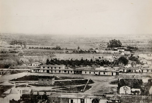
L.A. Plaza in the 1860s. Courtesy Braun Research Library Collection, Autry National Center
In an 1876 photo, the plaza is smaller and circle shaped, bordered neatly with trees, planted with grass, and the structures around it mostly have peaked American roofs, although a few adobe houses remain. A theater with the fancy false front and long windows of Victorian-era commercial buildings stands next to the Pico hotel. A vegetative fence camouflages the long low Olvera/Tapia adobe.
One of Ygnacio Coronel’s sons was Antonio Coronel whose recollections of Old California formed part of H. H. Bancroft’s history of California and whose stories delighted Helen Hunt Jackson. The Old Antonio Coronel Adobe stood on Arcadia Street (under the 101 freeway) and on adjacent side of the pueblo from Olvera’s adobe.
The mixture of Mexican names and American names for streets around and through the pueblo illustrates the transitions of the ways people in different times looked at the history of the Spanish, and then the Mexican, and then the American occupations of the same small area in downtown L.A.
The naming of Olvera Street is an example of one transition. The American City Council did nothing to preserve the Olvera Adobe. It had been an important building. Instead, the local American government preserved Olvera’s name.
Agustin Olvera was one of the signatories of the Treaty of Cahuenga, which ceded Los Angeles to the United States. He was the first judge in Los Angeles County. He held hearings and trials in his adobe from 1849-1853. He was also a member of the first Los Angeles City Council and later a County supervisor. Olvera was both a representative of L.A.’s past as a Mexican city and a symbol of the Mexican elite’s acceptance of American rule.
The renaming of Wine Street, on the other hand, reflects the American, largely Protestant, distaste for one of L.A.’s economic bases: the wine industry, which had its origins in the vast vineyards of the San Gabriel Mission.
Spain separated Alta and Baja California in 1804. Mexico won its independence from Spain in 1821. It took a year for the news to reach Los Angeles. In 1830, the population of Los Angeles reached 730. In 1835, the Mexican Congress decreed the pueblo of Los Angeles had become a city and made it the territorial capitol of Alta California.
The streets, therefore, originally had Spanish names. Alameda is Spanish.
Vine or Wine Street would have been Vid or Vino Calle.
By 1868, Los Angeles was California’s wine center, producing four million gallons of wine annually. The Mission San Gabriel put in 163,000 vines, all successful. Vines also grew at the San Fernando Mission.
Jose Maria Verdugo planted a vineyard north of Los Angeles on the Rancho San Raphael in 1799, in the San Raphael hills on the eastern side of the river. Antonio Lugo planted a vineyard in Los Angeles about 1810. Manuel Requena built a winery in Los Angeles about 1834, later becoming one of the city’s early mayors. Tiburcio Tapia – his daughter married vintner Victor Prodhomme – established a vineyard in the area around Cucamonga in 1838. Tapia inherited his father Bartolo Tapia’s adobe (Built in 1830) in the pueblo. He sold it to Olvera. Ricardo Vejar owned several vineyards on the Rancho San Jose in the Pomona area. Tomas Yorba had two vineyards in what is now Yorba Linda.
Joseph Chapman’s and then his son’s vineyard lasted from about 1826 to 1860. The Vignes Winery had its first vintage in 1837. Juan Domingo – born Johann Groningen in Holland — planted his vineyard (1828); Louis Bauchet’s vineyard lasted from 1828-1852. In 1838, William Wolfskill planted grapevines.
The pepper trees in pueblo courtyards Ina Coolbrith and her mother admired when Ina saw mature trees. If the Olvera Street pueblo was established either when La Placita was finished (1822) or earlier (The Avila Adobe, built in 1818), then they would have been mature trees when Ina was a student (from 1855).
By 1876, the L.A.’s built environment was largely American, although adobe houses remained in Sonora Town and in outlying areas through the 1950s.
Trains smoked their way through and into downtown Los Angeles, pausing at a depot in The Cornfield. A wooden covered bridge took Macy Street across the river.
In 1926, Christine Sterling spearheaded a movement to preserve the Francisco Avila Adobe, built in 1818 on what was by then Olvera Street. This became a successful campaign to build a Mexican marketplace on Olvera Street. Grapevines canopy the market stalls. These grow from vines planted in the courtyard of the Avila Adobe.
During the past 90 years Olvera Street has woven into local history but Olvera Street was not the birthplace of Los Angeles. Olvera Street was not, as it is advertised, “The First Street in Los Angeles.”
Olvera Street, the Plaza, the Avila Adobe, the Pico House (a hotel constructed between 1869 and 1870), the first fire station (1886), and the Chinese American Museum comprise El Pueblo de Los Angeles Historic Monument.
If you take the train to Los Angeles and emerge in the front of Union Station, your initial passage will be over what was once the notorious Calle de los Negroes where a mob of 500 men lynched about 20 Chinese men in 1871.
Cross the street at the signal. You will enter at this point the area that first Americans saw when they arrived in Los Angeles, although many of the early travelers arrived by stagecoach, which stopped in front of the Bella Union, now the Triforium, on the other side of the freeway. The Olvera Street area, although part of a historic park and although containing structures with historic interest, is not within any historian’s imagination a place that reflects early Los Angeles life.
Vendors now sell pottery, belts, wallets, purses, leather shoes, straw hats, T-shirts, posters, and Lucha Libre wrestling masks. If you look inside a hatband, you see the hat was made in one of the sweatshops south of downtown. Some of the labels say, “Made in China.” There is no folk art on Olvera Street. There was once a candle maker, two glass blowers, and a blacksmith. The tchotchkes used to be hand made but are now plastic.
You will pass on your right as you enter the plaza a bronze statue of Mexican actor and singer Antonio Aguilar riding a sombrero on a horse. The legend is that when he was a young actor looking for work, he slept on a bench in Olvera Street. There is no apparent connection of this statue with the founding of Los Angeles.
Leo Politi began his painting career sketching tourists in Olvera Street. You will pass his “The Blessing of the Animals” mural showing peasant children taking their goat, lamb, donkey, rabbit and dog to a monk to bless with holy water. Minstrels play a harp, a guitar and a violin on the back of the mural and white doves fly. The peasants in the mural look Italian. An Italian community did settle around the Olvera Street location. The historic Italian Hall is at the corner of Main and Macy Streets.
La Golondrina café started in 1924 as La Misión Café,located where City Hall (1928) stands. The owner moved the restaurant to Olvera Street’s Pelanconi House, a two story brick building built between 1855 and 1857. The building remains as the oldest firebrick building in Los Angeles. The restaurant was the first to serve real Mexican food instead of food called “Spanish.” The restaurant’s website incorrectly states Olvera Street was the 1781 birthplace of Los Angeles.
Seven other restaurants and taco stands provide Mexican food now, and at one of them, diners drink margaritas serenaded by Mariachi musicians.
The back of the Pico hotel is “headquarters” for the fictional California police force called the Bureau of Investigation in the television series The Mentalist (2008-2015). In one episode, “Patrick Jane,” a fake psychic, runs into Parking Lot No. 2 as he has figured out there is a bomb in a car parked in the lot. Parking Lot No. 2 is a corner of the approximate location of part of the Old Pueblo, the pueblo that existed either for about three-four years — or, if Estrada is correct in his estimate of the age of the present plaza for about 11-16 years.
Given the Spanish/Mexican flexibility in Los Angeles with respect to land titles, ownership and property boundaries yet another possible scenario is that the pueblo proper was located at a site closer to the toma than the Olvera Street pueblo proper is, that the number of settlers’ children and other emigrants swelled the population and that the settlers’ children and grandchildren and others built adobes along the Zanja Madre through what became Sonoratown, gradually digging the zanja as they built their new homes, extending it further, until the original 1781 adobes decayed. They then began a pueblo proper in the Parking Lot No. 2 location – which extended into Chinatown but it was at too high an elevation for the zanja to flow near it, so the houses gradually moved to a lower level, through which the zanja could be extended, a location almost smack on top of Yang-Na.
So the settlers with the help of the Indians swiveled the church to face what would be the new plaza and began building more adobes to face the new plaza: a gradual and slow process without anyone’s taking responsibility for an actual decision, much like the L.A. City Planning Department has worked since the City established a Planning Commission to prepare a comprehensive plan in 1915.
Planning decisions in Los Angeles have been since Neve’s first designation of home sites ad hoc and fragmented. The Planning Department website indicates L.A. land use planning has “a rich history.” No it does not. Private interests always determined urban changes in Los Angeles after the American occupation. A more accurate picture of planning in Los Angeles may be found in Robert Fogelson’s urban history classic The Fragmented Metropolis: Los Angeles 1850-1930. (University of California Press; Revised edition 1993)
A statue of Padre Junipero Serra holds a cross up for the tourists. Father Serra visited Los Angeles once, staying overnight and leaving the next day, about 40 years before the present plaza was built, at the location of the original pueblo.
The Spanish government gave the plaza a 2.5-ton statue of Juan Carlos III, King of Spain from 1759 to 1788. Juan Carlos extended Spanish control in the Americas and promulgated the Reglamento in 1772, which laid the foundation for colonizing California. In 1780, Juan Carlos agreed to the founding of a pueblo on the banks of the river at the location recommended by Friar Juan Crespi in 1769.
Xipe Topec (“New Life”) dance troupe performs Aztec dances in the plaza.
The pueblo of Los Angeles was for a time governed from Mexico City. None of the original settlers, however, came from Mexico City.
By the time Americans looked into the founding of Los Angeles, 1781 was a whisper of family recollections, and that whisper did not correspond to what the Americans assumed to be true and so went unheard.
The third part of “Where Did Los Angeles Start?” returns to 1769 and works up to the creation of the Olvera Street pueblo, which was in about 1818 to 1830.
Comments
Leave a Reply
You must be logged in to post a comment.
Honey on the road to San Francisco with some of the Spanish explorers
NOTES FROM ABOVE GROUND
By Honey van Blossom
(Honey is a Belgian Marxist former strip-tease artiste)

"Cities of the Golden Gate," Raymond Dabb Yelland, 1893. Most illustrations can be enlarged by clicking on them.
Prologue to the story of the Spanish exploration and settlement of California
Seasonal migrations of animals now extinct in California probably created the roads the native people used before the Spanish land exploration of California. “The heyday of giant mammals in North America was the middle and late Pleistocene, an epoch that started 2.6 million years ago and ended 11,700 years ago, around the time the Earth was thawing out from the Ice Age. The gigantic beasts, which migrated from Asia across a now-vanished land bridge called Beringia, are known as Rancholabrean megafauna, after the famous La Brea tar pits in downtown Los Angeles — the graveyard of thousands of saber-toothed tigers, giant bison and other extinct animals.”[1]
The seasonal migrations of the large mammals may have created the substantial roads used by the indigenous people after their arrival.[2]
Paul S. Martin and Richard G. Klein argue that Paleoindian over-hunting led to the extinction of the megafauna.[3] Others argue that climate change was responsible for mammoth and mastodon extinctions. As the last major glaciation ended around 12,000 years ago, climate warmed too quickly for the megafauna to adapt.

